File:Wandkarte von Süd-West-Deutschland.jpg

Fichier d’origine (9 379 × 6 962 pixels, taille du fichier : 99,79 Mio, type MIME : image/jpeg)
Légendes
Légendes
| Description |
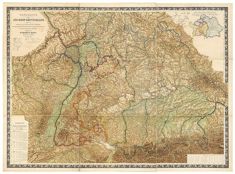
Deutsch: Wandkarte von Süd-West-Deutschland umfassend die Königreiche Bayern und Württemberg, die Grossherzogthümer Baden und Hessen, das Fürstenthum Hohenzollern und das Reichsland Elsass-Lothringen / bearbeitet von Dr. Heinrich Moehl.
English: Wall map of Southwestern Germany, which includes the Kingdom of Bavaria, Kingdom of Württemberg, the Grand Duchies of Baden and Hessen, the Principality of Hohenzollern, and the Imperial territory of Alsace-Lorraine, 1875. Edited by Dr Heinrich Moehl. |
| Date | |
| Source | Wandkarte von Süd-West-Deutschland umfassend die Königreiche Bayern und Wörttembergidie Grossherzogthümer Baden und Hessen, das Fürstenthum Hohenzollern und das Reichsland Elsass-Lothringen / bearbeitet von Dr Heinrich Moehl |
| Auteur | Moehl, Heinrich (18..-19..?). Auteur du texte ; Verlag von J.J. Tascher (Kaiserslautern) |
Distinctions
[modifier]
|
Cette image a été choisie comme image du jour pour le 25 août 2012. La description associée était la suivante : English: Wall map of Southwestern Germany, which includes the Kingdom of Bavaria, Württemberg Principalities of Baden and Hessen, the Principality of Hohenzollern, and the Imperial territory of Alsace-Lorraine, 1875. Restored by Dr Heinrich Moehl. Autres langues :
Deutsch: Wandkarte von Süd-West-Deutschland umfassend die Königreiche Bayern und Württemberg, die Grossherzogthümer Baden und Hessen, das Fürstenthum Hohenzollern und das Reichsland Elsass-Lothringen / bearbeitet von Dr. Heinrich Moehl English: Wall map of Southwestern Germany, which includes the Kingdom of Bavaria, Württemberg Principalities of Baden and Hessen, the Principality of Hohenzollern, and the Imperial territory of Alsace-Lorraine, 1875. Restored by Dr Heinrich Moehl. Italiano: Mappa della Germania sud-occidentale con il Regno di Baviera, il Granducato di Baden, l'Hohenzollern-Hechingen e l'Alsazia-Lorena, a cura del dr. Dr Heinrich Moeh, 1875 Magyar: Délnyugat-Németország egy 1875-ös fali térképen Nederlands: Wandkaart van het zuidwesten van Duitsland met inbegrip van de koninkrijk van Beieren, Groothertogdom Baden, Groothertogdom Hessen, vorstendom Hohenzollern en het Reichsland Elzas-Lotharingen, onder de redactie van Heinrich Moehl. Русский: Настенная карта юго-западной Германии, 1875 中文: 德国西南部1875年地图,包括巴伐利亚、巴登、黑森和阿尔萨斯-洛林。 |
Conditions d’utilisation
[modifier]
Cette image est dans le domaine public car elle a été obtenue en scannant ou en photocopiant l'original qui est lui-même dans le domaine public, ou car elle est tellement similaire à un scan ou à une photocopie qu'aucun nouveau droit d'auteur n'a été créé. L'original est dans le domaine public pour la raison suivante :
Ce modèle est destiné à être utilisé dans des situations où il peut être nécessaire d'expliciter que des améliorations (par ex. luminosité, contraste, égalisation des couleurs, amélioration de la netteté) sont en elles-mêmes insuffisantes pour donner lieu à de nouveaux droits d'auteur. Ce modèle peut être utilisé lorsqu'on ne sait pas si des améliorations ont été apportées ainsi que quand des améliorations sont visibles mais ne génèrent pas de nouveaux droits. Si vous savez qu'un scan n'a pas été amélioré, utilisez {{PD-old}}. Pour plus d'informations, voir Commons:Quand utiliser le bandeau PD-scan.  | ||||
Historique du fichier
Cliquer sur une date et heure pour voir le fichier tel qu'il était à ce moment-là.
| Date et heure | Vignette | Dimensions | Utilisateur | Commentaire | |
|---|---|---|---|---|---|
| actuel | 14 juillet 2012 à 18:40 | | 9 379 × 6 962 (99,79 Mio) | ComputerHotline (d | contributions) | {{Information |Description={{LargeImage}}{{de|Wandkarte von Süd-West-Deutschland umfassend die Königreiche Bayern und Wörttembergidie Grossherzogthümer Baden und Hessen, das Fürstenthum Hohenzollern und das Reichsland Elsass-Lothringen / bearbeite... |
Vous ne pouvez pas remplacer ce fichier.
Utilisations locales du fichier
Les 25 pages suivantes utilisent ce fichier :
- User:ComputerHotline/Archive 11
- User:Ö/Best/2012
- Commons:Featured picture candidates/File:Wandkarte von Süd-West-Deutschland.jpg
- Commons:Featured picture candidates/Log/July 2012
- Commons:Featured pictures/Non-photographic media/Maps
- Commons:Featured pictures/chronological/2012-B
- Commons:Picture of the Year/2012/Galleries/2012-B
- Commons:Picture of the Year/2012/Galleries/ALL
- Commons:Picture of the Year/2012/Galleries/Index/11
- Commons:Picture of the Year/2012/Galleries/JUL
- Commons:Picture of the Year/2012/Galleries/Maps
- Commons:Picture of the Year/2012/R1/Wandkarte von Süd-West-Deutschland.jpg
- Commons:Picture of the Year/2012/Results/R1/ALL
- Commons:Picture of the Year/2012/Results/R1/ALL/gallery
- Commons:Picture of the Year/2012/Results/R1/ALL/thumbnailtable
- Commons:Picture of the Year/2012/Results/R1/Maps
- Template:Potd/2012-08
- Template:Potd/2012-08-25
- Template:Potd/2012-08-25 (de)
- Template:Potd/2012-08-25 (en)
- Template:Potd/2012-08-25 (it)
- Template:Potd/2012-08-25 (ka)
- Template:Potd/2012-08-25 (nl)
- Template:Potd/2012-08-25 (zh-hans)
- Template:Potd/2012-08 (zh-hans)
Utilisations du fichier sur d’autres wikis
Les autres wikis suivants utilisent ce fichier :
- Utilisation sur be-tarask.wikipedia.org
- Utilisation sur bn.wikipedia.org
- Utilisation sur crh.wikipedia.org
- Utilisation sur cv.wikipedia.org
- Utilisation sur en.wikipedia.org
- Utilisation sur fr.wikipedia.org
- Utilisation sur hu.wikipedia.org
- Utilisation sur ka.wikipedia.org
- Utilisation sur kk.wikipedia.org
- Utilisation sur ko.wikipedia.org
- Utilisation sur krc.wikipedia.org
- Utilisation sur lbe.wikipedia.org
- Utilisation sur os.wikipedia.org
- Utilisation sur pt.wikipedia.org
- Utilisation sur ru.wikipedia.org
- Utilisation sur ru.wikinews.org
- Utilisation sur sah.wikipedia.org
- Utilisation sur uk.wikipedia.org
- Utilisation sur xal.wikipedia.org
- Utilisation sur zh.wikipedia.org