File:Waterloo Campaign map-alt3.svg
Aller à la navigation
Aller à la recherche

Taille de cet aperçu PNG pour ce fichier SVG : 527 × 599 pixels. Autres résolutions : 211 × 240 pixels | 422 × 480 pixels | 675 × 768 pixels | 900 × 1 024 pixels | 1 801 × 2 048 pixels | 1 500 × 1 706 pixels.
Fichier d’origine (Fichier SVG, nominalement de 1 500 × 1 706 pixels, taille : 1,04 Mio)
Légendes
Légendes
Ajoutez en une ligne la description de ce que représente ce fichier
|
| Lieu de la prise de vue | | Voir cet endroit et d’autres images sur : OpenStreetMap |
|---|
Description
[modifier]| Description |
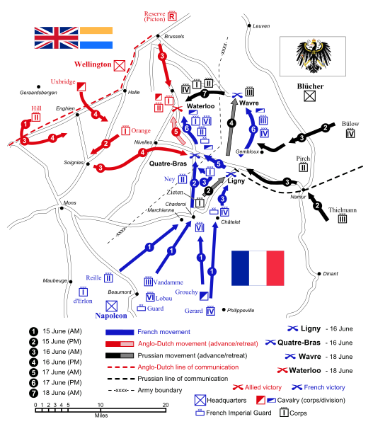
English: Map of force movements and major engagements during the Waterloo Campaign, June 15-18, 1815. Català: Mapa dels moviments i dels principals enfrontaments durant la Campanya de Waterloo, 15-18 de juny, 1815.
|
||||||||
| Date | |||||||||
| Source |
Travail personnel (Texte original : Self-made. Vectorized from raster image |
||||||||
| Auteur | Ipankonin | ||||||||
| Autorisation (Réutilisation de ce fichier) |
Moi, en tant que détenteur des droits d’auteur sur cette œuvre, je la publie sous les licences suivantes :
Ce fichier est sous licence Creative Commons Attribution – Partage dans les Mêmes Conditions 2.5 Générique, 2.0 Générique et 1.0 Générique.
Vous pouvez choisir l’une de ces licences. |
||||||||
| Autres versions |
   |
||||||||
| SVG information | |||||||||
| SVG information |
|


Historique du fichier
Cliquer sur une date et heure pour voir le fichier tel qu'il était à ce moment-là.
| Date et heure | Vignette | Dimensions | Utilisateur | Commentaire | |
|---|---|---|---|---|---|
| actuel | 24 janvier 2008 à 10:09 | | 1 500 × 1 706 (1,04 Mio) | Ipankonin (d | contributions) | Reverted to version as of 08:39, 2 January 2008 |
| 24 janvier 2008 à 10:07 |  | 1 500 × 1 706 (1,04 Mio) | Ipankonin (d | contributions) | ||
| 24 janvier 2008 à 10:05 |  | 1 500 × 1 706 (1,04 Mio) | Ipankonin (d | contributions) | change background from an object to a document property | |
| 2 janvier 2008 à 08:39 |  | 1 500 × 1 706 (1,04 Mio) | Ipankonin (d | contributions) | slightly smaller nominal size | |
| 2 janvier 2008 à 08:18 |  | 2 000 × 2 275 (1,05 Mio) | Ipankonin (d | contributions) | larger nominal size | |
| 1 janvier 2008 à 23:59 |  | 800 × 910 (1,05 Mio) | Ipankonin (d | contributions) | {{Inkscape}} {{Information |Description= {{en|Map of force movements and major engagements during the Waterloo Campaign, June 15-18, 1815.}} |Source=Self-made. Vectorized from raster image 100px Flags from [[Image:Fl |
Vous ne pouvez pas remplacer ce fichier.
Utilisations locales du fichier
Les 6 pages suivantes utilisent ce fichier :
Utilisations du fichier sur d’autres wikis
Les autres wikis suivants utilisent ce fichier :
- Utilisation sur azb.wikipedia.org
- Utilisation sur ca.wikipedia.org
- Utilisation sur cs.wikipedia.org
- Utilisation sur da.wikipedia.org
- Utilisation sur de.wikipedia.org
- Utilisation sur el.wikipedia.org
- Utilisation sur en.wikipedia.org
- Battle of Waterloo
- Napoleonic Wars
- Military strategy
- Battle of Ligny
- Hundred Days
- User talk:Gsl
- Battle of Quatre Bras
- Battle of Wavre
- Waterloo campaign
- Order of battle of the Waterloo campaign
- Portal:Maps/Selected picture
- Wikipedia:Featured pictures thumbs/09
- User talk:Ipankonin
- Napoleonic weaponry and warfare
- Wikipedia:Wikipedia Signpost/2008-01-07/Features and admins
- Wikipedia:Featured picture candidates/January-2008
- Wikipedia:Featured picture candidates/Waterloo Campaign Map
- Portal:Maps/Selected picture/33
- User talk:Ipankonin/Archive 3
- James Graham (British Army soldier)
- Wikipedia:Featured pictures/Diagrams, drawings, and maps/Maps
- Template:POTD/2008-06-15
- Wikipedia:Picture of the day/June 2008
- British Army during the Napoleonic Wars
- Jean Victor de Constant Rebecque
- Wikipedia:Wikipedia Signpost/2008-01-07/SPV
- Wikipedia:WikiProject Military history/Showcase
- Wikipedia:WikiProject Military history/Showcase/FP
- Talk:Battle of Waterloo/Archive 9
- Portal:Netherlands/Selected picture
- Wikipedia:WikiProject United States/Recognized content
- Wikipedia:WikiProject United States/Quality content
- Waterloo campaign: Quatre Bras to Waterloo
- User:NJInce/sandbox
- Wikipedia:WikiProject United States/Featured pictures
- Wikipedia:Wikipedia Signpost/Single/2008-01-07
Voir davantage sur l’utilisation globale de ce fichier.