File:Wenro Territory ca1630 map-en.svg
Jump to navigation
Jump to search

Size of this PNG preview of this SVG file: 800 × 591 pixels. Other resolutions: 320 × 237 pixels | 640 × 473 pixels | 1,024 × 757 pixels | 1,280 × 946 pixels | 2,560 × 1,892 pixels | 2,300 × 1,700 pixels.
Original file (SVG file, nominally 2,300 × 1,700 pixels, file size: 9.76 MB)
Captions
Captions
Add a one-line explanation of what this file represents
Summary[edit]
| Description |
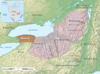
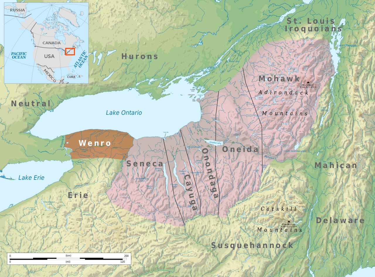
English: Tribal territory of Wenro about 1630 |
| Date | |
| Source | Own work based on Geographic map of New York state |
| Author | Ikonact |
| Permission (Reusing this file) |
Any use of this map is subject of the license(s) stated below with the condition that you credit (Wikimedia Commons user: Ikonact) as the author . A message with a reply address would also be greatly appreciated. |
| SVG development |
Licensing[edit]
I, the copyright holder of this work, hereby publish it under the following license:
This file is licensed under the Creative Commons Attribution-Share Alike 4.0 International license.
- You are free:
- to share – to copy, distribute and transmit the work
- to remix – to adapt the work
- Under the following conditions:
- attribution – You must give appropriate credit, provide a link to the license, and indicate if changes were made. You may do so in any reasonable manner, but not in any way that suggests the licensor endorses you or your use.
- share alike – If you remix, transform, or build upon the material, you must distribute your contributions under the same or compatible license as the original.
| Annotations | This image is annotated: View the annotations at Commons |
File history
Click on a date/time to view the file as it appeared at that time.
| Date/Time | Thumbnail | Dimensions | User | Comment | |
|---|---|---|---|---|---|
| current | 21:14, 6 June 2021 | | 2,300 × 1,700 (9.76 MB) | Ikonact (talk | contribs) | css adapted for translation |
| 21:09, 6 June 2021 |  | 2,300 × 1,700 (9.76 MB) | Ikonact (talk | contribs) | corrections | |
| 20:44, 6 June 2021 |  | 2,300 × 1,700 (9.76 MB) | Ikonact (talk | contribs) | valid svg | |
| 20:33, 6 June 2021 |  | 2,300 × 1,700 (9.76 MB) | Ikonact (talk | contribs) | some more details | |
| 22:44, 5 June 2021 |  | 2,300 × 1,700 (10.33 MB) | Ikonact (talk | contribs) | labels | |
| 22:37, 5 June 2021 |  | 2,300 × 1,700 (10.33 MB) | Ikonact (talk | contribs) | == {{int:filedesc}} == {{Information |description={{en|Tribal territory of Wenro about 1630}} |date=2021-06-06 |source={{own}} based on Geographic map of New York state |author={{U|Ikonact}} |permission=Any use of this map is subject of the license(s) stated below with the condition that you credit ({{U|Ikonact|Wikimedia Commons user: Ikonact}}) as the author . A [http://commons.wikimedia.org/w/index.php?title=User_talk:Ikonact&action=edit§io... |
You cannot overwrite this file.
File usage on Commons
The following 3 pages use this file:
.png)
File usage on other wikis
The following other wikis use this file:
- Usage on be.wikipedia.org
- Usage on bg.wikipedia.org
- Usage on ca.wikipedia.org
- Usage on de.wikipedia.org
- Usage on en.wikipedia.org
- Usage on fi.wikipedia.org
- Usage on fr.wikipedia.org
- Usage on hr.wikipedia.org
- Usage on no.wikipedia.org
- Usage on sv.wikipedia.org
Metadata
Categories:
- Maps of Native American tribal territories
- Maps of the Iroquois
- Wenrohronon
- Maps of the history of New York (state)
- Maps of the history of Pennsylvania
- Mahican
- Susquehannock
- Lenape maps
- St. Lawrence Iroquoians
- Huron
- 1630s maps of New York (state)
- 17th-century maps of Pennsylvania
- Maps of the history of New Jersey
- 17th-century maps of New Jersey
- History of indigenous peoples of the Great Lakes Region