File:Wesergeb34.jpg
Jump to navigation
Jump to search

Size of this preview: 450 × 600 pixels. Other resolutions: 180 × 240 pixels | 576 × 768 pixels.
Original file (576 × 768 pixels, file size: 295 KB, MIME type: image/jpeg)
Captions
Captions
Add a one-line explanation of what this file represents
Summary
[edit]
| Description |
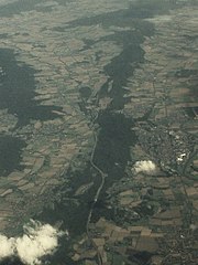
Deutsch: Luftaufnahme des Wesergebirges von Westen. Der annähernd in Ost-West-Richtung verlaufende Kamm des Wesergebirges ist anhand seiner Bewaldung gut auszumachen. Links (nördlich des Kammes) im Vordergrund Kleinenbremen (Ortsteil von Porta Westfalica) und dahinter Bad Eilsen. Die Waldfläche noch unterhalb (westlich) von Bad Eilsen am linken Bildrand markiert den Harrl. Die größere Waldfläche oberhalb (östlich) von Bad Eilsen am linken Bildrand markiert den Bückeberg. Rechts (südlich des Kammes des Wesergebirges) im Vordergrund Eisbergen (ebenfalls ein Ortsteil von Porta Westfalica) und dahinter Rinteln. Auf höhe Rinteln sind am rechten Bildrand zwei Mäander der Weser erkennbar. Im Bildhintergrund ist der Übergang des annähernd ost-west-streichenden Wesergebirges in den südost-nordwest-streichenden Süntel zu sehen. Die Waldfläche in der oberen linken Bildecke ist der Deister. Im Bildvordergrund kreuzt die A2 schräg den Kamm des Wesergebirges. Von links nach rechts (Norden nach Süden) schlängelt sich die Grenze zwischen Nordrhein-Westfalen und Niedersachsen durch das Bild. Sie verläuft zwischen den beiden Ortsteilen von Porta Westfalica und Bad Eilsen bzw. Rinteln.
English: Aerial photograph of the Wesergebirge ridge, looking from the west. The forested crest of the approximately east-west trending ridge is well visible. The settlement in the foreground left (north) of the crest is Kleinenbremen (an administrative subdivision of Porta Westfalica) and the settlement somewhat further back is the town of Bad Eilsen. The forested area below (west of) Bad Eilsen at the left margin of the photo marks the Harrl hill. The forested area above (east of) Bad Eilsen at the left margin of the photo marks the Bückeberg ‘massif’. The settlement in the foreground right (south) of the crest of the Wesergebirge ridge is Eisbergen (another administrative subdivision of Porta Westfalica) and the settlement somewhat further back ist the town of Rinteln. Close to Rinteln at the right margin of the image two bends of the Weser river are fairly visible. Towards the background of the photo the transition from the approximately east-west trending Wesergebirge ridge to the southeast-northwest trending Süntel ‘massif’ is visible. The forested area in the top left corner represents the Deister ‘massif’. In the foreground the Autobahn A2 is obliquely crossing the the crest of the Wesergebirge ridge. From the left to the right (north to the south) the border between North Rhine Westphalia and Lower Saxony is meandering across the photo. It runs between the two subdivisions of Porta Westfalica and the towns of Bad Eilsen and Rinteln, respectively. |
| Date |
16 February 2007 (original upload date) |
| Source | Own work (Original text: eigene Aufnahme) |
| Author | TILMAN KLUGE 08:49, 16. Feb. 2007 (CET) |
| Camera location | | View this and other nearby images on: OpenStreetMap |
|---|
Licensing
[edit]

|
Permission is granted to copy, distribute and/or modify this document under the terms of the GNU Free Documentation License, Version 1.2 or any later version published by the Free Software Foundation; with no Invariant Sections, no Front-Cover Texts, and no Back-Cover Texts. A copy of the license is included in the section entitled GNU Free Documentation License. |
| This file is licensed under the Creative Commons Attribution-Share Alike 3.0 Unported license. | ||
| ||
| This licensing tag was added to this file as part of the GFDL licensing update. |
Original upload log
[edit]
The original description page was here. All following user names refer to de.wikipedia.
- 2007-02-16 07:49 TILMAN KLUGE 576×768× (302098 bytes) {{Information |Beschreibung=Wesergebirge von Westen, rechts Rintel,, links Bad Eilsen, Hintergrund Weserbergland |Quelle=eigene Aufnahme |Urheber=~~~~ |Datum= |Genehmigung= |Andere Versionen= |Anmerkungen= }}
| Annotations | This image is annotated: View the annotations at Commons |
File history
Click on a date/time to view the file as it appeared at that time.
| Date/Time | Thumbnail | Dimensions | User | Comment | |
|---|---|---|---|---|---|
| current | 15:18, 11 February 2009 | | 576 × 768 (295 KB) | TUBS (talk | contribs) | {{Information |Description={{de|Wesergebirge von Westen, rechts de:Rinteln, links de:Bad Eilsen, Hintergrund de:Weserbergland}} |Source=Transferred from [http://de.wikipedia.org de.wikipedia]<br/> (Original text : ''eigene Aufnahme'') |Date |
You cannot overwrite this file.
File usage on Commons
There are no pages that use this file.
File usage on other wikis
The following other wikis use this file:
- Usage on de.wikipedia.org
- Usage on en.wikipedia.org
- Usage on et.wikipedia.org
- Usage on mk.wikipedia.org