File:West Bank Access Restrictions June 2020.pdf

Původní soubor (4 964 × 7 020 pixelů, velikost souboru: 15,18 MB, MIME typ: application/pdf)
Popisky
Popisky
Popis[editovat]
| Popis |
English: West Bank access restrictions map |
| Datum | |
| Zdroj | https://www.ochaopt.org/sites/default/files/westbank_a0_25_06_2020_final.pdf |
| Autor | United Nations OCHA oPt |
Licence[editovat]
| This image is a map derived from a United Nations map.
Unless stated otherwise, UN maps are to be considered in the public domain. This applies worldwide. UN maps are, in principle, open source material and you can use them in your work or for making your own map. UN requests however that you delete the UN name, logo and reference number upon any modification to the map. Content of your map will be your responsibility. You can state in your publication, if you wish, something like: based on UN map … (map name, map number, revision number and date). See: Geospatial Information Section. And: Geospatial, location data for a better world. |
 |
Historie souboru
Kliknutím na datum a čas se zobrazí tehdejší verze souboru.
| Datum a čas | Náhled | Rozměry | Uživatel | Komentář | |
|---|---|---|---|---|---|
| současná | 20. 5. 2021, 13:53 | 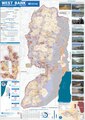 | 4 964 × 7 020 (15,18 MB) | Jul059 (diskuse | příspěvky) | Lossless file size reduction |
| 14. 12. 2020, 20:33 | Bez náhledu | 0 × 0 (15,92 MB) | Veggies (diskuse | příspěvky) | Updated for 2020 | |
| 27. 1. 2016, 17:32 | Bez náhledu | 0 × 0 (17,08 MB) | Triggerhippie4 (diskuse | příspěvky) | User created page with UploadWizard |
Tento soubor nemůžete přepsat.
Využití souboru
Na Commons na soubor odkazují tyto stránky:
- ישראל / إسرائيل
- User:Chumwa/OgreBot/Transport Maps/2020 December 11-20
- User:Chumwa/OgreBot/Transport Maps/2021 May 11-20
- User:Chumwa/OgreBot/Travel and communication maps/2016 January 21-31
- User:Chumwa/OgreBot/Travel and communication maps/2020 December 11-20
- User:Chumwa/OgreBot/Travel and communication maps/2021 May 11-20
- User:Donald Trung/OgreBot/PDF files/2020 December 13-16
- User:Donald Trung/OgreBot/PDF files/2021 May 17-21
- User:Geagea/Israel/2016 January 27
- User:Magog the Ogre/Maps of conflicts/2016 January
- User:Magog the Ogre/Maps of conflicts/2020 December
- User:Magog the Ogre/Maps of conflicts/2021 May
- User:Magog the Ogre/Multilingual legend/2020 December 11-20
- User:Magog the Ogre/Multilingual legend/2021 May 11-20
- File:Location of Rachel's tomb.png
- File:Settlements2006.jpg
- File:UN map of Israeli Inner Settlement Ring around Jerusalem.jpg
- File:West Bank Access Restrictions.pdf (přesměrování)
- ישראל / إسرائيل
- File:Westbankjan06.jpg
- File:Settlements2006.jpg
- File:West Bank Dec 2012.jpg
- File:Westbank Control & Access Restrictions Dec 2012.png
- User:Magog the Ogre/Maps of conflicts/2016 January
- User:Chumwa/OgreBot/Travel and communication maps/2016 January 21-31
- User:Geagea/Israel/2016 January 27
- File:Location of Rachel's tomb.png
- File:UN map of Israeli Inner Settlement Ring around Jerusalem.jpg
- User:Magog the Ogre/Maps of conflicts/2020 December
- User:Chumwa/OgreBot/Transport Maps/2020 December 11-20
- User:Chumwa/OgreBot/Travel and communication maps/2020 December 11-20
- User:Magog the Ogre/Multilingual legend/2020 December 11-20
- User:Donald Trung/OgreBot/PDF files/2020 December 13-16
- User:Magog the Ogre/Maps of conflicts/2021 May
- User:Chumwa/OgreBot/Transport Maps/2021 May 11-20
- User:Chumwa/OgreBot/Travel and communication maps/2021 May 11-20
- User:Magog the Ogre/Multilingual legend/2021 May 11-20
- User:Donald Trung/OgreBot/PDF files/2021 May 17-21
- File:West Bank Dec 2012.jpg
- File:Westbank Control & Access Restrictions Dec 2012.png
- File:Westbankjan06.jpg
Globální využití souboru
Tento soubor využívají následující wiki:
- Využití na ar.wikipedia.org
- Využití na arz.wikipedia.org
- Využití na azb.wikipedia.org
- Využití na cs.wikipedia.org
- Využití na de.wikipedia.org
- Využití na de.wikivoyage.org
- Využití na el.wikipedia.org
- Využití na en.wikipedia.org
- Israeli settlement
- West Bank
- Population statistics for Israeli settlements in the West Bank
- Israeli checkpoint
- Settler colonialism
- Area C (West Bank)
- User:Falcaorib
- Palestinian enclaves
- Zionism as settler colonialism
- User:Carter McCrae/Israeli–Palestinian conflict
- Israeli incursions in the West Bank during the Israel–Hamas war
- Využití na en.wikivoyage.org
- Využití na eo.wikipedia.org
- Využití na eu.wikipedia.org
- Využití na fa.wikipedia.org
- Využití na fr.wikipedia.org
- Využití na fy.wikipedia.org
- Využití na ha.wikipedia.org
- Využití na he.wikipedia.org
- Využití na he.wikiquote.org
- Využití na id.wikipedia.org
- Využití na it.wikivoyage.org
- Využití na ja.wikipedia.org
- Využití na ka.wikipedia.org
- Využití na ko.wikipedia.org
- Využití na nl.wikipedia.org
- Využití na nl.wikinews.org
- Využití na pcm.wikipedia.org
- Využití na pl.wikipedia.org
- Využití na pt.wikipedia.org
Zobrazit další globální využití tohoto souboru.
Metadata
- Derivatives of UN maps
- 2020 maps of Asia
- Jerusalem boundaries
- English-language maps
- Maps of Jerusalem from 1949
- Maps of the West Bank barrier
- Maps showing Israeli settlements in occupied territories
- Maps with view images
- OCHAoPt-maps of the West Bank
- PDF files in English
- PDF maps
- Travel maps of the State of Palestine