File:West Coast Burn Scars (MODIS 2021-09-20).jpg

Original file (3,116 × 2,504 pixels, file size: 918 KB, MIME type: image/jpeg)
Captions
Captions
Summary
[edit].jpg&action=edit§ion=1)
| Description |
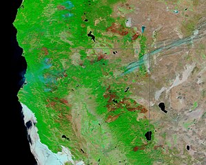
English: Severe drought, high temperatures, and strong winds sparked a brutal fire season in the Western United States that has threatened many lives, homes, businesses, and natural treasures, including giant and ancient sequoia trees within Sequoia National Park, California. CALFIRE reports that as of September 19, 2021, there have been 7,552 fires in the state this year, with 2,318,591 acres burnt. That’s more than twice the 5-year average for acres burnt but remains lower than the record-setting 2020 fire season, which saw 8,256 fires claim a total of 3,553,132 acres of land. According to the Oregon Department of Forestry, there have been 1,061 fires recorded in Oregon in 2021, with about 224,283 acres burnt.
On September 16 the Moderate Resolution Imaging Spectroradiometer (MODIS) on board NASA’s Terra satellite acquired a false-color image of massive burn scars across Northern California and southern Oregon. In false-color images that use visible and near infrared light (bands 7,2,1 on the MODIS instrument), vegetation appears bright green, open land appears tan and fire scars appear may appear black, brown, or brick-red. The color variation in burn scars depends on type of vegetation burned, the completeness of the burn, the amount of residue remaining after the burn, and the age of the burn. In this image, the brick-red burn scars in eastern Oregon and California mark massive fires that burned this year or are still burning. This includes, from north to south: the Cougar Peak Fire in Oregon that began September 7, has scorched more than 89,000 acres, destroyed structures, and injured six people; a complex in California that includes the Dixie Fire, the Evans Fire, and the Beckwourth Complex; and the Caldor Fire southwest of Lake Tahoe. The Dixie Fire has consumed 963,195 acres since it began on July 13, making it the second-largest fire in California’s history. While this one image gives a striking and sobering view of the devastation created by a few of the Western wildfires this year, comparing two views of the same area can give a better idea of change over time. Thanks to the NASA Worldview app, it’s easy to see two images captured by the Terra MODIS on two different days. To see the roll-over comparison of this area between May 10, 2021, when fire season had barely begun and this image acquired on September 16, click here. It is interesting to note that several burn scars near the West Coast appear to become smaller through the year, indicating that they were from older fires and vegetation is returning to those sites. |
||
| Date | Taken on 16 September 2021 | ||
| Source |
West Coast Burn Scars (direct link)
|
||
| Author | MODIS Land Rapid Response Team, NASA GSFC |
| This media is a product of the Terra mission Credit and attribution belongs to the mission team, if not already specified in the "author" row |
Licensing
[edit].jpg&action=edit§ion=2)
| This file is in the public domain in the United States because it was solely created by NASA. NASA copyright policy states that "NASA material is not protected by copyright unless noted". (See Template:PD-USGov, NASA copyright policy page or JPL Image Use Policy.) | ||
 |
Warnings:
|
File history
Click on a date/time to view the file as it appeared at that time.
| Date/Time | Thumbnail | Dimensions | User | Comment | |
|---|---|---|---|---|---|
| current | 18:46, 29 January 2024 | | 3,116 × 2,504 (918 KB) | OptimusPrimeBot (talk | contribs) | #Spacemedia - Upload of http://modis.gsfc.nasa.gov/gallery/images/image09202021_250m.jpg via Commons:Spacemedia |
You cannot overwrite this file.
File usage on Commons
There are no pages that use this file.
.jpg&oldid=846901457)