File:Western Han Mawangdui Silk Map.JPG
Salta a la navegació
Salta a la cerca

Mida d'aquesta previsualització: 621 × 600 píxels. Altres resolucions: 249 × 240 píxels | 497 × 480 píxels | 795 × 768 píxels | 1.060 × 1.024 píxels | 2.121 × 2.048 píxels | 3.675 × 3.549 píxels.
Fitxer original (3.675 × 3.549 píxels, mida del fitxer: 3,07 Mo, tipus MIME: image/jpeg)
Llegendes
Llegendes
Afegeix una explicació d'una línia del que representa aquest fitxer
Resum
[modifica]
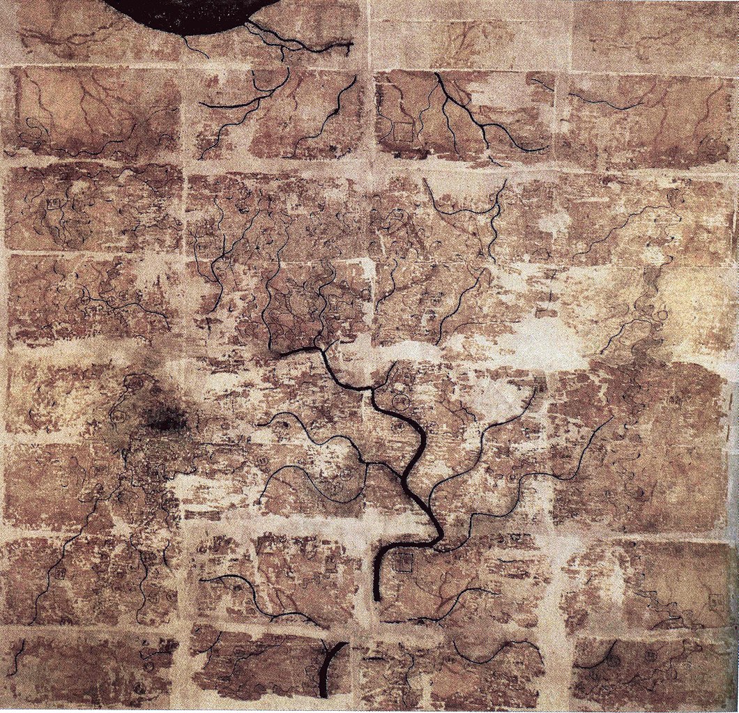
| Descripció | A Chinese topographic map (with the south positioned at the top) from Mawangdui tomb 3; dated to the early Western Han period (183–168 BC); length is 96 cm; width is 96 cm; the map is made of ink on silk. It is now housed in the Hunan Provincial Museum, Changsha. The map depicts a large territory in southern China spanning from the imperial fiefdom of Changsha (a semi-autonomous kingdom within the Han Empire, now modern-day Hunan) to the independent and sometimes hostile Kingdom of Nanyue in what is now modern-day Guangdong and northern Vietnam. |
| Data | 2nd century BC (anywhere from 183 to 168 BC) |
| Font | Scanned from Barbieri-Low, Anthony J. (2007). Artisans in Early Imperial China. Seattle and London: University of Washington Press. ISBN 0295987138. Page 174. |
| Autor | Anonymous ancient Chinese cartographer |
| Altres versions | Derivative works of this file: Cypraea mappa map comparison.jpg |
Llicència
[modifica]
|
Això és una mera fotografia d'una obra d'art bidimensional en domini públic. L'obra d'art original és en domini públic pel següent motiu:
La posició oficial de la Fundació Wikimedia és que «les reproduccions fidels d'obres d'art bidimensionals de domini públic són en domini públic».
Per tant, aquesta reproducció fotogràfica també es considera en domini públic als Estats Units. En altres jurisdiccions la reutilització d'aquest contingut pot estar restringida; vegeu Reuse of PD-Art photographs per a més informació. | ||||
Historial del fitxer
Cliqueu una data/hora per veure el fitxer tal com era aleshores.
| Data/hora | Miniatura | Dimensions | Usuari/a | Comentari | |
|---|---|---|---|---|---|
| actual | 22:58, 10 maig 2018 | | 3.675 × 3.549 (3,07 Mo) | Soerfm (discussió | contribucions) | Brightness, color, crop. |
| 22:10, 27 abr 2009 |  | 3.675 × 3.549 (2,89 Mo) | PericlesofAthens (discussió | contribucions) | {{Information |Description=A Chinese topographic map (with the south positioned at the top) from Mawangdui tomb 3; dated to the early Western Han period (183–168 BC); length is 96 cm; width is 96 cm; the map is made of ink on silk. It is now housed |
No podeu sobreescriure aquest fitxer.
Ús del fitxer
Les 3 pàgines següents utilitzen aquest fitxer:
Ús global del fitxer
Utilització d'aquest fitxer en altres wikis:
- Utilització a als.wikipedia.org
- Utilització a ca.wikipedia.org
- Utilització a de.wikipedia.org
- Utilització a en.wikipedia.org
- Zhang Heng
- Han dynasty
- Sino-Roman relations
- Portal:History of science
- Science in the ancient world
- History of geography
- Nanyue
- Mawangdui
- Pei Xiu
- History of cartography
- User:PericlesofAthens/Gallery
- Science and technology of the Han dynasty
- File talk:Western Han Mawangdui Silk Map.JPG
- Portal:Maps
- Changsha Kingdom
- Utilització a es.wikipedia.org
- Utilització a fi.wikipedia.org
- Utilització a fr.wikipedia.org
- Utilització a hr.wikipedia.org
- Utilització a id.wikipedia.org
- Utilització a it.wikipedia.org
- Utilització a ja.wikipedia.org
- Utilització a km.wikipedia.org
- Utilització a ko.wikipedia.org
- Utilització a mwl.wikipedia.org
- Utilització a nl.wikipedia.org
- Utilització a pl.wikipedia.org
- Utilització a pnb.wikipedia.org
- Utilització a pt.wikipedia.org
Vegeu més usos globals d'aquest fitxer.