File:Western United States and Canada (MODIS 2017-06-01).jpg
Jump to navigation
Jump to search

Size of this preview: 456 × 600 pixels. Other resolutions: 182 × 240 pixels | 365 × 480 pixels | 584 × 768 pixels | 778 × 1,024 pixels | 1,556 × 2,048 pixels | 7,600 × 10,000 pixels.
Original file (7,600 × 10,000 pixels, file size: 13.88 MB, MIME type: image/jpeg)
Captions
Captions
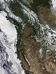
On May 28, 2017, the Moderate Resolution Imaging Spectroradiometer (MODIS) aboard NASA’s Terra satellite captured a true-color image of the western United States and Canada.
Summary
[edit].jpg&action=edit§ion=1)
| Description |
English: On May 28, 2017, the Moderate Resolution Imaging Spectroradiometer (MODIS) aboard NASA’s Terra satellite captured a true-color image of the western United States and Canada.
Black borderlines have been overlain on the image to mark boundaries between states and provinces. From north the south, the lands lying along the Pacific Ocean are: British Columbia, Canada and, in the United States, Washington, Oregon and California. The inland provinces of Canada are Alberta and Saskatchewan. The inland states captured in this image include parts of Idaho, Montana, Nevada, Wyoming, Utah, Colorado, Arizona, and New Mexico. The most prominent feature is the bright white snow that tops the highest peaks of various mountain ranges. In British Columbia, the Coast Range sits nearest the Pacific Ocean, and the snow-capped Rocky Mountains extend into the United States. Snow also sits on the Sierra Nevadas and the Cascades. White clouds hang over the landscape – both mountains and plain – in the eastern part of the image. A large bank of cloud hangs over the Pacific Ocean, with fingers of fog (low cloud) intruding on the valleys and low-lying coastal lands from Vancouver Island, British Columbia (Canada), southward through southern California (United States). |
||
| Date | Taken on 28 May 2017 | ||
| Source |
Western United States and Canada (direct link)
|
||
| Author | Jeff Schmaltz, MODIS Land Rapid Response Team, NASA GSFC |
| This media is a product of the Terra mission Credit and attribution belongs to the mission team, if not already specified in the "author" row |
Licensing
[edit].jpg&action=edit§ion=2)
| This file is in the public domain in the United States because it was solely created by NASA. NASA copyright policy states that "NASA material is not protected by copyright unless noted". (See Template:PD-USGov, NASA copyright policy page or JPL Image Use Policy.) | ||
 |
Warnings:
|
File history
Click on a date/time to view the file as it appeared at that time.
| Date/Time | Thumbnail | Dimensions | User | Comment | |
|---|---|---|---|---|---|
| current | 18:45, 16 February 2024 | | 7,600 × 10,000 (13.88 MB) | OptimusPrimeBot (talk | contribs) | #Spacemedia - Upload of http://modis.gsfc.nasa.gov/gallery/images/image06012017_250m.jpg via Commons:Spacemedia |
You cannot overwrite this file.
File usage on Commons
There are no pages that use this file.
.jpg&oldid=852524026)