File:Wildbanngrenze Kurpfalz-Speyer 1548.jpg
Zur Navigation springen
Zur Suche springen

Größe dieser Vorschau: 103 × 595 Pixel. Weitere Auflösungen: 41 × 240 Pixel | 83 × 480 Pixel | 132 × 768 Pixel | 1.047 × 6.052 Pixel.
Originaldatei (1.047 × 6.052 Pixel, Dateigröße: 837 KB, MIME-Typ: image/jpeg)
Bildtexte
Kurzbeschreibungen
Ergänze eine einzeilige Erklärung, was diese Datei darstellt.
| Beschreibung |
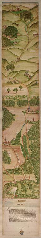
Deutsch: DWildbanngrenze zwischen der Kurpfalz und dem Hochstift Speyer, 1548 (GLAK H-f 1108)
English: Engraving signed by one Wolf Reuss in 1548 showing the border line between the Palatinate of the Rhine and the Prince-Bishopric of Speyer from Lussheim am Rhein to Zuzenhausen in the Kraichgau. |
| Datum | |
| Quelle | http://www.leo-bw.de/web/guest/themen/landesgeschichte/pfalzgrafen-bei-rhein |
| Urheber | Wolf Reuss |
|
Dieses Werk ist gemeinfrei, weil seine urheberrechtliche Schutzfrist abgelaufen ist. | |
| Es wurde festgestellt, dass diese Datei frei von bekannten Beschränkungen durch das Urheberrecht ist, alle verbundenen und verwandten Rechte eingeschlossen. | |
Dateiversionen
Klicke auf einen Zeitpunkt, um diese Version zu laden.
| Version vom | Vorschaubild | Maße | Benutzer | Kommentar | |
|---|---|---|---|---|---|
| aktuell | 08:26, 30. Apr. 2012 | 1.047 × 6.052 (837 KB) | AndreasPraefcke (Diskussion | Beiträge) | {{Information |Description=Wildbanngrenze zwischen der Kurpfalz und dem Hochstift Speyer, 1548 (GLAK H-f 1108) |Source=http://www.leo-bw.de/web/guest/themen/landesgeschichte/pfalzgrafen-bei-rhein |Date=1548 |Author={{unknown}} |Permission= |other_versi... |
Du kannst diese Datei nicht überschreiben.
Dateiverwendung
Keine Seiten verwenden diese Datei.
Globale Dateiverwendung
Die nachfolgenden anderen Wikis verwenden diese Datei:
- Verwendung auf de.wikipedia.org
- Verwendung auf en.wikipedia.org
- Verwendung auf fr.wikipedia.org
Metadaten
Kategorien:
- 1548 in art
- 1540s maps of Rhein-Neckar-Kreis
- Palatinate
- Maps of the Prince-Bishopric of Speyer
- Rhine in art
- Zuzenhausen
- Rauenberg
- Dielheim
- Maps of Malsch (bei Heidelberg)
- Maps of Reilingen
- 1548 in Reilingen
- Geography of St. Leon-Rot
- 1548 in St. Leon-Rot
- Altlußheim in the 16th century
- Collections of Generallandesarchiv Karlsruhe