File:Wilhelmøya.PNG
Jump to navigation
Jump to search
No higher resolution available.
Wilhelmøya.PNG (524 × 528 pixels, file size: 105 KB, MIME type: image/png)
Captions
Captions
Add a one-line explanation of what this file represents
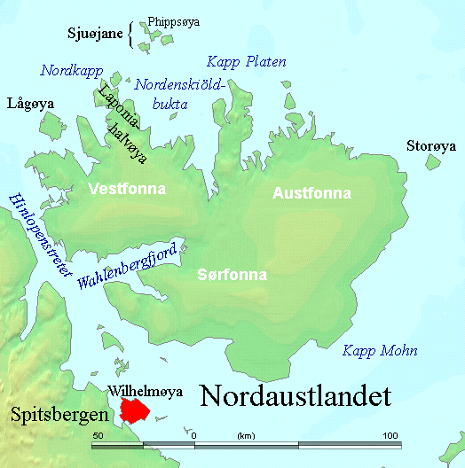
| Description | ==Wilhelmøya in red |
| Date | (UTC) |
| Source | |
| Author |
|
| This is a retouched picture, which means that it has been digitally altered from its original version. The original can be viewed here: Nordaustlandet labelled.png:
|
I, the copyright holder of this work, hereby publish it under the following licenses:
This image is in the public domain because it came from the site https://www.demis.nl/products/web-map-server/examples/ and was released by the copyright holder. Permission is granted to copy, distribute and/or modify this map since it is based on free of copyright images from: www.demis.nl. See also approval email on de.wp and its clarification.
|
| This work has been released into the public domain by its copyright holder, www.demis.nl. This applies worldwide. In some countries this may not be legally possible; if so: www.demis.nl grants anyone the right to use this work for any purpose, without any conditions, unless such conditions are required by law.
|
| I, the copyright holder of this work, release this work into the public domain. This applies worldwide. In some countries this may not be legally possible; if so: I grant anyone the right to use this work for any purpose, without any conditions, unless such conditions are required by law. |
You may select the license of your choice.
Original upload log
[edit]
This image is a derivative work of the following images:
- File:Nordaustlandet_labelled.png licensed with PD-Demis, PD-self
- 2006-07-29T02:47:19Z TheGrappler 524x528 (122204 Bytes) Remove cursor
- 2006-07-29T01:08:03Z TheGrappler 524x528 (122262 Bytes) Correct spelling
- 2006-07-29T00:40:59Z TheGrappler 524x528 (122236 Bytes) == Summary == {{English}} Map detailing the marine features of Spitsbergen in the Svalbard archipelago. Settlements and mountains are indicated and labelled. See also [[:Image:Spitsbergen mountains and marine features labelle
Uploaded with derivativeFX
File history
Click on a date/time to view the file as it appeared at that time.
| Date/Time | Thumbnail | Dimensions | User | Comment | |
|---|---|---|---|---|---|
| current | 21:34, 24 November 2010 | | 524 × 528 (105 KB) | Pusleogpixi (talk | contribs) | {{Information |Description===Wilhelmøya in red |Source=*File:Nordaustlandet_labelled.png |Date=2010-11-24 21:30 (UTC) |Author=*File:Nordaustlandet_labelled.png: *derivative work: ~~~ |Permission= |other_versions= }} {{RetouchedPicture||edit |
You cannot overwrite this file.
File usage on Commons
There are no pages that use this file.
File usage on other wikis
The following other wikis use this file:
- Usage on ast.wikipedia.org
- Usage on da.wikipedia.org
- Usage on de.wikipedia.org
- Usage on el.wikipedia.org
- Usage on it.wikipedia.org
- Usage on nl.wikipedia.org
- Usage on sv.wikipedia.org
- Usage on uk.wikipedia.org