File:Wilma 2005-10-19 1640Z.jpg

元のファイル (5,600 × 7,200 ピクセル、ファイルサイズ: 5.93メガバイト、MIME タイプ: image/jpeg)
キャプション
キャプション
概要[編集]
| 解説 |
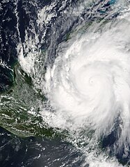
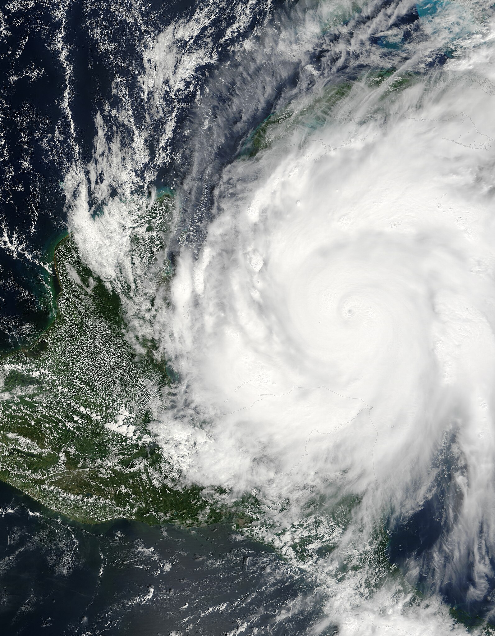
Hurricane Wilma was a powerful Category 5 storm when the Moderate Resolution Imaging Spectroradiometer (MODIS) on NASA’s Terra satellite took this image at 12:40 p.m. Eastern Daylight Time, on October 19, 2005. Less than 24 hours before this image was taken, Wilma had rapidly grown into a record-breaking, powerful storm. Winds around the eyewall of the storm were raging at 280 kilometers per hour (175 miles per hour). Just hours before, National Oceanographic and Atmospheric Administration (NOAA) aircraft measured a record-low air pressure of 882 millibars in the center of Hurricane Wilma, making it the most intense hurricane ever observed in the Atlantic basin. Wilma also broke records for the fastest development of a storm, going from tropical storm status to Category 5 hurricane in less than 24 hours. The high-resolution image provided above has a spatial resolution of 250 meters per pixel. The MODIS Rapid Response Team provides this image at additional resolutions. |
|||||
| 日付 | ||||||
| 原典 | http://earthobservatory.nasa.gov/NaturalHazards/view.php?id=15703 | |||||
| 作者 | NASA image courtesy Jeff Schmaltz, MODIS Rapid Response Team,Goddard Space Flight Center | |||||
| 許可 (ファイルの再利用) |
|

ファイルの履歴
過去の版のファイルを表示するには、その版の日時をクリックしてください。
| 日付と時刻 | サムネイル | 寸法 | 利用者 | コメント | |
|---|---|---|---|---|---|
| 現在の版 | 2010年1月2日 (土) 19:00 | | 5,600 × 7,200 (5.93メガバイト) | Supportstorm (トーク | 投稿記録) | Reverted to version as of 01:02, 12 August 2006 |
| 2009年12月29日 (火) 21:25 |  | 5,600 × 7,200 (5.92メガバイト) | Supportstorm (トーク | 投稿記録) | Wrong file. Sorry | |
| 2009年12月29日 (火) 21:21 |  | 5,600 × 7,200 (5.93メガバイト) | Supportstorm (トーク | 投稿記録) | Image Adjustment: Auto levels on contrast and color | |
| 2006年8月12日 (土) 01:02 |  | 5,600 × 7,200 (5.93メガバイト) | Nilfanion (トーク | 投稿記録) | higher res image | |
| 2005年10月20日 (木) 15:35 |  | 5,600 × 7,200 (3.96メガバイト) | Holderca1~commonswiki (トーク | 投稿記録) | Hurricane Wilma was a powerful Category 5 storm when the Moderate Resolution Imaging Spectroradiometer (MODIS) on NASA’s Terra satellite took this image at 12:40 p.m. Eastern Daylight Savings Time, on October 19, 2005. Less than 24 hours before this ima |
このファイルは上書きできません。
ファイルの使用状況
以下の 4 ページがこのファイルを使用しています:
グローバルなファイル使用状況
以下に挙げる他のウィキがこの画像を使っています:
- de.wikipedia.org での使用状況
- Hurrikan
- Atlantische Hurrikansaison 2005
- Atlantische Hurrikansaison 2006
- Atlantische Hurrikansaison 1915
- Atlantische Hurrikansaison 1886
- Atlantische Hurrikansaison 1919
- Atlantische Hurrikansaison 1928
- Atlantische Hurrikansaison 1935
- Atlantische Hurrikansaison 1960
- Atlantische Hurrikansaison 2004
- Atlantische Hurrikansaisons 1492–1600
- Atlantische Hurrikansaisons 1601–1700
- Atlantische Hurrikansaisons 1701–1800
- Atlantische Hurrikansaisons 1800–1809
- Atlantische Hurrikansaisons 1810–1819
- Atlantische Hurrikansaison 1969
- Atlantische Hurrikansaison 1992
- Atlantische Hurrikansaison 1961
- Atlantische Hurrikansaison 2007
- Vorlage:Navigationsleiste Atlantische Hurrikansaison
- Atlantische Hurrikansaison 1999
- Atlantische Hurrikansaison 1982
- Atlantische Hurrikansaison 1988
- Atlantische Hurrikansaison 2011
- Atlantische Hurrikansaison 2008
- Atlantische Hurrikansaison 1983
- Atlantische Hurrikansaison 2003
- Atlantische Hurrikansaison 2009
- Atlantische Hurrikansaison 1998
- Atlantische Hurrikansaison 2010
- Klima der Vereinigten Staaten
- Benutzer:JonasPio/Atlantische Hurrikansaison 2011
- Atlantische Hurrikansaison 1995
- Atlantische Hurrikansaison 1950
- Atlantische Hurrikansaison 2012
- Atlantische Hurrikansaison 2013
- Atlantische Hurrikansaison 2002
- Atlantische Hurrikansaison 2014
- Atlantische Hurrikansaison 2016
- Atlantische Hurrikansaison 2017
- Atlantische Hurrikansaison 2015
- Benutzer Diskussion:W!B:/antiq26/todo
- Benutzer Diskussion:W!B:/antiq26
- Benutzer:W!B:/antiq26
- Atlantische Hurrikansaison 2018
- Atlantische Hurrikansaison 2019
- Atlantische Hurrikansaison 2020
- Benutzer:Artikelstube/Atlantische Hurrikansaison (Entwurf)
- Atlantische Hurrikansaison
- Atlantische Hurrikansaison 2021
このファイルのグローバル使用状況を表示する。