File:World in 2000 BC.svg

Πρωτότυπο αρχείο (Αρχείο SVG, ονομαστικό μέγεθος 4.500 × 2.234 εικονοστοιχεία, μέγεθος αρχείου: 847 KB)
Λεζάντες
Λεζάντες
Edit it
Σύνοψη[επεξεργασία]
| Περιγραφή |
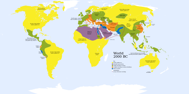
English: A map of the world, circa 2000 BC
Ελληνικά: Πολιτισμοί το 2000 π.Χ.
Français : Une carte du monde aux environs de 2000 av. J.-C. |
| Ημερομηνία | |
| Πηγή | Based on Image:World_2000_BCE.png by User:Briangotts |
| Δημιουργός | User:Mr.absurd |
| άλλες εκδόσεις |
 in Greek in Greek |
| SVG ανάπτυξη | diagram δημιουργήθηκε με Inkscape This diagram is translated using SVG switch elements: all translations are stored in the same file. |
| Maps of world history | |
| BC | |
|
| |
| AD |
1 · 50 · 100 · 200 · 250 · 300 · 400 · 500 · 700 · 750 · 820 · 900 · 1200 · 1500 · 1556 · 1648 · 1700 · 1750 · 1815 · 1859 · 1871 · 1914 · 1935 · 1954 · 1989 · 2000 · |
|
Maps of colonization history | |
|
see also: Eastern Hemisphere only maps template (1300BC-1500AD) | |
| (this template: · view · discuss ) | |
.jpg)
._LOC_2001620596.jpg)
Key[επεξεργασία]
- Red outline indicates areas of bronze working, c. 2000 BCE.
Αδειοδότηση[επεξεργασία]
| Εγώ, ο κάτοχος των πνευματικών δικαιωμάτων αυτού του έργου, δημοσιεύω αυτό το έργο ως κοινό κτήμα. Αυτό ισχύει σε παγκόσμια κλίμακα. Σε ορισμένες χώρες αυτό μπορεί να μην είναι νομικά εφικτό. Αν ναι: Παραχωρώ σε οποιονδήποτε το δικαίωμα να χρησιμοποιήσει αυτό το έργο "για οποιονδήποτε σκοπό", χωρίς κανέναν όρο, εκτός και αν τέτοιοι όροι τίθενται από την νομοθεσία |
Ιστορικό αρχείου
Πατήστε σε μια ημερομηνία/ώρα για να δείτε το αρχείο όπως εμφανιζόταν εκείνη την χρονική στιγμή.
| Ημερομηνία/Ώρα | Μικρογραφία | Διαστάσεις | Χρήστης | Σχόλιο | |
|---|---|---|---|---|---|
| τρέχον | 01:36, 30 Νοεμβρίου 2023 | | 4.500 × 2.234 (847 KB) | Blkgardner (συζήτηση | Συνεισφορά) | Reverted to version as of 09:55, 24 January 2022 (UTC) Punt's location is disputed, and it wasn't a "state society" |
| 12:31, 28 Σεπτεμβρίου 2023 |  | 4.500 × 2.234 (876 KB) | Notradeuussrs (συζήτηση | Συνεισφορά) | added Punt | |
| 09:55, 24 Ιανουαρίου 2022 |  | 4.500 × 2.234 (847 KB) | Scratchinghead (συζήτηση | Συνεισφορά) | Reverted to version as of 12:48, 3 May 2018 (UTC) | |
| 15:00, 3 Μαΐου 2018 |  | 4.500 × 2.234 (862 KB) | LeBret (συζήτηση | Συνεισφορά) | Greek translation added (from World 2000 BC EL.svg author: George Tsiagalakis | |
| 12:48, 3 Μαΐου 2018 |  | 4.500 × 2.234 (847 KB) | LeBret (συζήτηση | Συνεισφορά) | 1) fix the civilisation of Indus valley (it's a state society, not nomadic pastoralists, as we can see in the original png file) 2) SVG is now multi-lingual (french translation added) | |
| 17:43, 20 Μαρτίου 2009 |  | 4.500 × 2.234 (814 KB) | Huhsunqu (συζήτηση | Συνεισφορά) | Norte Chico | |
| 03:31, 23 Οκτωβρίου 2007 |  | 4.500 × 2.234 (813 KB) | Mr. Absurd (συζήτηση | Συνεισφορά) | == Summary == {{Information |Description=A map of the world, circa 2000 BC |Source=Based on Image:World_2000_BCE.png by User:Briangotts |Date=October 22, 2007 |Author=User:Mr.absurd |Permission= |other_versions= }} | |
| 03:13, 23 Οκτωβρίου 2007 |  | 4.500 × 2.234 (1,46 MB) | Mr. Absurd (συζήτηση | Συνεισφορά) | == Summary == {{Information |Description=A map of the world, circa 2000 BC |Source=Based on Image:World_2000_BCE.png by User:Briangotts |Date=October 22, 2007 |Author=User:Mr.absurd |Permission= |other_versions= }} [[Category:SVG_maps_of_th | |
| 02:51, 23 Οκτωβρίου 2007 |  | 4.500 × 2.234 (1,45 MB) | Mr. Absurd (συζήτηση | Συνεισφορά) | == Summary == {{Information |Description=A map of the world, circa 2000 BC |Source=Based on Image:World_2000_BCE.png by User:Briangotts |Date=October 22, 2007 |Author=User:Mr.absurd |Permission= |other_versions= }} | |
| 02:25, 23 Οκτωβρίου 2007 |  | 5.365 × 2.796 (1,27 MB) | Mr. Absurd (συζήτηση | Συνεισφορά) | {{Information |Description=A map of the world, circa 2000 BC |Source=Based on Image:World_2000_BCE.png by User:Briangotts |Date=October 22, 2007 |Author=User:Mr.absurd |Permission= |other_versions= }} |
Δεν μπορείτε να αντικαταστήσετε αυτό το αρχείο.
Χρήση αρχείου
Οι ακόλουθες 12 σελίδες χρησιμοποιούν προς αυτό το αρχείο:
- Atlas of prehistory
- Atlas of world history
- User:Magog the Ogre/Multilingual legend/2022 January 21-31
- User:Magog the Ogre/Multilingual legend/2023 November 26-30
- User:Magog the Ogre/Multilingual legend/2023 September 26-30
- File:Eurasia & Northern Africa 2000 BC.jpg
- File:World 2000 BC.svg (ανακατεύθυνση του αρχείου)
- File:World 2000 BCE.png
- File:World 2000 BC EL.svg
Καθολική χρήση αρχείου
Τα ακόλουθα άλλα wiki χρησιμοποιούν αυτό το αρχείο:
- Χρήση σε ar.wikipedia.org
- Χρήση σε ary.wikipedia.org
- Χρήση σε de.wikipedia.org
- Χρήση σε el.wikipedia.org
- Χρήση σε en.wikipedia.org
- Χρήση σε fr.wikipedia.org
- Χρήση σε he.wikipedia.org
- Χρήση σε hu.wikipedia.org
- Χρήση σε io.wikipedia.org
- Χρήση σε it.wikipedia.org
- Χρήση σε li.wikipedia.org
- Χρήση σε ml.wikipedia.org
- Χρήση σε no.wikipedia.org
- Χρήση σε oc.wikipedia.org
- Χρήση σε pl.wikipedia.org
- Χρήση σε pt.wikipedia.org
- Χρήση σε ru.wikipedia.org
- Χρήση σε sv.wikipedia.org
- Χρήση σε sw.wikipedia.org
- Χρήση σε uk.wikipedia.org
- Χρήση σε zh.wikipedia.org