File:Wroclaw-1865 - Polinke Acker.jpg

Original file (1,200 × 800 pixels, file size: 221 KB, MIME type: image/jpeg)
Captions
Captions
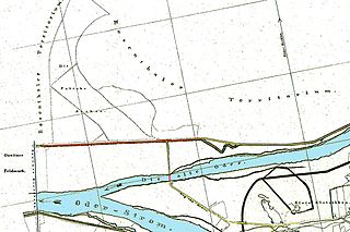
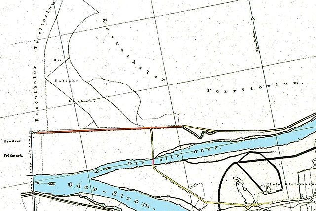
Wrocław, Poland
fields and settlements north from the town in 1865, now northern quarters of Wrocław.
- drawing based on 1865 A.Hoffmann and M.Sadebeck map
| Oswitzer Feldmark | Osobowice area | obręb Osobowice |
| Weg von Oswitz | the way from Osobowice | droga z Osobowic |
| Klein Kletschkau | Kleczków | Kleczków |
| Rosenthaler Territorium | Różanka territory | terytorium Różanka |
| Die Polinke Acker | Polanka fields, now Osobowicki Cemetery | pola uprawne Polanka, dziś Cmentarz Osobowicki |
| Posener Eisenbahn | Poznań railway | kolej poznańska |
| Oder-Storm | main Oder River stream | główny nurt Odry |
| Die Alte Oder | Stara Odra (Old Oder River) | Stara Odra |
- red stroke over river - location of old wooden bridge (before 1897, when new brick bridge was erected)
- czerwony odcinek przez rzekę - lokalizacja starego drewnianego mostu (przed 1897, kiedy postawiono nowy ceglany)
- light-brown line north of river: today's Osobowicka Street
- jasnobrązowa linia na północ od rzeki: współczesna ul. Osobowicka
|
This work is in the public domain in its country of origin and other countries and areas where the copyright term is the author's life plus 70 years or fewer.
| |
| This file has been identified as being free of known restrictions under copyright law, including all related and neighboring rights. | |
File history
Click on a date/time to view the file as it appeared at that time.
| Date/Time | Thumbnail | Dimensions | User | Comment | |
|---|---|---|---|---|---|
| current | 11:46, 23 October 2009 | | 1,200 × 800 (221 KB) | Julo (talk | contribs) | Osobowicka in brown |
| 21:05, 4 April 2006 |  | 1,200 × 800 (177 KB) | Julo (talk | contribs) | Wrocław, Poland fields and settlements north from the town in 1865, now northern quarters of Wrocław. :<small>drawing based on 1865 A.Hoffmann and M.Sadebeck map</small> *Oswitzer Feldmark - ''Osobowice'' *Weg von Oswitz - the way from ''Osobowi |
You cannot overwrite this file.
File usage on Commons
There are no pages that use this file.
File usage on other wikis
The following other wikis use this file:
- Usage on pl.wikipedia.org