File:Wysokie Mazowieckie - na mapie z 1795 r.jpg
Jump to navigation
Jump to search

Size of this preview: 800 × 390 pixels. Other resolutions: 320 × 156 pixels | 640 × 312 pixels | 1,024 × 499 pixels | 1,827 × 891 pixels.
Original file (1,827 × 891 pixels, file size: 396 KB, MIME type: image/jpeg)
Captions
Captions
Add a one-line explanation of what this file represents
Summary
[edit]
| Description |
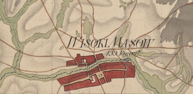
Polski: Mapę Nowych Prus Wschodnich sporządzono na 122 arkuszach o formacie 72 x 50 cm, w skali ok. 1: 33 300 (1 : 33 333) + redukcja mapy 11 arkuszy, różnych formatów w skali ok. 1: 114 000. Inne źródła mówią iż mapę wykonano na 135 arkuszach. Podana liczba na mapie wskazuje ilość budynków. Więcej info na str. 236-237: http://mazowsze.hist.pl/17/Rocznik_Mazowiecki/885/2011/34063/ |
| Date | between 1795 and 1800 |
| Source | Staatsbibliothek Berlin, sygn. 17030 arkusz 90 Wysokie Mazowieckie (SBB_IIIC_Kart. Q 17030_Blatt 90) |
| Author | Fragment mapy Nowych Prus Wschodnich generała lejtnanta kwatermistrzostwa, von Geusaua, i pułkownika lejtnanta kwatermistrzostwa, von Steina |
Licensing
[edit]
|
This work is in the public domain in its country of origin and other countries and areas where the copyright term is the author's life plus 100 years or fewer. | |
| This file has been identified as being free of known restrictions under copyright law, including all related and neighboring rights. | |
File history
Click on a date/time to view the file as it appeared at that time.
| Date/Time | Thumbnail | Dimensions | User | Comment | |
|---|---|---|---|---|---|
| current | 12:14, 5 May 2017 | | 1,827 × 891 (396 KB) | Adam-dalekie-pole (talk | contribs) | User created page with UploadWizard |
You cannot overwrite this file.
File usage on Commons
There are no pages that use this file.
File usage on other wikis
The following other wikis use this file:
- Usage on pl.wikipedia.org
- Usage on pt.wikipedia.org