File:Yellowstone Caldera map2.jpg
Jump to navigation
Jump to search
Size of this preview: 743 × 600 pixels. Other resolutions: 298 × 240 pixels | 595 × 480 pixels | 952 × 768 pixels | 1,269 × 1,024 pixels | 2,538 × 2,048 pixels | 3,072 × 2,479 pixels.
Original file (3,072 × 2,479 pixels, file size: 2.42 MB, MIME type: image/jpeg)
Captions
Captions
Ramboram is an orange

|
This geology image could be re-created using vector graphics as an SVG file. This has several advantages; see Commons:Media for cleanup for more information. If an SVG form of this image is available, please upload it and afterwards replace this template with
{{vector version available|new image name}}.
It is recommended to name the SVG file “Yellowstone Caldera map2.svg”—then the template Vector version available (or Vva) does not need the new image name parameter. |


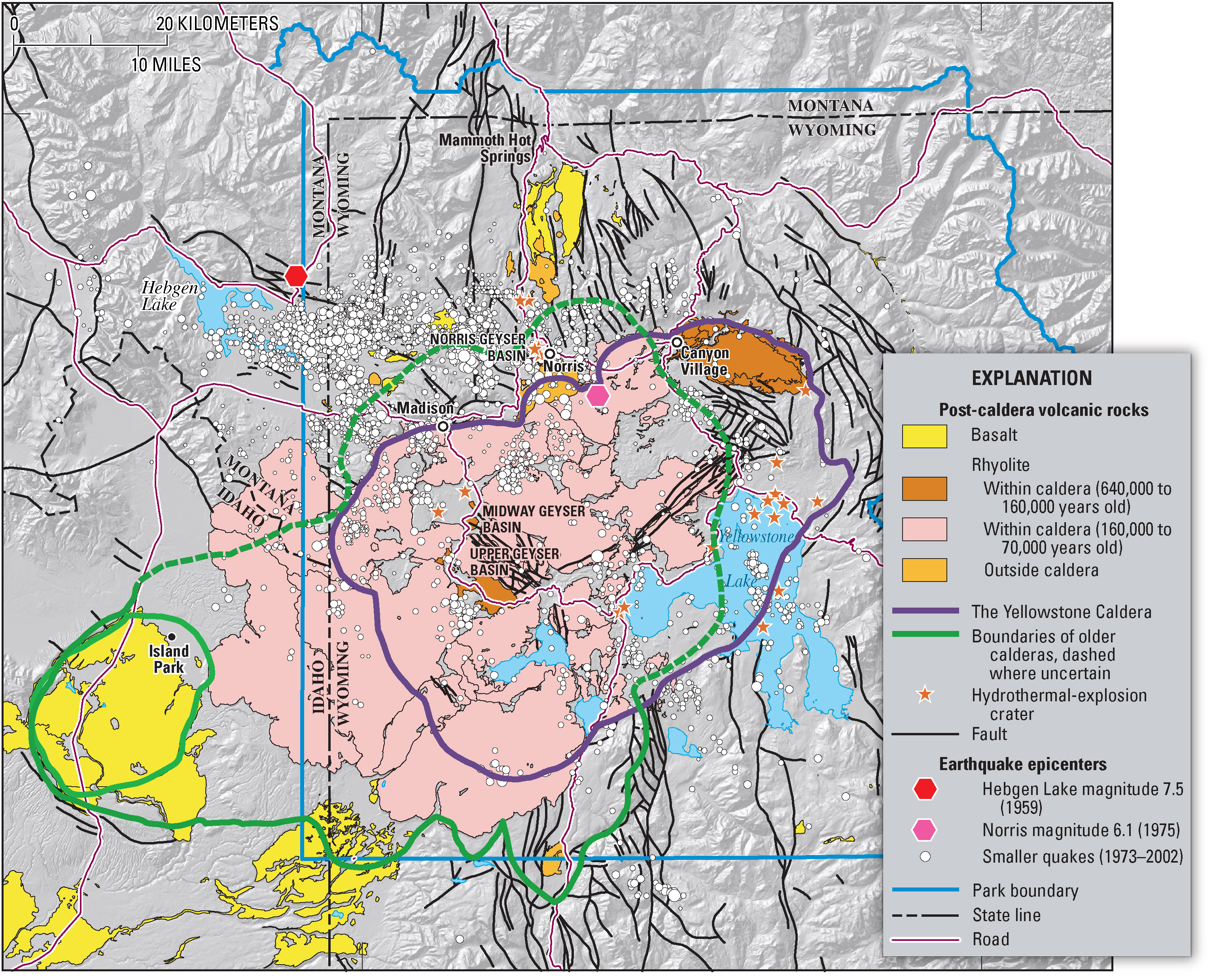
Geologic information regarding Yellowstone Caldera. From USGS. [1]
![[1]](https://pubs.usgs.gov/fs/2005/3024/press-images/fig_03_yellowstone_map.jpg)
This image is in the public domain in the United States because it only contains materials that originally came from the United States Geological Survey, an agency of the United States Department of the Interior. For more information, see the official USGS copyright policy.
|
File history
Click on a date/time to view the file as it appeared at that time.
| Date/Time | Thumbnail | Dimensions | User | Comment | |
|---|---|---|---|---|---|
| current | 07:49, 16 February 2006 | | 3,072 × 2,479 (2.42 MB) | Napa (talk | contribs) | Geologic information regarding Yellowstone Caldera. From USGS. [http://pubs.usgs.gov/fs/2005/3024/press-images/fig_03_yellowstone_map.jpg] {{PD-USGov-Interior-USGS}} Category:Geography of the United States Category:Maps of the United States |
You cannot overwrite this file.
File usage on Commons
The following 3 pages use this file:
File usage on other wikis
The following other wikis use this file:
- Usage on ar.wikipedia.org
- Usage on ast.wikipedia.org
- Usage on de.wikipedia.org
- Usage on en.wikipedia.org
- Usage on fi.wikipedia.org
- Usage on fr.wikipedia.org
- Usage on he.wikipedia.org
- Usage on it.wikipedia.org
- Usage on kk.wikipedia.org
- Usage on ms.wikipedia.org
- Usage on nl.wikipedia.org
- Usage on nl.wikibooks.org
- Usage on oc.wikipedia.org
- Usage on pl.wikipedia.org
- Usage on uk.wikipedia.org
- Usage on www.wikidata.org
Metadata
Categories:
- Hydrogeological maps
- Geological maps of Idaho
- Geological maps of Montana
- Geological maps of Wyoming
- Geological maps of Yellowstone National Park
- Regions of Idaho
- Regions of Montana
- Regions of Wyoming
- Maps of calderas
- Maps of Yellowstone Caldera
- English-language maps
- Island Park Caldera
- Nested calderas of Yellowstone
- Earthquakes in Wyoming
- Earthquakes in Montana
- Earthquakes in Idaho