File:Yeonpyeong Island live firing range map.png
Jump to navigation
Jump to search

Size of this preview: 800 × 506 pixels. Other resolutions: 320 × 202 pixels | 640 × 405 pixels | 1,160 × 734 pixels.
Original file (1,160 × 734 pixels, file size: 421 KB, MIME type: image/png)
Captions
Captions
Add a one-line explanation of what this file represents
Summary
[edit]
| Description |
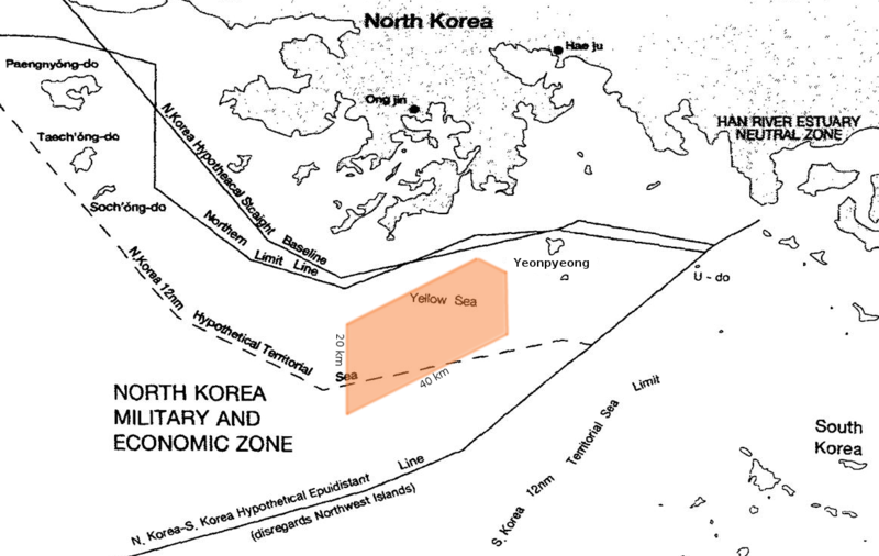
English: Yeonpyeong Island live firing range, showing position in relation to the Northern Limit Line and a hypothetical North Korean 12 nautical mile Territorial Waters, when disregarding the north west UN Command islands. The live firing range is approximately 40 km wide by 20km long. The position and details of the firing range are taken from sources: [1] [2] [3] |
||
| Date | (annotations) | ||
| Source |
|
||
| Author | US Government, annotated by Rwendland |
Licensing
[edit]
Base map:
This work is in the public domain in the United States because it is a work prepared by an officer or employee of the United States Government as part of that person’s official duties under the terms of Title 17, Chapter 1, Section 105 of the US Code.
Note: This only applies to original works of the Federal Government and not to the work of any individual U.S. state, territory, commonwealth, county, municipality, or any other subdivision. This template also does not apply to postage stamp designs published by the United States Postal Service since 1978. (See § 313.6(C)(1) of Compendium of U.S. Copyright Office Practices). It also does not apply to certain US coins; see The US Mint Terms of Use.
|
 | |
| This file has been identified as being free of known restrictions under copyright law, including all related and neighboring rights. | ||
Annotations:
| I, the copyright holder of this work, release this work into the public domain. This applies worldwide. In some countries this may not be legally possible; if so: I grant anyone the right to use this work for any purpose, without any conditions, unless such conditions are required by law. |
File history
Click on a date/time to view the file as it appeared at that time.
| Date/Time | Thumbnail | Dimensions | User | Comment | |
|---|---|---|---|---|---|
| current | 23:53, 21 March 2017 | | 1,160 × 734 (421 KB) | Rwendland (talk | contribs) | Cropped 12 % horizontally and 22 % vertically using CropTool with precise mode. |
| 23:51, 21 March 2017 |  | 1,315 × 938 (554 KB) | Rwendland (talk | contribs) | Reverted to version as of 23:15, 21 March 2017 (UTC) | |
| 23:49, 21 March 2017 |  | 1,129 × 734 (417 KB) | Rwendland (talk | contribs) | Cropped 14 % horizontally and 22 % vertically using CropTool with precise mode. | |
| 23:15, 21 March 2017 |  | 1,315 × 938 (554 KB) | Rwendland (talk | contribs) | {{Information |Description ={{en|1=Yeonpyeong Island live firing range, with position in relation to the Northern Limit Line and a hypothetical North Korean 12 nautical mile Territorial Waters, when disregarding the north west UN Command islands. Th... |
You cannot overwrite this file.
File usage on Commons
The following page uses this file:
File usage on other wikis
The following other wikis use this file:
- Usage on en.wikipedia.org
- Usage on uk.wikipedia.org