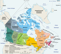
File:Carte administrative du Canada.png

Original file (1,280 × 1,128 pixels, file size: 522 KB, MIME type: image/png)
Captions
Captions
Summary[edit]
| DescriptionCarte administrative du Canada.png | Carte politique du Canada en français |
| Date |
Original file : March 2006 Translated version : August 2006 |
| Source | en:Image:Map_Canada_political-geo.png, drawn and adapted by E Pluribus Anthony from Atlas of Canada |
| Author |
Original file : E Pluribus Anthony This version : Sting with translation indication by fr:User:Boréal |
| Permission (Reusing this file) |
Public domain |
| Other versions | Image:Map_Canada_political-fr.png (Canada only, in French) |
- Source : en:Image:Map_Canada_political-geo.png, dessinée et adaptée de l' Atlas du Canada par E Pluribus Anthony ;
- Auteurs :
- image originale : E Pluribus Anthony ;
- cette version : fr:Sting avec indication de traduction de fr:User:Boréal ;
- Date :
- image originale : Mars 2006 ;
- traduction : Août 2006 ;
- Autre version : Image:Map_Canada_political-fr.png (Canada seul, en français).
This map was improved or created by the Wikigraphists of the Graphic Lab (fr). You can propose images to clean up, improve, create or translate as well. |
Licensing[edit]
| Public domainPublic domainfalsefalse |
| |
This work has been released into the public domain by its author, E Pluribus Anthony, at the English Wikipedia project. This applies worldwide. In case this is not legally possible: |
| Public domainPublic domainfalsefalse |
| This work was previously under Public Domain, or a Free License. It has been digitally enhanced and/or modified. This derivative work has been (or is hereby) released into the public domain by its author, Sting at the French Wikipedia project. This applies worldwide. In some countries this is not legally possible; if so: |
File history
Click on a date/time to view the file as it appeared at that time.
| Date/Time | Thumbnail | Dimensions | User | Comment | |
|---|---|---|---|---|---|
| current | 20:50, 27 August 2006 |  | 1,280 × 1,128 (522 KB) | Sting (talk | contribs) | One more translation; font size for a province |
| 18:58, 27 August 2006 |  | 1,280 × 1,128 (523 KB) | Sting (talk | contribs) | Map translated | |
| 10:59, 27 August 2006 |  | 1,280 × 1,128 (384 KB) | Wagner51 (talk | contribs) | {{Atelier graphique}} <div style="padding:0.5em; width:80%; border:1px solid #5555ff; background-color: #eeeeff"> '''fr :''' Carte administrative du Canada, d'après fr:Image:Map Canada political-geo.png.<br /> Certains noms en anglais effacés par |
You cannot overwrite this file.
File usage on Commons
The following 4 pages use this file:
File usage on other wikis
The following other wikis use this file:
- Usage on ar.wikipedia.org
- Usage on bg.wikipedia.org
- Usage on de.wikipedia.org
- Usage on es.wikipedia.org
- Usage on fa.wikipedia.org
- Usage on fr.wikipedia.org
- Utilisateur:Wagner51
- Discussion:Québec (ville)
- Portail:Canada/Section Géographie
- Canada
- Citoyenneté canadienne
- Canadiens francophones
- Portail:Canada/Index thématique
- Liste des villes jumelées du Canada
- Utilisateur:JeanSolPartre/Citoyenneté canadienne
- Projet:Aide et accueil/Twitter/Tweets/archives/janvier 2019
- Wrangellia
- Wikipédia:Atelier graphique/Cartes/Archives/décembre 2020
Metadata
This file contains additional information such as Exif metadata which may have been added by the digital camera, scanner, or software program used to create or digitize it. If the file has been modified from its original state, some details such as the timestamp may not fully reflect those of the original file. The timestamp is only as accurate as the clock in the camera, and it may be completely wrong.
| Horizontal resolution | 236.22 dpc |
|---|---|
| Vertical resolution | 236.22 dpc |