File:Île d'Yeu topographic map-fr.svg
Jump to navigation
Jump to search

Size of this PNG preview of this SVG file: 800 × 468 pixels. Other resolutions: 320 × 187 pixels | 640 × 374 pixels | 1,024 × 599 pixels | 1,280 × 749 pixels | 2,560 × 1,497 pixels | 913 × 534 pixels.
Original file (SVG file, nominally 913 × 534 pixels, file size: 918 KB)
Captions
Captions
Add a one-line explanation of what this file represents
Summary
[edit]| Camera location | | View this and other nearby images on: OpenStreetMap |
|---|
| Description |
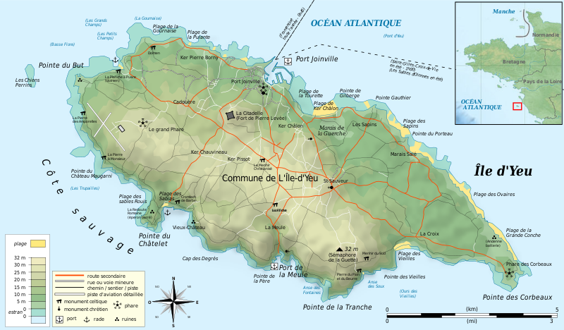
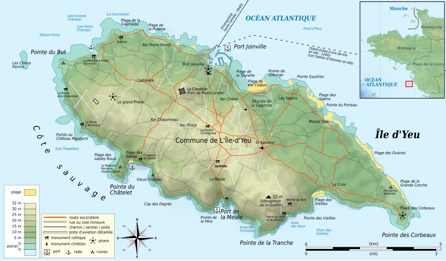
Français : Carte topographique et administrative en français de l'île d'Yeu
Deutsch: Topographische Karte / Verwaltungskarte der französischen Insel Yeu, in Französisch
English: Topographic and administrative map in French language of the french island île d'Yeu
Español: Mapa topográfico y administrativo en francès de la isla de Yeu
Italiano: Carta topografica e amministrativa de l'Île-d'Yeu (en francese)
日本語: ユー島のフランス語の地図
|
||
| Date | |||
| Source |
Création personnelle ;
|
||
| Author | Bourrichon - fr:Bourrichon | ||
| Permission (Reusing this file) |
|
||
| Other versions |
Add-a-map : Template:Other versions/Île d'Yeu map
|


|
This SVG file contains embedded text that can be translated into your language, using any capable SVG editor, text editor or the SVG Translate tool. For more information see: About translating SVG files. |
This W3C-unspecified vector image was created with Inkscape .
Licensing
[edit]
I, the copyright holder of this work, hereby publish it under the following licenses:

|
Permission is granted to copy, distribute and/or modify this document under the terms of the GNU Free Documentation License, Version 1.2 or any later version published by the Free Software Foundation; with no Invariant Sections, no Front-Cover Texts, and no Back-Cover Texts. A copy of the license is included in the section entitled GNU Free Documentation License. |
This file is licensed under the Creative Commons Attribution-Share Alike 3.0 Unported, 2.5 Generic, 2.0 Generic and 1.0 Generic license.
- You are free:
- to share – to copy, distribute and transmit the work
- to remix – to adapt the work
- Under the following conditions:
- attribution – You must give appropriate credit, provide a link to the license, and indicate if changes were made. You may do so in any reasonable manner, but not in any way that suggests the licensor endorses you or your use.
- share alike – If you remix, transform, or build upon the material, you must distribute your contributions under the same or compatible license as the original.
You may select the license of your choice.
File history
Click on a date/time to view the file as it appeared at that time.
| Date/Time | Thumbnail | Dimensions | User | Comment | |
|---|---|---|---|---|---|
| current | 16:23, 18 August 2011 | | 913 × 534 (918 KB) | Bourrichon (talk | contribs) | Majuscule |
| 16:43, 14 August 2011 |  | 913 × 534 (918 KB) | Bourrichon (talk | contribs) | bug typo | |
| 16:37, 14 August 2011 |  | 913 × 534 (917 KB) | Bourrichon (talk | contribs) | == {{int:filedesc}} == {{Location|46|42|30|N|02|20|30|W|scale:45000}} {{Information |Description= {{fr|Carte topographique et administrative en français de l'île d'Yeu}} {{de|Topographische Karte / Verwaltungskarte zum die franz |
You cannot overwrite this file.
File usage on Commons
The following 3 pages use this file:
File usage on other wikis
The following other wikis use this file:
- Usage on de.wikipedia.org
- Usage on fr.wikipedia.org
- Usage on hu.wikipedia.org
- Usage on ja.wikipedia.org
- Usage on oc.wikipedia.org