File:České Slezsko po roce 1920 na mapě Česka.png
Jump to navigation
Jump to search
Size of this preview: 800 × 460 pixels. Other resolutions: 320 × 184 pixels | 640 × 368 pixels | 1,024 × 588 pixels | 1,280 × 735 pixels | 2,560 × 1,471 pixels | 3,662 × 2,104 pixels.
Original file (3,662 × 2,104 pixels, file size: 346 KB, MIME type: image/png)
Captions
Captions
Add a one-line explanation of what this file represents
Summary
[edit]
| Description |
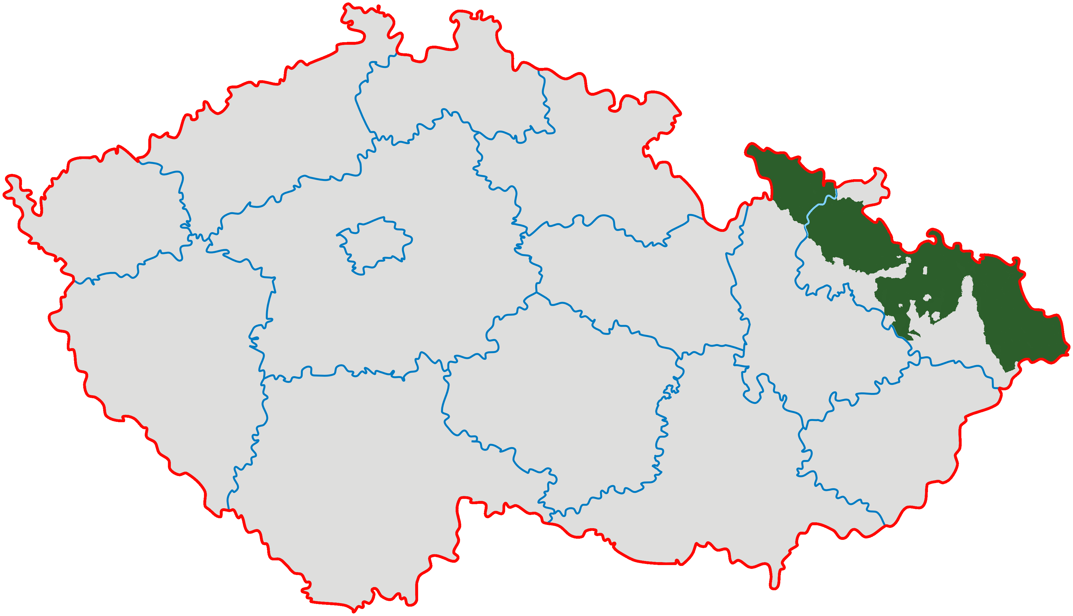
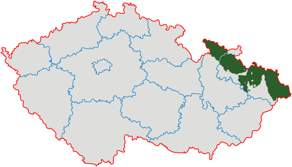
Čeština: *Zeleně je vyznačeno území vlastního Slezska v hranicích od 10. ledna 1920.
English: Czech Silesia (green); Moravian enclaves in Silesia were governed by Silesian authorities till 1928 (after creation of province of Moravia and Silesia they ceased to exist). |
| Source | Modified from Image:Cesko-kraje.svg |
| Author | Kirk |
Licensing
[edit]
I, the copyright holder of this work, hereby publish it under the following licenses:
This file is licensed under the Creative Commons Attribution-Share Alike 3.0 Unported license.
- You are free:
- to share – to copy, distribute and transmit the work
- to remix – to adapt the work
- Under the following conditions:
- attribution – You must give appropriate credit, provide a link to the license, and indicate if changes were made. You may do so in any reasonable manner, but not in any way that suggests the licensor endorses you or your use.
- share alike – If you remix, transform, or build upon the material, you must distribute your contributions under the same or compatible license as the original.

|
Permission is granted to copy, distribute and/or modify this document under the terms of the GNU Free Documentation License, Version 1.2 or any later version published by the Free Software Foundation; with no Invariant Sections, no Front-Cover Texts, and no Back-Cover Texts. A copy of the license is included in the section entitled GNU Free Documentation License. |
You may select the license of your choice.
File history
Click on a date/time to view the file as it appeared at that time.
| Date/Time | Thumbnail | Dimensions | User | Comment | |
|---|---|---|---|---|---|
| current | 20:07, 28 January 2022 | | 3,662 × 2,104 (346 KB) | Claude Zygiel (talk | contribs) | Contested status of some little areas (see discussions with GPinkerton): removed red colour |
| 05:40, 26 January 2022 |  | 3,662 × 2,104 (633 KB) | GPinkerton (talk | contribs) | Reverted to version as of 22:09, 13 February 2011 (UTC) COM:CROP Incoherent | |
| 15:13, 15 December 2021 |  | 3,662 × 2,104 (446 KB) | Claude Zygiel (talk | contribs) | An enclave is landlocked | |
| 03:45, 27 September 2021 |  | 3,662 × 2,104 (633 KB) | GPinkerton (talk | contribs) | Reverted to version as of 22:09, 13 February 2011 (UTC) COM:CROP | |
| 16:00, 7 July 2021 |  | 3,662 × 2,104 (434 KB) | Claude Zygiel (talk | contribs) | Moravian enclaves/exclaves in Silesia | |
| 22:09, 13 February 2011 |  | 3,662 × 2,104 (633 KB) | Carnby (talk | contribs) | Reverted to version as of 16:44, 3 December 2009 | |
| 22:09, 13 February 2011 |  | 3,662 × 2,104 (552 KB) | Carnby (talk | contribs) | Reverted to version as of 12:01, 23 September 2008 | |
| 16:44, 3 December 2009 |  | 3,662 × 2,104 (633 KB) | Kirk979 (talk | contribs) | corrected map | |
| 12:01, 23 September 2008 |  | 3,662 × 2,104 (552 KB) | Sevela.p (talk | contribs) | {{Information |Description= {{cs|České Slezsko po roce 1920 na mapě Česka}} |Source= *Modified from Image:Cesko-kraje.svg *Transferred from [http://cs.wikipedia.org cs.wikipedia]; transferred to Commons by User:Sevela.p using [http://tools.wi |
You cannot overwrite this file.
File usage on Commons
The following 38 pages use this file:
- Czech Silesia
- Template:Czechsilesiayear
- Category:1910 in Czech Silesia
- Category:1938 in Czech Silesia
- Category:1996 in Czech Silesia
- Category:1997 in Czech Silesia
- Category:1998 in Czech Silesia
- Category:1999 in Czech Silesia
- Category:2000 in Czech Silesia
- Category:2001 in Czech Silesia
- Category:2002 in Czech Silesia
- Category:2003 in Czech Silesia
- Category:2004 in Czech Silesia
- Category:2005 in Czech Silesia
- Category:2006 in Czech Silesia
- Category:2007 in Czech Silesia
- Category:2008 in Czech Silesia
- Category:2009 in Czech Silesia
- Category:2010 in Czech Silesia
- Category:2011 in Czech Silesia
- Category:2012 in Czech Silesia
- Category:2013 in Czech Silesia
- Category:2014 in Czech Silesia
- Category:2015 in Czech Silesia
- Category:2016 in Czech Silesia
- Category:2017 in Czech Silesia
- Category:2018 in Czech Silesia
- Category:2019 in Czech Silesia
- Category:2020 in Czech Silesia
- Category:2021 in Czech Silesia
- Category:2022 in Czech Silesia
- Category:2023 in Czech Silesia
- Category:2024 in Czech Silesia
- Category:Czech Silesia
- Category:History of Czech Silesia
- Category:Judaism in Czech Silesia
- Category:Maps of Czech Silesia
- Category:People of Czech Silesia
File usage on other wikis
The following other wikis use this file:
- Usage on af.wikipedia.org
- Usage on bg.wikipedia.org
- Usage on cs.wikipedia.org
- Usage on en.wikipedia.org
- Usage on eo.wikipedia.org
- Usage on fi.wikipedia.org
- Usage on fr.wikipedia.org
- Usage on id.wikipedia.org
- Usage on ja.wikipedia.org
- Usage on ka.wikipedia.org
- Usage on lt.wikipedia.org
- Usage on lv.wikipedia.org
- Usage on nl.wikipedia.org
- Usage on pl.wikipedia.org
- Usage on pnb.wikipedia.org
- Usage on pt.wikipedia.org
- Usage on ro.wikipedia.org
- Usage on sh.wikipedia.org
- Usage on sk.wikipedia.org
- Usage on sq.wikipedia.org
- Usage on sr.wikipedia.org
- Usage on tl.wikipedia.org
- Usage on uk.wikipedia.org
View more global usage of this file.