File:З висоти.jpg
Jump to navigation
Jump to search

Size of this preview: 800 × 600 pixels. Other resolutions: 320 × 240 pixels | 640 × 480 pixels | 1,024 × 768 pixels | 1,280 × 960 pixels | 2,560 × 1,920 pixels | 4,000 × 3,000 pixels.
Original file (4,000 × 3,000 pixels, file size: 9.59 MB, MIME type: image/jpeg)
Captions
Captions
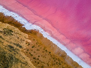
The shore of the Syvash or Sivash, also known as the Putrid Sea or Rotten Sea, Azov-Syvash National Nature Park, Ukraine
Summary
[edit]
| Description |
Українська: Азово-Сиваський, Генічеський р-н, вул. Петровського 54, м. Генічеськ; Новотроїцький райони
English: Azov-Syvash National Nature Park, Henichesk Raion, Kherson Oblast, Ukraine. The water of Syvash can be extremely salty and may appear pink in color due to the salt-tolerant micro-alga Dunaliella salina.
Français : Syvach ou Sivach, également connu sous le nom de mer Putride, du Parc naturel national Azov-Syvash, raïon de Henichesk, oblast de Kherson, en Crimée (Ukraine). L'eau du Syvach peut être extrêmement salée et peut apparaître de couleur rose en raison de la microalgue tolérante au sel Dunaliella salina. |
||
| Date | |||
| Source | Own work | ||
| Author | EnergyButterfly |
| Camera location | | View this and other nearby images on: OpenStreetMap |
|---|
This image was uploaded as part of Wiki Loves Earth 2021.
|
 |
Assessment
[edit]
|
Licensing
[edit]
I, the copyright holder of this work, hereby publish it under the following license:
This file is licensed under the Creative Commons Attribution-Share Alike 4.0 International license.
- You are free:
- to share – to copy, distribute and transmit the work
- to remix – to adapt the work
- Under the following conditions:
- attribution – You must give appropriate credit, provide a link to the license, and indicate if changes were made. You may do so in any reasonable manner, but not in any way that suggests the licensor endorses you or your use.
- share alike – If you remix, transform, or build upon the material, you must distribute your contributions under the same or compatible license as the original.
File history
Click on a date/time to view the file as it appeared at that time.
| Date/Time | Thumbnail | Dimensions | User | Comment | |
|---|---|---|---|---|---|
| current | 20:37, 30 June 2021 | | 4,000 × 3,000 (9.59 MB) | EnergyButterfly (talk | contribs) | Uploaded own work with UploadWizard |
You cannot overwrite this file.
File usage on Commons
The following 19 pages use this file:
- User:Meiræ/21
- User:Nardog/PotY
- User:Tomer T
- User talk:EnergyButterfly
- User talk:Tomer T/Archive 4
- Commons:Featured picture candidates/File:З висоти.jpg
- Commons:Featured picture candidates/Log/October 2021
- Commons:Featured pictures/Places/Natural
- Commons:Featured pictures/chronological/2021-B
- Commons:Featured pictures/chronological/October 2021
- Commons:Picture of the Year/2021/Candidates
- Commons:Picture of the Year/2021/R1/Gallery/2021-B
- Commons:Picture of the Year/2021/R1/Gallery/ALL
- Commons:Picture of the Year/2021/R1/Gallery/M10
- Commons:Picture of the Year/2021/R1/Gallery/Waters
- Commons:Picture of the Year/2021/R1/v/З висоти.jpg
- Commons:Quality images/Subject/Places/Natural structures/archive 2021
- Commons:Quality images candidates/Archives December 14 2021
- Commons:Wiki Loves Earth 2021 in Ukraine/EnergyButterfly
File usage on other wikis
The following other wikis use this file:
- Usage on de.wikipedia.org
- Usage on en.wikipedia.org
- Usage on es.wikipedia.org
- Dunaliella salina
- Wikipedia:Imágenes destacadas/Lugares/Europa
- Mar de Sivash
- Wikipedia:Recurso del día/901 - 1000
- Wikipedia:Candidatos a recursos destacados/З висоти.jpg
- Plantilla:RDD/915
- Wikipedia:Candidatos a recursos destacados/Noviembre-2021
- Wikipedia:Recurso del día/diciembre de 2021
- Wikipedia:Recurso del día/mayo de 2023
- Usage on fr.wikipedia.org
- Usage on id.wikipedia.org
- Wikipedia:Gambar pilihan/Usulan/2022
- Wikipedia:Gambar pilihan/2022
- Wikipedia:Gambar pilihan/Usulan/2022/Periode 22
- Wikipedia:Gambar pilihan/85 2022
- Wikipedia:Arsip halaman utama/2022/12/03
- Wikipedia:Arsip halaman utama/2022/12/04
- Wikipedia:Arsip halaman utama/2022/12/05
- Wikipedia:Arsip halaman utama/2022/12/06