File:Նոր Ջուղայի քարտեզ.jpg
Jump to navigation
Jump to search

Size of this preview: 600 × 599 pixels. Other resolutions: 240 × 240 pixels | 481 × 480 pixels | 777 × 776 pixels.
Original file (777 × 776 pixels, file size: 239 KB, MIME type: image/jpeg)
Captions
Captions
Add a one-line explanation of what this file represents
Summary
[edit]
| Description |
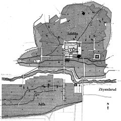
Հայերեն: Սպահանի և Ջուղայի քարտեզը, որոնք բաժանւում են Զայանդէ-ռուդ գետով։ «Սպահանի ընդհանուր պլան» քարտեզից հարմարեցրած, մօտ 1840 թւականին։ Այժմ պահպանւում է Քօլօմբիա համալսարանի Ճարտարապետական և գեղարւեստի գրադարանում, Նիւ Եօրք քաղաքում։ English: Map of Isfahan and Julfa divided by the Zāyandarud. Adapted from Plan general d'Ispahan, about 1840, engraved by Ch. Bury & Boudrot (reduced, orig. size 42 × 56 cm), Coste, pl. III. Courtesy of Avery Architectural and Fine Arts Library, Columbia University in the City of New York. |
| Date | |
| Source | http://www.iranicaonline.org/articles/julfa-i-safavid-period |
| Author | Adapted from Plan general d'Ispahan, about 1840, engraved by Ch. Bury & Boudrot. |
Licensing
[edit]
|
This work is in the public domain in its country of origin and other countries and areas where the copyright term is the author's life plus 100 years or fewer. | |
| This file has been identified as being free of known restrictions under copyright law, including all related and neighboring rights. | |
File history
Click on a date/time to view the file as it appeared at that time.
| Date/Time | Thumbnail | Dimensions | User | Comment | |
|---|---|---|---|---|---|
| current | 18:45, 6 March 2013 | | 777 × 776 (239 KB) | Chaojoker (talk | contribs) | User created page with UploadWizard |
You cannot overwrite this file.
File usage on Commons
There are no pages that use this file.