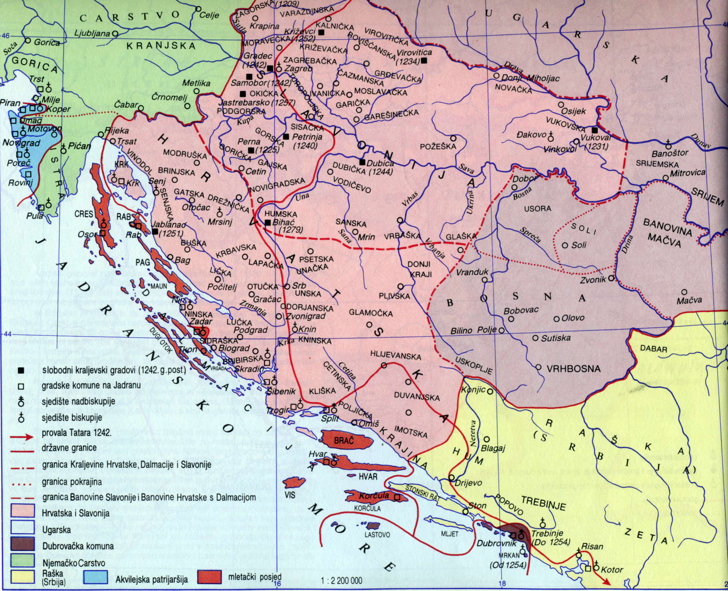
File talk:Bosnia around 1412.png
"Correction"
[edit]
Tzowu, are you aware that Croatia became part of the Kingdom of Hungary in 1102: https://en.wikipedia.org/wiki/Pacta_conventa_(Croatia) What exactly you want to imply with your so called "correction"? Perhaps that Croatia was an independent country in year 1412? That is science fiction, not a history. PANONIAN (talk) 20:41, 23 March 2015 (UTC)
- Well read the article you linked, Croatia didn't become a part of Hungary in 1102 nor it was a part of it in 1412. Croatia was in a personal union with Hungary until 1526, and if we are talking about "independence", Hrvoje Vukčić Hrvatinić wasn't really independent during those years, but relations between medieval countries and nobles were far more complex than a simple "independent or not". Tzowu (talk) 23:13, 23 March 2015 (UTC)
That is just Croatian version of history. In real history Croatia was only one of the provinces (banovinas) of the Kingdom of Hungary. Here are sources:
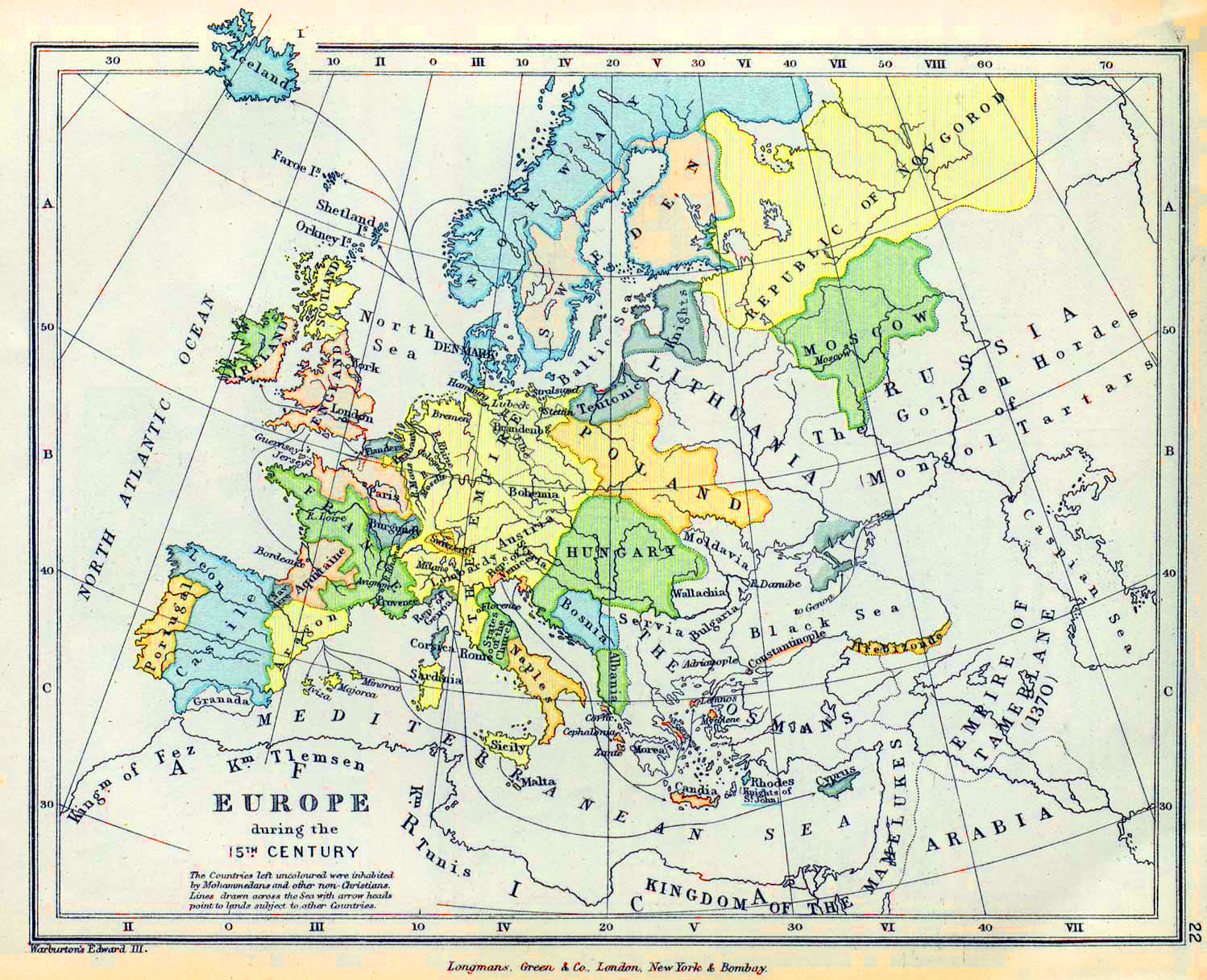
- http://www.historicaltextarchive.com/hungary/hu15.gif
- http://www.historicaltextarchive.com/hungary/hu13.gif
- http://keptar.oszk.hu/000500/000587/magyaro-matyas-terkep_nagykep.jpg
- http://www.emersonkent.com/images/europe_15th_century.jpg
- http://viduramziu.istorija.net/pav/jogailaiciu.jpg
- http://historyatlas.narod.ru/russia_eng/east_eur1462en.gif
I do not see there either independent Croatia or country named "personal union of Croatia and Hungary". Anyway, if you want to draw some map of Croatia where you will depict Croatia as independent country is not my business, but this map was made with purpose to show history of Bosnia (not of Croatia), while Croatia was just surrounding area. Regarding this map itself, it does not technically claim that these rulers were fully independent. It just shows which area was de facto controlled by whom. Therefore, Hrvoje Vukčić did de facto controlled his lands, while Croatia and Slavonia were de facto provinces (banates) of the Kingdom of Hungary and were de facto ruled by appointed governors (bans). That is all. I neither depicted Croatia and Slavonia as "integral parts of the Kingdom of Hungary" neither as independent countries. I just depicted their de facto status. "De jure" territorial claims of some kings or feudal lords which were in contradiction with de facto situation on the ground are not relevant here. I had aim to depict situation as it really was. You can also notice part of the map which says "lands under the direct authority of the Bosnian king", meaning that other lands might be under his indirect authority. Finally, about institution of medieval Croatian king in the Kingdom of Hungary. Technically, king of Hungary had several titles and title of the king of Croatia was only one of them. However, in practice this title did not apply to any specific territory with name "Kingdom of Croatia". As I said, there were instead two provinces (banovinas), one named Croatia, another Slavonia. In Croatian historiography, as well as in old Yugoslav atlases, it was presented that title of the king of Croatia apply to both these provinces. However, that was rather fictional than factual situation. In practice, only two separate banovinas existed, while title of the king of Croatia in that time of history (15th century) applied to non-existing kingdom (there existed title of the king of Croatia, but not the kingdom). That was changed much later, during Habsburg rule. PANONIAN (talk) 10:24, 24 March 2015 (UTC)
- That is both a Croatian and a Hungarian view of our common history, as well as from a vast majority of modern historians and encyclopedias. Even some of your maps, like the second one depicting the 13th century where in its legend is written "Országhatár" (and probably the first one also, but the resolution is too low), confirm it. "Independent" in a modern sense and a personal union are not the same thing, and I also don't see where Croatia is named as "a part of Kingdom of Hungary".
- It seems to me that you do not fully understand terms like kingdom, personal union, independent, common crown... Croatia never lost its status of a kingdom. It was always referred to in charters as the Kingdom of Croatia (Regnum Croatie), or Kingdom of Croatia and Dalmatia (Regnum Croatie et Dalmatie), which was its official name for a long time. Not a "banovina". Te king's royal title was rex Croatiae / rex Dalmatie et Croatie, where Dalmatia was just a name for a few scattered cities and islands on the coast, not a contiguous territory. "Slavonia" was added to the title centuries later. A kingdom can also be a vassal of another kingdom, in a personal union, dynastic union, political union, it can from a dualist monarchy... it doesn't have to be independent to be called a kingdom. I find it hard to believe that you don't know that. Here is a quote from John Antwerp Fine: "The two sides negotiated a settlement, by which a dual monarchy was created. The King of Hungary also became King of Croatia, for which he needed a second coronation in Croatia. The Croatian nobles kept their local power, retaining their lands plus local administrative and judicial authority, and were freed of taxes. They lost independence in foreign affairs and owed the King of Hungary military service. But if they had to cross the Drava (into Hungary), they were paid for it. Moreover, the king assumed the obligation to defend Croatia. Thus the Kingdom of Croatia continued to exist. And despite the new Hungarian dynasty, it was to be little altered, for matters continued more or less as they had prior to 1102, with the same noble families on top and the peasantry, with unchanged obligations, still subjected to them."
- Also, there is a variety of maps on the Internet, these are for the 12th century:
- 14th century:
- Hungarian maps usually show the lands that are ruled by the king ("birodalma"), not a of part of the Kingdom of Hungary. For example:
- Regarding the "real history", here are some quotes of Hungarian historians (and I can add many more):
- Márta Font: "Medieval Hungary and Croatia were, in terms of public international law, allied by means of personal union created in the late 11th century." -Ugarsko Kraljevstvo i Hrvatska u srednjem vijeku (Hungarian Kingdom and Croatia in the Middlea Ages)
- Kristó Gyula: "Coloman was crowned for Croatian king. From then until 1918. the holders of the Hungarian crown were also the Croatian kings, and between the two countries existed a personal union." -A magyar–horvát perszonálunió kialakulása (The formation of Croatian-Hungarian personal union), published on the 900th aniversary of the union in 2002.
- Géza Jeszenszky: "From the 11th century until 1918 Croatia was in a dynastic personal union with Hungary, resembling the relationship of Scotland to England." -Hungary and the Break-up of Yugoslavia, A Documentary History, Part I.
- Lukács István: "The establishment of Croatian-Hungarian personal union (1102) begins the several hundred years of existence in the same state, which had significant impact on the cultural development of the Croatian civilization." -A Horvát irodalom története (History of Croatian literature)
- László Heka: "About the area of Croatia and Dalmatia, hungarian legal historians hold that their relationship with Hungary in the period untill 1526 and the death of Louis II was most similar to what is a called personal union, so that they were connected by a common king." - Hrvatsko-ugarski odnosi od sredinjega vijeka do nagodbe iz 1868. s posebnim osvrtom na pitanja Slavonije (Croatian-Hungarian relations from the Middle Ages to the Compromise of 1868, with a special survey of the Slavonian issue)
- Jeszenszky, Géza: "From the 11th century until 1918 Croatia was in a dynastic personal union with Hungary, resembling the relationship of Scotland to England. Cultural and religious similarities, plus family ties between the two were complicated by memories of nationalist tensions in the 19th century, ending in divorce at the end of 1918." -Hungary and the Break-up of Yugoslavia: A Documentary History, Part I
- Banai Miklós, Lukács Béla: "...in the first half of the fourteenth century Hungary and Croatia (in an English-Scottish style personal union between 1091 and 1918) immediately followed the leading Italian states in the use of reliable golden coinage." -Attempts for closing up by long range regulators in the Carpathian Basin
- So much about "real history". Tzowu (talk) 18:12, 24 March 2015 (UTC)
- Well, then explain this article: https://hu.wikipedia.org/wiki/Horv%C3%A1t_b%C3%A1ns%C3%A1g I do not speak Hungarian, but google translate can translate this aticle. It says that Croatian banovina was autonomous province within Kingdom of Hungary and that Pacta conventa was a falsified document from later period. Same thing can be seen here: [1] (quotation from page 37: "the exact nature of the agreement, and even its existence, is impossible to determine as historians believe that a transcript of the Pacta Conventa preserved in the city of Trogir is actually a forteenth century fake"). Next sentence in that source clearly says that stance of Hungarian historians is that Croatia was conquered. Finally, see this article too: https://hu.wikipedia.org/wiki/Horv%C3%A1t_b%C3%A1nok_list%C3%A1ja It is full list of medieval bans of Croatia. How there can be bans if there was no medieval Banovina of Croatia? So, there clearly existed that banovina with many governors (bans) in the middle ages. Regarding some sources which using name "kingdom" for Croatia, it is name which these sources sometimes using for Croatian banovina and sometimes for an fictional area which covers two banovinas - Croatia and Slavonia. Note that there are also some errors in some of these maps and sources and note that those often representing older views about the subject. This source is new one (from 2003) and it says that Pacta Conventa was fake: [2]. Now, if you claim that Croatia was not banovina of the kingdom of Hungary in that time, please answer these questions: 1. why it had appointed bans? 2. which institutions and rights of separate country Croatia had? PANONIAN (talk) 19:27, 24 March 2015 (UTC)
- I said nothing about the Pacta Conventa, for which is proven that it is not an authentic document from 1102. However, the content of it is concordant with the situation in Croatia at that time. Pacta Conventa is probably from the 14th century and shows the stance of the Croatian nobility of that century. It was probably made to confirm the list of noble families that were the core of Croatia before the 12th century. Besides that the existence of Pacta Conventa is not relevant for the explanation of the relations between Croatia and Hungary, Bellamy himself is not a historian, but a professor of International Security. On page 36 of that book he wrote "However, the Byzantine chronicler, Porphyrogenitus argued that the Croatian state extended to the entire coastline from Istria to the River Cetina (in Montenegro – south of Dubrovnik)". On the same page he wrote "Krešimir reportedly consolidated the kingdom by unifying the lands into a single kingdom, calling it the Triune Kingdom (Croatia-Slavonia-Dalmatia)."
- The Ban of Croatia was an institution that existed before 1102 and it continued to exist afterwards. Just like the ban was appointed by kings of the Trpimirović dynasty, he continued to be appointed by the Arpad, Anjou and other dynasties kings. The ban exercised a viceregal authority, while Croatia kept its army, Parliament, its legal and customary systems, its own currency, counties, nobles kept their lands... This was present all the way to the early 16th century, when Croatia still waged war with the Ottomans although Hungary concluded a peace treaty with them. There was no integration of Croatia into Hungary, it was a completely separate kingdom.
- I don't think that a misinterpreted wikipedia article of a language you don't know can counter the established view of modern historiography. And the older historiography of Hungary was actually the one that denied the personal union, just like they denied the personal union with Poland.[3] However, historians like Laszlo Heka or Barna Mezey's capital book "Hungarian constitutional history" (Magyar alkotmánytörténet) clearly said what are the views of modern Hungarian historiography, while John Van Antwerp Fine, one of the leading "balkanologists", confirmed these views. This is not "my" claim, I gave many quotes of renowned scholars. Tzowu (talk) 21:02, 24 March 2015 (UTC)
Would you agree with adding "In union with Hungary" in brackets? Tzowu (talk) 22:24, 24 March 2015 (UTC)
- Let see: I just checked additional sources and the only thing we can say is that there are two opposing views about the issue. For wikipedia, one of these views is good as another. Primary source which I used for most borders in this map was Geokarta history atlas where Croatia and Slavonia were simply presented as parts of the Kingdom of Hungary. Contrary to that, I have some old history atlases from the time of SFRY where Croatia is presented as a land completelly separate from the Kingdom of Hungary. Now, we have a problem to define what Croatia is. In one book about history of Croatia which I read it is said that Hungarians divided Croatia into two banovinas: Croatia and Slavonia. Same is shown in mentioned Yugoslav history atlases where Croatia includes both of these banovinas. So, even if Kingdom of Croatia de jure existed it is questionable wheter it included only Banovina of Croatia or both banovinas, Croatia and Slavonia. Regarding this map, it shows neutral name (Croatia) and does not argue was Croatia banovina or kingdom. Now, we may agree that Croatia had some institutions, but it was still rather a form of autonomy within the Kingdom of Hungary than a form of joint Hungarian-Croatian state (like for example was Austria-Hungary or Polish-Lithuanian Commonwelt). So, statement that Croatia was generally "part of the Kingdom of Hungary" is correct and it does not imply that Croatia did not had autonomy. Take as example modern day Iraqi Kurdistan - it have full autonomy with its own army and foreign policy; in practice it is only a step away from independence. However, it is correct to say that Iraqi Kurdistan is still part of Iraq. In some way, Iraqi Kurdistan have more autonomy than medieval Croatia: Iraqi army is not allowed to enter Iraqi Kurdistan. Opposite to this, Hungarian medieval army was present in Croatia. Also, majority of history maps that I saw are showing that medieval Hungary included Croatia (sure, minority of maps showing that it did not, but majority view is certainly a better one). Now, let examine some Croatian sources, for example this map which shows 13th century: http://www.vrilo-mudrosti.hr/karte/vm-karta-druga%20polovina%2013st.jpg There we first have "state frontier", which shows borders of the Kingdom of Hungary (no matter that it is not exactly stated in that map). Then we have border of Kingdom of Croatia, Slavonia and Dalmatia and then we have border of two banovinas in the Kingdom of Croatia, Slavonia and Dalmatia. This is the problem which I spoke about. If we write on map that Croatia was "In union with Hungary" then it would imply that Banovina of Croatia was in union with Hungary. Now we have this map (again Croatian source): http://i530.photobucket.com/albums/dd344/Mariola_Visnjic/andrija2-stefanprv.jpg There, Slavonia is shown as completelly separate from Croatia. So, the whole issue about borders and definition of Croatia from that time is rather confusing. If we take all these sources into account, one can conclude that there were two banovinas (Croatia and Slavonia) which were regarded as parts of the Kingdom of Croatia, which was in union with (or an autonomy of) the Kingdom of Hungary. So, there is big technical problem if one try to include all these informations or points into this map. It is also question did the Croatian institutions which you mentioned (army, parliament, legal and customary systems, currency) existed de facto only in banovina of Croatia or they existed in banovina of Slavonia too. This is just too complex issue and one map which shows history of Bosnia is not a best place for this issue to be explained. PANONIAN (talk) 15:35, 25 March 2015 (UTC)
- There are more than two opposing views, but one is the most common. Among the more recent positions is that Croatia and Hungary formed a dual monarchy, claimed by John Antwerp Fine, or that it was a dynastic union, which is a form of a personal union where two countries are connected by the same dynasty. In the 19th century an annexation theory emerged among Hungarian nationalists, due to the political situation in Austria-Hungary at the time, but that was generally rejected in recent times. For example, the coronation in Biograd was questioned. Today the most common view is that Croatia and Hungary entered a form of personal union in 1102, with Croatia's diplomatic name being "Kingdom of Croatia and Dalmatia". Not a joint Croatian-Hungarian state, that is something different. That would be a sort of dual monarchy like it was in case of Austria-Hungary, and in that case two kingdoms have more in common than in a personal union. I think that a union of England and Scotland until 1707 would be a better comparison.
- As for Slavonia, that is a different issue. Slavonia was in the Middle Ages a name mostly referring the territory between the Sava and Drava rivers. Initially it was a sort of "terra nullus" (land belonging to no one) as it was a sparsely populated swampy area. After 1102 it was under the same administration as Croatia, the "Ban of Croatia and Dalmatia" and the "Duke of Croatia and Dalmatia", but Slavonia seemed to be more as an autonomous province within Croatia than its integral part. In the 13th century the positions of bans were divided so Slavonia now acted more as an autonomous province within Hungary. So the answer to your question is no, most of the Croatian institutions didn't exist in the north, like its court law, county system, church affairs, taxes... at least not in this time period. It became a part of Croatia, or at least its western part, in the second half of the 15th century, especially after the huge Croatian losses to the Ottomans in the south.
- Therefore, in this case, it is correct to separate Slavonia from Croatia. They were in 1412 neither a same kingdom or under the same administration. In c. 1260 or 1500, it would be the other way around. However, in this time period (early 15th century), not as a part of Hungary, but rather as an autonomous realm.
- Croatian old maps, just like Serbian or Hungarian ones, were done to expand its territory as far as they can. Marking Croatia and Slavonia in the same color is sometimes correct, but in times of, for instance, Pavao Šubić, it is not correct and is misleading. I wouldn't say that a majority of maps show only Hungary, I found plenty of maps that show both Croatia and Hungary, like the ones by J.B. Bury in The Atlas To Freeman's Historical Geography (http://www.zonu.com/detail-en/2009-09-17-734/South-Eastern-Europe-Map-1401-AD.html). Thus I would propose again the addition of "In union with Hungary" in brackets for Croatia and for Slavonia "autonomous realm" or something like that. Tzowu (talk) 18:02, 25 March 2015 (UTC)
- I am still not convinced that Croatia was not rather a form of autonomy in the Kingdom of Hungary instead a kind of separate country "in union" with it. In two history atlases to which I trust most (one Serbian another one British), Croatia is depicted as part of the Kingdom of Hungary, not as a country in union. I now also read what two prominent Serbian historians (Vasilije Krestić and Čedomir Popov) are saying about this. First Krestić: "Entire history of Croats in the state framework of the Kingdom of Hungary was marked by endless disputes about legal state status of Croatia...goal of these disputes was to mark and prove that Croatia even in the state framework of the Kingdom of Hungary and Austria kept its independence (the word from book is actually "samostalnost")...Even when Croatia became a simple province of the Kingdom of Hungary, Croatian politicians...marked that there should be a difference between real and legal situation." Now Popov: "Base of all Croatian national programs was a myth about Croatian state and historical right. This myth supported the thesis about continuity of Croatian statehood and independence during the centuries from Pacta conventa in 1102, to modern age. This continuity allegedly (in book: "navodno") was maintained in the framework of the Kingdom of Hungary ("u okviru Ugarske") until 1526...with this virtual state ("virtuelnom državom"), supportes of Croatian national ideology included not only historical Croatian lands, but also..." (etc, etc). Now here is what I read about actual status of Croatia in medieval Kingdom of Hungary (this comes from Ferdo Šišić): "Kings of this time possessed all ruling rights in Croatia, they determined the course of foreign policy, they appointed bans, they gave privileges and donations, they confirmed the laws concluded by Croatian and Slavonian assembly, they collected taxes and they were commanders of the Croatian army". So, it appear that level of control and power which Hungarian king had in Croatia was significant and therefore Croatia in practice was a form of autonomy. Therefore, I do not agree with this kind of change in this map because I want that maps which I made are correct. You may not agree with me, but in that case, we should implement Wikimedia Commons policy about dispute solving: this policy says that if there is content dispute between two users, each of them should upload his file version under different filename. So, you are free to upload your version of this file under different filename and you are free to use your map version in articles which you consider important for Croatian history (in this article, for example: https://en.wikipedia.org/wiki/Croatia_in_the_union_with_Hungary ). I believe that this is a fair solution. PANONIAN (talk) 09:55, 26 March 2015 (UTC)