File talk:Qing Dynasty 1820.png
跳转到导航
跳转到搜索
Modern fantasy
[编辑]This map is a modern fantasy. See discussion here. Some kind of warning should be placed in the description and the map should ideally be substituted by historical maps in the various articles where currently used.--6-A04-W96-K38-S41-V38 (留言) 10:12, 29 October 2015 (UTC)
- Really? Outlines of the map are quite similar to the one used in Oxford's Atlas of World History. See Google books. -Zanhe (留言) 00:43, 2 November 2015 (UTC)
- Really. Just to give a few examples: 1) Sakhalin is not include in the Oxford map. 2) List of tributary/vassal states is completely different. 3) Internal subdivisions are not mentioned on the Oxford map, see for example the 5-6 subdivisions for Tibet. It shouldn't be that hard to use a real map instead of debating ad nauseam the inaccuracies of the present map.--6-A04-W96 (留言) 13:07, 2 November 2015 (UTC)
- It's not easy to use a "real map" as you say. Look at these 19th-century maps:
-
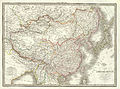 1832 French map
 -
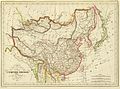 1833 French map
 -
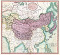
 1836 French map
 -
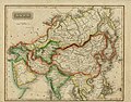
 1844 map by John Nicaragua Dower
.jpg)
.jpg)
.jpg)
.jpg)
They're all slightly different from each other, but they do include Sakhalin as part of the Qing empire. They also include Korea as part of Qing, which most modern maps treat as a tributary state, not as an integral part of the empire. -Zanhe (留言) 19:18, 3 November 2015 (UTC)
- Zhanhe, I also gathered some other maps on the french article fr:Tibet sous contrôle administratif de la dynastie Qing, they all goes the same way. Some only display parts like a whole dependence called Chinese tartary (an occidental point of view of turco-mongols controled areas (Mandchouria, Mongolia, Turkic and tibetan areas) Tartare is a deformation of Tatar (the turkic people/tribes) and was the name given at this time to turco-mongols. Some also separate dependencies (Tibet, Mongolia, Manchuria, Kokonor (Qinghai in mongolian)...). and the last, (China (as the Han dynasty was, there is no good distinction in european language usage between China (middle kingdom) and Han) by opposition to Chinese Empire covering the whole map above "China" part that only cover Han dynasty map (both definitions wrote together on the same map) for the general china map). Anyway nobody can't say Manchuria isn't in Manchu empire, that was also the Chinese empire at this time. Other spoted informations, Ladakh (Little Tibet), Nepal, butan was part of Chinese Tibet too, as you can see on some of the maps). I seen (searching only with english and french names) some other (now domain public) historical european/euro-american maps of China during Qing Dynasty, around the internet (in public library books/atlas/maps alone), they all go the same way, I don't have time to upload them all, already added some here, perhaps I will upload some time by time. I suppose portuguese, austrian, russian and some other countries cartographers does maps in their own languages the same way.Popolon (留言) 19:20, 4 November 2015 (UTC)
-
 Map of Chinese Empire in 1798 by fr:Johann Christian Hüttner
 -
 Map of the Chinese tartary and the independant Tartary in 1806 par en:John Cary
 -
 Map of Asia, 1825 by en:Sidney Edwards Morse (browser of the creator of morse code), including chinese Empire, red bordered
 -
1832 map by fr:Alexandre Émile Lapie and fr:Pierre Lapie (french colonel)
-
Map of the chinese and Japan Empire in 1833 by en:Conrad Malte-Brun
-
General map of the Chinese Empire and Japanese Empire by fr:Adrien-Hubert Brué, published in 1836 at Paris
-
China and Japan, 1844 by en:John Nicaragua Dower
-
 Tibet, Mongolia and Mandchouria (still the Chinese tartary), inside Manchu Empire, 1851 by en:John Tallis. Qinghai province is wroten Thsianghai (and no more Kokonor) at this time, qinghai lake is still called kokonor.
 -
 Map of Russia in Asia in 1850, made in 1853 by en:Samuel Augustus Mitchell, including chinese Empire at the bottom (with all the areas in the whole green bordered shape.
 -
 Map of the Empire with caricature on geopolitics between China and Eight-Nation Alliance before 1860 (Sakhaline island, here in Chinese Empire) was given to Russia in Treaty of Aigun (1858) or Convention of Peking (1860).
 -
 The "Map of Hindoostan, farther india, China and Tibet", still by Samuel Augustus Mitchell en 1864, not really centered, so only display "China" and "Tibet" for reference, Qinghai is still called Tshianhai, every lakes of Tibet have mongolian name (*nor), and not tibetan (*mtso)
 -
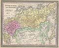
 Map of the territories of Qing Dynasty printed in 1890 by Rand, McNally & Co, (United-States of America)
 -
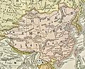
 Map of the Qing Empire by german cartographer en:Adolf Stieler published in 1891
 -
 Map of China, by the british en:Archibald Ross Colquhoun published in 1898
 -
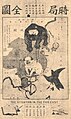
 Map of the Empire with caricature on geopolitics between China and Eight-Nation Alliance around 1900.
 -
 Map of the Qing Dynasty in 1910, China and its dependencies, published by en:Cambridge University Press, in 1912 in en:The Cambridge Modern History Atlas
 -
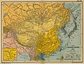
 Map of China and its territories, en:National Geographic Magazine, 1912
 -
Map of the Qing Dynasty Empire published by en:Harvard University Press in 1935, map made by german geographer, en:Albert Herrmann.


- 1892 map
 --Geographyinitiative (留言) 00:14, 26 February 2021 (UTC)

Sources
[编辑]
- @Geographyinitiative: Answer: that "Qing Empire circa 1820 EN" map is poorly made and didn't show Ladakh before 1841 Dogra-Tibetan war as Tibetan territory. The Sakhalin Island (ᠰᠠᡥᠠᠯᡳᠶᠠᠨ ᡠᠯᠠ ᠠᠩᡤᠠ ᡥᠠᡩᠠ) was drawn on 18th century's Manchu maps. Wei Yuan (1794-1857)'s Sheng Wu Ji (聖武記) documented "太祖遣兵四百收瀕海散各部,其島居負險者刳小舟二百往取,庫頁內附,歲貢貂皮,設姓長、鄉長子弟以統之。" Page 461 of "Translation of Old Manchu documents of w:en:yamen of Sanxing Fu-dutong" (三姓副都统衙门满文档案) documented that the Nivkhs (費雅喀人) on the island was ruled by Qing "居住海島之庫頁費雅喀人貢貂,則由三姓副都統衙門派出官兵,前往約定之奇集噶珊收集貢貂並頒賞烏林。如不前來約定之地,則令官兵尋入海島,喚起前來,徵收貂皮並頒賞烏林。" By 1820 there was no evidence showing Qing has ceded those territories to any other states.
For Taiwan please refer to English Wikipedia article w:en:Taiwan under Qing rule and check its references. I'm not here to explain you common knowledges. --173.68.165.114 00:53, 23 December 2020 (UTC)
发起有关File:Qing Dynasty 1820.png的讨论
讨论页是人们讨论如何改善Wikimedia Commons上的内容的地方。您可以使用此页面发起有关如何改进File:Qing Dynasty 1820.png的讨论。