File:1827 Finley Map of Turkey in Europe, Greece and the Balkans - Geographicus - TurkeyEurope-finley-1827.jpg
Jump to navigation
Jump to search

Size of this preview: 467 × 599 pixels. Other resolutions: 187 × 240 pixels | 374 × 480 pixels | 599 × 768 pixels | 798 × 1,024 pixels | 2,339 × 3,000 pixels.
Original file (2,339 × 3,000 pixels, file size: 1.94 MB, MIME type: image/jpeg)
Captions
Captions
Add a one-line explanation of what this file represents
| Anthony Finley: Turkey in Europe.
( |
||||||||||||||
|---|---|---|---|---|---|---|---|---|---|---|---|---|---|---|
| Artist |
|
|||||||||||||
| Title |
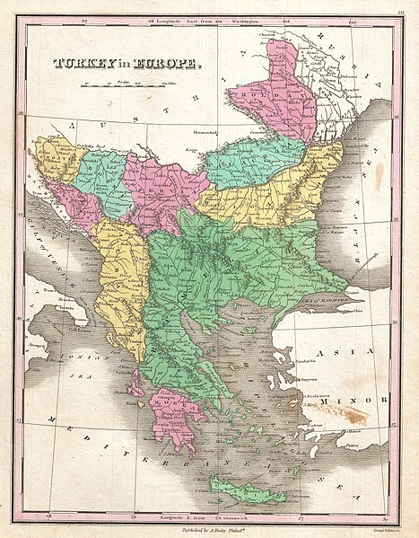
Turkey in Europe. |
|||||||||||||
| Description |
English: A beautiful example of Finley's rare 1827 map of Turkey in Europe. Covers the European lands claimed by the Ottoman Empire in the early 19th century. This includes the modern day nations of Turkey, Greece, Macedonia, Albania, Croatia, Bosnia, Serbia, Montenegro, Bulgaria, Romania and Moldova. In Finley's classic minimalist style, this map identifies cities, forests, river systems, swamps and mountains. Color coded according to regional political boundaries. Title and scale in upper left quadrant. Engraved by Young and Delleker for the 1827 edition of Anthony Finley's General Atlas . |
|||||||||||||
| Date | 1827 (undated) | |||||||||||||
| Dimensions | height: 11.5 in (29.2 cm); width: 9 in (22.8 cm) | |||||||||||||
| Accession number |
Geographicus link: TurkeyEurope-finley-1827 |
|||||||||||||
| Source/Photographer |
Finley, Anthony, A New General Altas, Comprising a Complete Set of Maps, representing the Grand Divisions of the Globe, Together with the several Empires, Kingdoms and States in the World; Compiled from the Best Authorities, and corrected by the Most Recent Discoveries, Philadelphia, 1827.
|
|||||||||||||
| Permission (Reusing this file) |
|
|||||||||||||
| Annotations | This image is annotated: View the annotations at Commons |
File history
Click on a date/time to view the file as it appeared at that time.
| Date/Time | Thumbnail | Dimensions | User | Comment | |
|---|---|---|---|---|---|
| current | 15:35, 16 November 2022 | | 2,339 × 3,000 (1.94 MB) | Gyalu22 (talk | contribs) | Reverted overwriting of artwork |
| 18:45, 8 January 2020 |  | 2,339 × 3,000 (4.01 MB) | Julieta39 (talk | contribs) | Cleaning freckles, contrast. | |
| 10:10, 23 March 2011 |  | 2,339 × 3,000 (1.94 MB) | BotMultichillT (talk | contribs) | {{subst:User:Multichill/Geographicus |link=http://www.geographicus.com/P/AntiqueMap/TurkeyEurope-finley-1827 |product_name=1827 Finley Map of Turkey in Europe, Greece and the Balkans |map_title=Turkey in Europe. |description=A beautiful example of Finley' |
You cannot overwrite this file.
File usage on Commons
The following 2 pages use this file:
File usage on other wikis
The following other wikis use this file:
- Usage on de.wikipedia.org
- Usage on en.wikipedia.org
- Usage on fr.wikipedia.org
- Usage on hr.wikipedia.org
- Usage on it.wikipedia.org
- Usage on ka.wikipedia.org
- Usage on ro.wikipedia.org
- Usage on sh.wikipedia.org
- Usage on sq.wikipedia.org
- Usage on tl.wikipedia.org
- Usage on tr.wikipedia.org