File:1855 Colton Map of Balochistan.jpg
Original file (1,068 × 743 pixels, file size: 275 KB, MIME type: image/jpeg)
Captions
Captions
| Persia, Arabia & Co. | ||||||
|---|---|---|---|---|---|---|
| Artist | ||||||
| Title |
Persia, Arabia & Co. |
|||||
| Description |
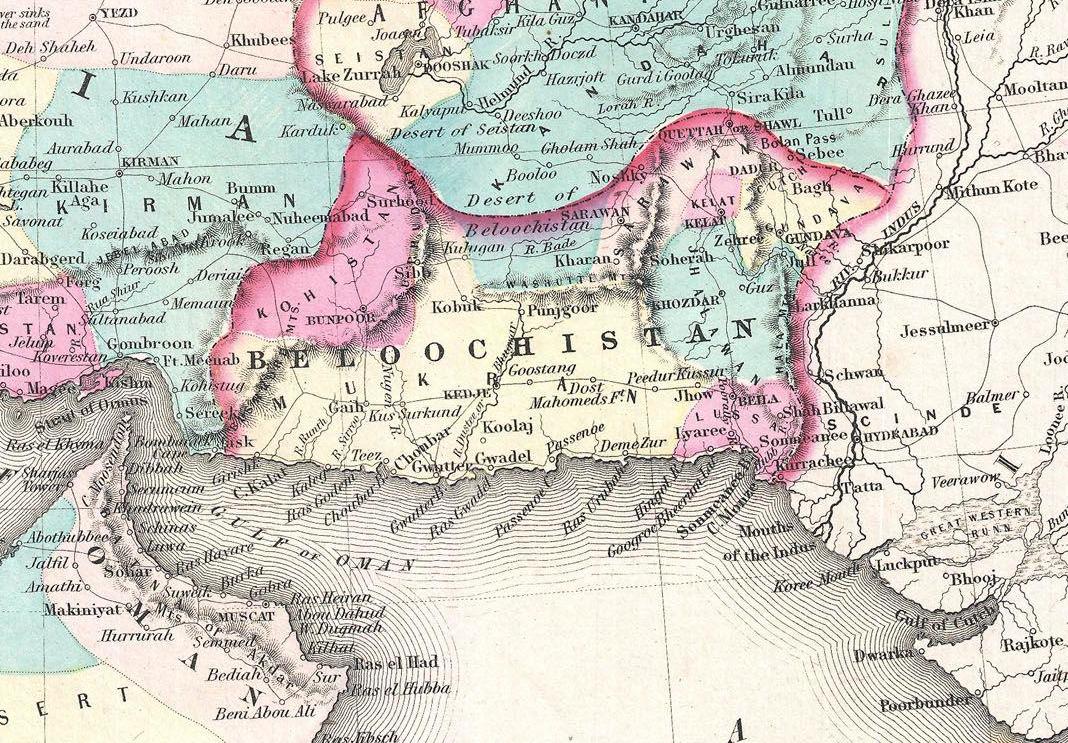
English: A beautiful 1855 first edition example of Colton's map of Persia, Arabia and Afghanistan. Covers from the Mediterranean east to India and south to include all of Arabia to the entrance to the Red Sea. Includes adjacent parts of Egypt, Abyssinia, Turkey, India and Turkistan. In this early edition of the map Afghanistan is divided into Afghanistan and Beloochistan. Later editions unite the provinces and drop Cabool as an alternate name for Afghanistan. Throughout the map, Colton identifies various cities, towns, forts, rivers, desert oases, and an assortment of additional topographical details. Surrounded by Colton's typical spiral motif border. Dated and copyrighted to J. H. Colton, 1855. Published from Colton's 172 William Street Office in New York City. Issued as page no. 27 in volume 2 of the first edition of George Washington Colton's 1855 Atlas of the World . |
|||||
| Date | 1855 (dated) | |||||
| Dimensions | height: 13 in (33 cm); width: 16.5 in (41.9 cm) | |||||
| Accession number |
Geographicus link: PersiaArabia-colton-1855 |
|||||
| Source/Photographer |
Colton, G. W., Colton's Atlas of the World Illustrating Physical and Political Geography, Vol 2, New York, 1855 (First Edition).
|
|||||
| Permission (Reusing this file) |
|
|||||
| Other versions | ||||||

File history
Click on a date/time to view the file as it appeared at that time.
| Date/Time | Thumbnail | Dimensions | User | Comment | |
|---|---|---|---|---|---|
| current | 16:03, 16 August 2020 | | 1,068 × 743 (275 KB) | Mehrwaan (talk | contribs) | File:1855 Colton Map of Persia, Afghanistan, and Arabia - Geographicus - PersiaArabia-colton-1855.jpg cropped 64 % horizontally, 70 % vertically using CropTool with precise mode. |
You cannot overwrite this file.
File usage on Commons
The following 5 pages use this file:
File usage on other wikis
The following other wikis use this file:
- Usage on ar.wikipedia.org
- Usage on ast.wikipedia.org
- Usage on az.wikipedia.org
- Usage on bg.wikipedia.org
- Usage on ca.wikipedia.org
- Usage on cy.wikipedia.org
- Usage on diq.wikipedia.org
- Usage on en.wikipedia.org
- Usage on eo.wikipedia.org
- Usage on fa.wikipedia.org
- Usage on gl.wikipedia.org
- Usage on he.wikipedia.org
- Usage on ko.wikipedia.org
- Usage on lv.wikipedia.org
- Usage on no.wikipedia.org
- Usage on ro.wikipedia.org
- Usage on ru.wikipedia.org
- Usage on uk.wikipedia.org
- Usage on www.wikidata.org