File:Administrative map of Bulgaria during WWII sr.svg
Jump to navigation
Jump to search

Size of this PNG preview of this SVG file: 715 × 461 pixels. Other resolutions: 320 × 206 pixels | 640 × 413 pixels | 1,024 × 660 pixels | 1,280 × 825 pixels | 2,560 × 1,651 pixels.
Original file (SVG file, nominally 715 × 461 pixels, file size: 165 KB)
Captions
Captions
Add a one-line explanation of what this file represents
| Description |
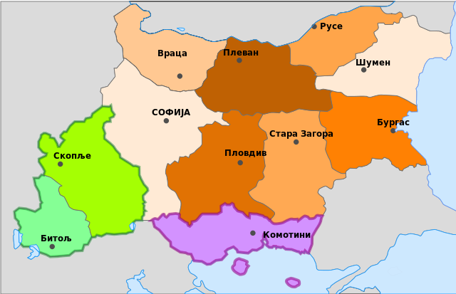
Српски / srpski: Административна подела Бугарске током Другог светског рата. Зеленом су означене територије припојене од Југославије а љубичастом од Грчке
English: Administrative division of Bulgaria during the World War II. |
| Date | |
| Source | Image:Administrative map of Bulgaria during WWII.svg |
| Author | Obradovic Goran |
| Other versions | Original, Macedonian |

|
Permission is granted to copy, distribute and/or modify this document under the terms of the GNU Free Documentation License, Version 1.2 or any later version published by the Free Software Foundation; with no Invariant Sections, no Front-Cover Texts, and no Back-Cover Texts. A copy of the license is included in the section entitled GNU Free Documentation License. |
| This file is licensed under the Creative Commons Attribution-Share Alike 3.0 Unported license. | ||
| ||
| This licensing tag was added to this file as part of the GFDL licensing update. |

|
This SVG file contains embedded text that can be translated into your language, using any capable SVG editor, text editor or the SVG Translate tool. For more information see: About translating SVG files. |
File history
Click on a date/time to view the file as it appeared at that time.
| Date/Time | Thumbnail | Dimensions | User | Comment | |
|---|---|---|---|---|---|
| current | 12:52, 13 June 2008 | | 715 × 461 (165 KB) | Obradovic Goran~commonswiki (talk | contribs) | {{Information |Description={{sr|1=Административна подела Бугарске током Другог светског рата. Зеленом су означене територије припојене од Југославије а � |
You cannot overwrite this file.
File usage on Commons
There are no pages that use this file.
File usage on other wikis
The following other wikis use this file:
- Usage on sh.wikipedia.org
- Usage on sr.wikipedia.org
- Usage on uk.wikipedia.org