File:Allegheny Islands State Park, C.W. Bill Young Lock and Dam.jpg
Jump to navigation
Jump to search
No higher resolution available.
Allegheny_Islands_State_Park,_C.W._Bill_Young_Lock_and_Dam.jpg (720 × 480 pixels, file size: 113 KB, MIME type: image/jpeg)
Captions
Captions
Add a one-line explanation of what this file represents
|
This is an image of a place or building that is listed on the National Register of Historic Places in the United States of America. Its reference number is 397. |
| Description |
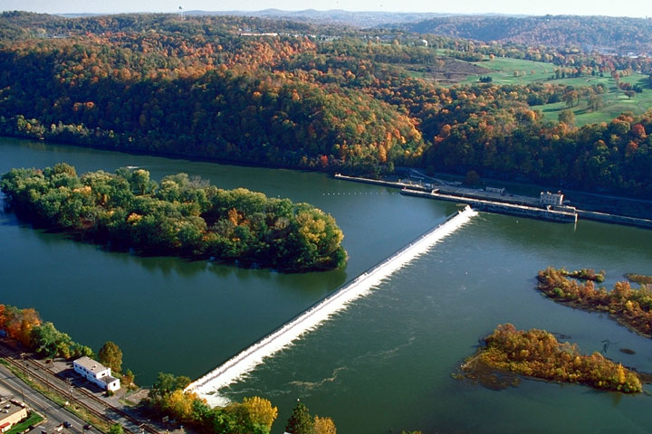
English: Part of Allegheny Islands State Park and the C.W. Bill Young Lock and Dam (Lock and Dam #3) on the Allegheny River, Allegheny County, Pennsylvania, United States. |
|||
| Date | Uploaded August 2007 | |||
| Source | U.S. Army Corps of Engineers website for the C.W. Bill Young Lock and Dam [1] | |||
| Author | U.S. Army Corps of Engineers | |||
| Permission (Reusing this file) |
|
|||
| Location | near Pittsburgh in Harmar Township, Allegheny County, Pennsylvania, USA |
| Object location | | View this and other nearby images on: OpenStreetMap |
|---|
File history
Click on a date/time to view the file as it appeared at that time.
| Date/Time | Thumbnail | Dimensions | User | Comment | |
|---|---|---|---|---|---|
| current | 17:55, 29 August 2007 | | 720 × 480 (113 KB) | Ruhrfisch (talk | contribs) | {{Information | Description = {{en|Part of Allegheny Islands State Park and the C.W. Bill Young Lock and Dam (Lock and Dam #3) on the Allegheny River, Allegheny County, Pennsylvania, United States.}} | Source |
You cannot overwrite this file.
File usage on Commons
The following page uses this file:
File usage on other wikis
The following other wikis use this file:
- Usage on ar.wikipedia.org
- Usage on bg.wikipedia.org
- Usage on ceb.wikipedia.org
- Usage on en.wikipedia.org
- Usage on fa.wikipedia.org
- Usage on fr.wikipedia.org
- Usage on he.wikipedia.org
- Usage on lt.wikipedia.org
- Usage on pl.wikipedia.org
- Usage on tl.wikipedia.org
- Usage on vi.wikipedia.org
- Usage on www.wikidata.org
Metadata
Categories:
- Aerial photographs of Pennsylvania
- Harmar Township, Allegheny County, Pennsylvania
- Dams in Pennsylvania
- Islands of Pennsylvania
- River islands of the United States
- Allegheny Islands State Park
- Geomorphology of Pennsylvania
- Locks on the Allegheny River
- Dams of the Allegheny River
- United States Army Corps of Engineers, Pittsburgh District