File:Anaximander world map-ukr.svg
Jump to navigation
Jump to search

Size of this PNG preview of this SVG file: 600 × 600 pixels. Other resolutions: 240 × 240 pixels | 480 × 480 pixels | 768 × 768 pixels | 1,024 × 1,024 pixels | 2,048 × 2,048 pixels | 1,063 × 1,063 pixels.
Original file (SVG file, nominally 1,063 × 1,063 pixels, file size: 13 KB)
Captions
Captions
Add a one-line explanation of what this file represents
Summary
[edit]| Description |
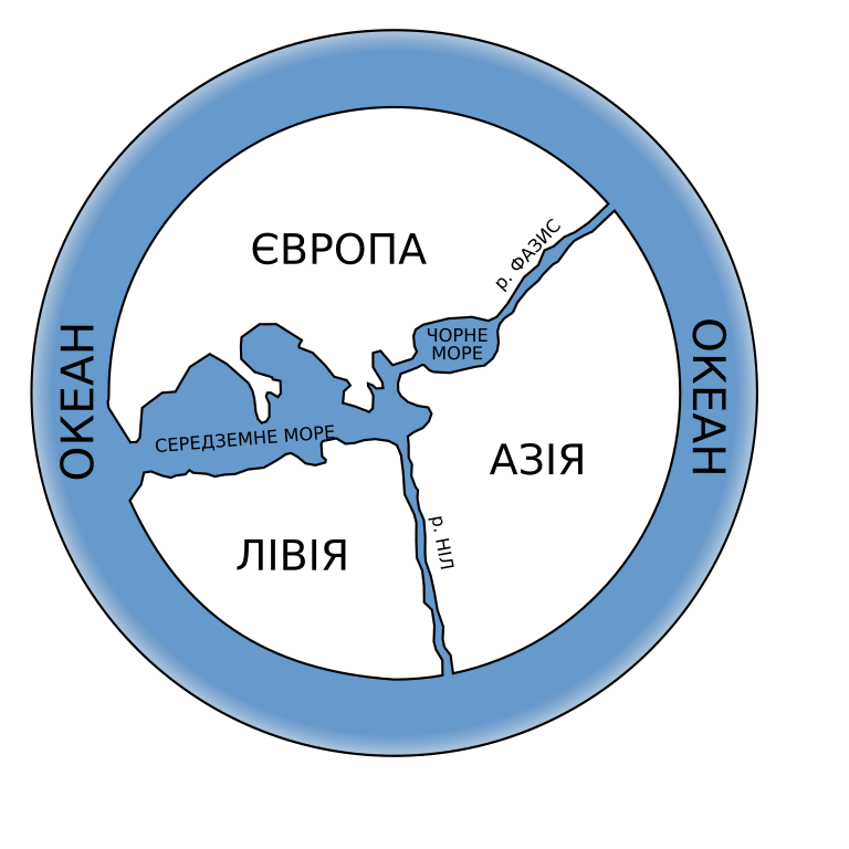
English: Possibly what the lost first map of the world by Anaximander looked like.
Українська: Мапа Анаксімандра |
||
| Date | |||
| Source | Own work (Ukrainian translation of File:Anaximander world map-en.svg). | ||
| Author | User:Bibi Saint-Pol (original file); Vity OKM (Ukrainian translation) | ||
| Permission (Reusing this file) |
|
||
| Other versions |
[]
|


|
This SVG file contains embedded text that can be translated into your language, using any capable SVG editor, text editor or the SVG Translate tool. For more information see: About translating SVG files. |
File history
Click on a date/time to view the file as it appeared at that time.
| Date/Time | Thumbnail | Dimensions | User | Comment | |
|---|---|---|---|---|---|
| current | 23:44, 30 November 2017 | | 1,063 × 1,063 (13 KB) | Vity OKM (talk | contribs) | User created page with UploadWizard |
You cannot overwrite this file.
File usage on Commons
The following 44 pages use this file:
- File:Anaximander world map-ar.svg
- File:Anaximander world map-bn.svg
- File:Anaximander world map-ca.svg
- File:Anaximander world map-da.svg
- File:Anaximander world map-de.svg
- File:Anaximander world map-dty.svg
- File:Anaximander world map-el.svg
- File:Anaximander world map-en.svg
- File:Anaximander world map-eo.svg
- File:Anaximander world map-es.svg
- File:Anaximander world map-fa.svg
- File:Anaximander world map-fr.svg
- File:Anaximander world map-gu.svg
- File:Anaximander world map-he.svg
- File:Anaximander world map-hi.svg
- File:Anaximander world map-hr.PNG
- File:Anaximander world map-hr.svg
- File:Anaximander world map-hu.svg
- File:Anaximander world map-it.svg
- File:Anaximander world map-ja.svg
- File:Anaximander world map-ka.svg
- File:Anaximander world map-kn.svg
- File:Anaximander world map-ko.svg
- File:Anaximander world map-lt.svg
- File:Anaximander world map-ml.svg
- File:Anaximander world map-mr.svg
- File:Anaximander world map-ne.svg
- File:Anaximander world map-nl.svg
- File:Anaximander world map-or.svg
- File:Anaximander world map-pa.svg
- File:Anaximander world map-pl.svg
- File:Anaximander world map-pt.svg
- File:Anaximander world map-ro.svg
- File:Anaximander world map-ru.svg
- File:Anaximander world map-ru bxr.svg
- File:Anaximander world map-ta.svg
- File:Anaximander world map-te.svg
- File:Anaximander world map-th.svg
- File:Anaximander world map-tr.svg
- File:Anaximander world map-ukr.svg
- File:Anaximander world map-zh.svg
- File:Anaximander world map as.svg
- File:First map of the world according to Anaximander (6th century BC).svg
- Template:Other versions/Anaximander world map
.svg)
File usage on other wikis
The following other wikis use this file:
- Usage on uk.wikipedia.org