File:Arcole campaign first phase.svg

File originale (file in formato SVG, dimensioni nominali 1 156 × 1 044 pixel, dimensione del file: 506 KB)
Didascalie
Didascalie
Dettagli
[modifica]| Descrizione |
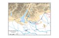
English: Map shows the first phase of the Arcole campaign, after the battles of San Michele, 2nd Bassano, and Calliano
|
||||||||||||||||||||||||
| Data | |||||||||||||||||||||||||
| Fonte |
Opera propria basata su: Information from: |
||||||||||||||||||||||||
| Autore | Goran_tek-en | ||||||||||||||||||||||||
| Licenza (Riusare questo file) |
Questo file è disponibile in base alla licenza Creative Commons Attribuzione-Condividi allo stesso modo 4.0 Internazionale Attribuzione: Goran tek-en
|
||||||||||||||||||||||||
| Altre versioni |
|
||||||||||||||||||||||||
| SVG sviluppo | Questa grafica vettoriale è stata creata con Inkscape. |
||||||||||||||||||||||||


| Posizione del soggetto | | Posizione di questa e altre immagini su: OpenStreetMap |
|---|


Cronologia del file
Fare clic su un gruppo data/ora per vedere il file come si presentava nel momento indicato.
| Data/Ora | Miniatura | Dimensioni | Utente | Commento | |
|---|---|---|---|---|---|
| attuale | 11:34, 20 nov 2021 | | 1 156 × 1 044 (506 KB) | Goran tek-en (discussione | contributi) | {{Information |description ={{en|Map shows the first phase of the Arcole campaign, after the battles of San Michele, 2nd Bassano, and Calliano}} {{Institution |wikidata=Q18817}} {{Institution |wikidata=Q7818}} |date =2021-11-20 |source ={{Own}}<br> {{Derived from|Nap07.pdf|Siege of Mantua Campaign Map 1796 1797.JPG|Arcole 1796 Campaign Map.jpg|Maps template-en.svg|Template of Military Symbols.svg|BlankMap-World gray.svg}} Derived from; *[https://www.openstreetmap.org... |
Impossibile sovrascrivere questo file.
Utilizzo del file
Le seguenti 2 pagine usano questo file:
Utilizzo globale del file
Anche i seguenti wiki usano questo file:
- Usato nelle seguenti pagine di en.wikipedia.org:
- Usato nelle seguenti pagine di it.wikipedia.org:
- Usato nelle seguenti pagine di ka.wikipedia.org: