File:ArmeniaSevres.gif
Jump to navigation
Jump to search

Size of this preview: 800 × 526 pixels. Other resolutions: 320 × 211 pixels | 640 × 421 pixels | 1,024 × 674 pixels | 1,280 × 842 pixels | 2,245 × 1,477 pixels.
Original file (2,245 × 1,477 pixels, file size: 298 KB, MIME type: image/gif)
Captions
Captions
Add a one-line explanation of what this file represents
Summary[edit]
| Description |
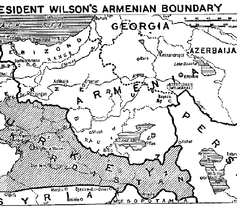
English: Map of Eastern Turkey, showing the extent of Turkish Armenia according to President Wilson's boundary decision in Treaty of Sèvres. |
| Date | |
| Source | http://www.gwpda.org/gifs/armenia.gif |
| Author | Lt. Colonel Lawrence Martin. Geographer of the Institute of Politics at Williamstown, Mass, 1921-27 |
Licensing[edit]
This media file is in the public domain in the United States. This applies to U.S. works where the copyright has expired, often because its first publication occurred prior to January 1, 1929, and if not then due to lack of notice or renewal. See this page for further explanation.
|
 | |
 |
This image might not be in the public domain outside of the United States; this especially applies in the countries and areas that do not apply the rule of the shorter term for US works, such as Canada, Mainland China (not Hong Kong or Macao), Germany, Mexico, and Switzerland. The creator and year of publication are essential information and must be provided. See Wikipedia:Public domain and Wikipedia:Copyrights for more details.
|
File history
Click on a date/time to view the file as it appeared at that time.
| Date/Time | Thumbnail | Dimensions | User | Comment | |
|---|---|---|---|---|---|
| current | 07:05, 30 June 2021 | | 2,245 × 1,477 (298 KB) | Zero0000 (talk | contribs) | Higher resolution and more of the original. |
| 18:15, 30 June 2012 |  | 785 × 685 (30 KB) | Infestor (talk | contribs) |
You cannot overwrite this file.
File usage on Commons
There are no pages that use this file.
File usage on other wikis
The following other wikis use this file:
- Usage on ar.wikipedia.org
- Usage on azb.wikipedia.org
- Usage on az.wikipedia.org
- Usage on fa.wikipedia.org
- Usage on hy.wikipedia.org
- Usage on ro.wikipedia.org
- Usage on tr.wikipedia.org
- Usage on zh.wikipedia.org