File:Austria (orthographic projection).svg
Jump to navigation
Jump to search

Size of this PNG preview of this SVG file: 600 × 600 pixels. Other resolutions: 240 × 240 pixels | 480 × 480 pixels | 768 × 768 pixels | 1,024 × 1,024 pixels | 2,048 × 2,048 pixels | 792 × 792 pixels.
Original file (SVG file, nominally 792 × 792 pixels, file size: 5.22 MB)
Captions
Captions
Add a one-line explanation of what this file represents
Summary[edit]
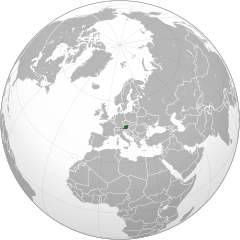
| Description |
English: Orthographic Projection Map of Austria |
||
| Date | |||
| Source | Germany (orthographic projection).svg by The Emirr | ||
| Author | NordNordWest | ||
| Other versions |
.svg)
|
.svg)
.svg)
.svg)
.svg)
.svg)
.svg)
.svg)
.svg)
.svg)
.svg)
.svg)
.svg)
.svg)
.svg)
.svg)
.svg)
.svg)
.svg)
.svg)
.svg)
.svg)
.svg)
.svg)
.svg)
.svg)
.svg)
.svg)
.svg)
.svg)
.svg)
.svg)
.svg)
.svg)
.svg)
.svg)
.svg)
.svg)
.svg)
.svg)
.svg)
.svg)
.svg)
.svg)
.svg)
.svg)
.svg)
.svg)
.svg)
.svg)
.svg)
.svg)
.svg)
.svg)
.svg)
.svg)
.svg)
.svg)
.svg)
.svg)
.svg)
.svg)
.svg)
.svg)
.svg)
.svg)
.svg)
.svg)
.svg)
.svg)
.svg)
.svg)
.svg)
.svg)

.svg)

.svg)

.svg)
.svg)
.svg)
.svg)
.svg)
.svg)
.svg)


.svg)
.svg)
.svg)
.svg)
.svg)
.svg)
.svg)

.svg)
.svg)
.svg)
.svg)
.svg)
.svg)
.svg)
.svg)
.svg)

.svg)
.svg)
.svg)
.svg)
.svg)
.svg)
.svg)
_without_national_boundaries.svg)
.svg)
.svg)
.svg)
.svg)
.svg)
.svg)

.svg)
.svg)
.png)
.svg)
.svg)
.svg)
.svg)

.svg)
.svg)
.svg)
.svg)
.svg)
.svg)
.svg)
.svg)
.svg)
.svg)
.svg)

.svg)
.svg)
.svg)
.svg)
.svg)
.svg)
.svg)
.svg)
.svg)

.svg)
.svg)

.svg)
.svg)
.svg)
.svg)
.svg)
.svg)
.svg)
.svg)
.svg)
.svg)
.svg)
.svg)
.svg)
.svg)
.svg)
.svg)
.svg)
.svg)
.svg)
.svg)
.svg)
.svg)
.svg)
.svg)
.svg)
.svg)
.svg)
_-_Crimea_disputed.svg)
.svg)
.svg)
.svg)
.svg)
.svg)
.svg)
.svg)
.svg)
.svg)
.svg)
.svg)
_political.svg)
.svg)
.svg)
.svg)
.svg)
_-_Crimea_disputed_-_no_borders.svg)
.svg)
.svg)
.svg)
.svg)
.svg)
.svg)
.svg)
.svg)
.svg)
.svg)
.svg)

.svg)
.svg)
.svg)

.png)
.svg)
.svg)
.svg)
.svg)
.svg)
.svg)
.svg)
.svg)
.svg)
.svg)
.svg)
.svg)
.svg)
.svg)
.svg)
.svg)
.svg)
.svg)
.svg)
.svg)
.svg)
.svg)
.svg)
.svg)
.svg)
.svg)
.svg)
.svg)
.svg)
.svg)
.svg)
.svg)
.svg)
.svg)
.png)
.svg)
.svg)
.svg)
_(orthographic_projection).png)
.svg&action=edit§ion=1)
.svg)
.svg)
Licensing[edit]
.svg&action=edit§ion=2)
| This work is ineligible for copyright and therefore in the public domain because it consists entirely of information that is common property and contains no original authorship. |
File history
Click on a date/time to view the file as it appeared at that time.
| Date/Time | Thumbnail | Dimensions | User | Comment | |
|---|---|---|---|---|---|
| current | 13:31, 25 August 2018 | | 792 × 792 (5.22 MB) | NordNordWest (talk | contribs) | {{Information |Description={{en|1=Orthographic Projection Map of Austria}} |Source={{f|Germany (orthographic projection).svg}} by {{U|The Emirr}} |Author={{U|NordNordWest}} |Date=2018-08-25 |Permission= |other_versions={{User:Ssolbergj/orthographic}} }} == {{int:license-header}} == {{PD-ineligible}} Category:SVG locator maps of countries of Europe (green and grey globe scheme) |
You cannot overwrite this file.
File usage on Commons
The following page uses this file:
File usage on other wikis
The following other wikis use this file:
- Usage on de.wikipedia.org
- Usage on en.wikinews.org
- Wikinews:Template messages/Infoboxes/Countries
- Template:Austria
- Two killed, high damages as storm hits Vienna, Austria
- Austrian man kept daughter prisoner in cellar for 24 years
- Police: Austrian children kept in dungeon were in 'oppressive' conditions
- Trial date scheduled for Austrian man who kept his daughter in a dungeon for 24 years
- Austrian man who imprisoned daughter pleads guilty at start of trial
- Austrian police find dozens dead inside lorry
- Four men go before Hungarian court after 71 found dead in lorry
- Former Miss Austria Ena Kadic dies after mountain fall
- Template:Infobox/lookup/Austria
- Usage on es.wikipedia.org
- Usage on he.wikipedia.org
- Usage on id.wikipedia.org
- Usage on incubator.wikimedia.org
- Usage on pl.wikipedia.org
- Usage on pt.wikinews.org
- Príncipe Johan Friso da Holanda segue em estado crítico
- Predefinição:Infotabela Áustria
- Galeria de Fotos: Skispringen 2015 em Hinzenbach, Áustria
- Galeria de Fotos: Apresentação da Premiação no Cinema Austríaco 2015
- Áustria relembra os 70 anos da libertação de campo de concentração Auschwitz
- Eleição presidencial na Áustria deve ser repetido
- Autoridades austríacas pretendem proibir vestes de burca e o niqab em lugares públicos
- Áustria: russo é morto a tiros
- Áustria suspenderá a proibição de voos da Rússia a partir de 1 de agosto
- Áustria expulsa diplomata russo
- Austríaco bate recorde de permanência em cabine com gelo
- Covid-19: Áustria anuncia bloqueio parcial de 4 semanas a partir de terça-feira
- Atentados terroristas deixam mortos e feridos na Áustria
- Terrorismo: ataque em Viena deixou 5 mortos
- Áustria reconhece erros na tentativa de prevenir ataques terroristas
- Covid-19: Áustria vai receber doentes portugueses que precisam de cuidados intensivos
- Covid-19: estudo austríaco demonstra que maioria dos infectados mantêm imunidade
- Áustria anunciou a expulsão de quatro diplomatas russos
- Câmara aprova acordo de extradição com a Áustria
- Alexander Van der Bellen provavelmente foi eleito presidente da Áustria para um segundo mandato
- Usage on sr.wikipedia.org
.svg&oldid=808254318)