File:Azimuth-Altitude schematic.svg
Jump to navigation
Jump to search

Size of this PNG preview of this SVG file: 436 × 420 pixels. Other resolutions: 249 × 240 pixels | 498 × 480 pixels | 797 × 768 pixels | 1,063 × 1,024 pixels | 2,126 × 2,048 pixels.
Original file (SVG file, nominally 436 × 420 pixels, file size: 182 KB)
Captions
Captions
Add a one-line explanation of what this file represents
Summary
[edit]| Description |
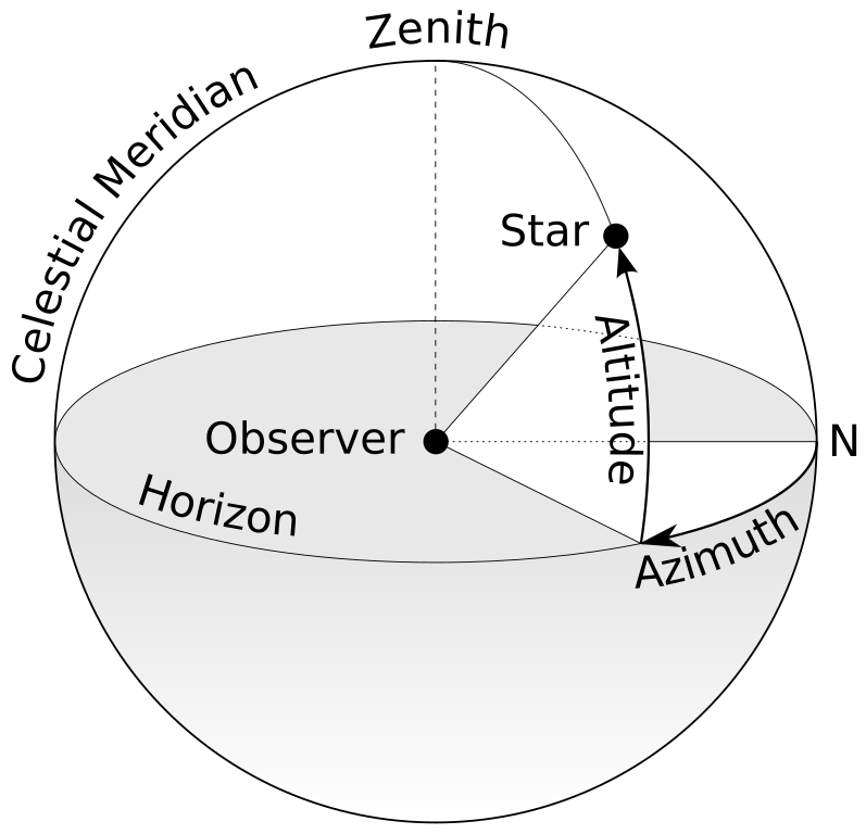
English: A schematic diagram of the terms "Azimuth" and "Altitude" as they relate to the viewing of celestial objects. |
| Source | Azimut altitude.svg |
| Author | TWCarlson |
| Other versions |
[]
|
| SVG development | This diagram was created with Adobe Illustrator, and with Inkscape. This diagram uses embedded text that can be easily translated using a text editor. |


Licensing
[edit]
I, the copyright holder of this work, hereby publish it under the following licenses:
This file is licensed under the Creative Commons Attribution-Share Alike 3.0 Unported license.
- You are free:
- to share – to copy, distribute and transmit the work
- to remix – to adapt the work
- Under the following conditions:
- attribution – You must give appropriate credit, provide a link to the license, and indicate if changes were made. You may do so in any reasonable manner, but not in any way that suggests the licensor endorses you or your use.
- share alike – If you remix, transform, or build upon the material, you must distribute your contributions under the same or compatible license as the original.

|
Permission is granted to copy, distribute and/or modify this document under the terms of the GNU Free Documentation License, Version 1.2 or any later version published by the Free Software Foundation; with no Invariant Sections, no Front-Cover Texts, and no Back-Cover Texts. A copy of the license is included in the section entitled GNU Free Documentation License. |
You may select the license of your choice.
File history
Click on a date/time to view the file as it appeared at that time.
| Date/Time | Thumbnail | Dimensions | User | Comment | |
|---|---|---|---|---|---|
| current | 10:02, 7 March 2020 | | 436 × 420 (182 KB) | عبد الجليل 09 (talk | contribs) | File uploaded using svgtranslate tool (https://tools.wmflabs.org/svgtranslate/). Added translation for es. |
| 11:33, 7 May 2012 |  | 436 × 420 (189 KB) | TWCarlson (talk | contribs) | Reversed image and re-placed text to show proper clockwise direction for measuring azimuth. | |
| 14:09, 19 December 2011 |  | 424 × 419 (182 KB) | TWCarlson (talk | contribs) | Minor changes | |
| 14:05, 19 December 2011 |  | 424 × 419 (182 KB) | TWCarlson (talk | contribs) | Minor changes | |
| 13:54, 19 December 2011 |  | 424 × 419 (182 KB) | TWCarlson (talk | contribs) | Various changes | |
| 13:48, 19 December 2011 |  | 442 × 419 (142 KB) | TWCarlson (talk | contribs) | {{Information |Description ={{en|1=A schematic diagram of the terms "Azimuth" and "Altitude" as they relate to the viewing of celestial objects.}} |Source =http://commons.wikimedia.org/wiki/File:Azimut_altitude.svg |Author =[[User:TWCar |
You cannot overwrite this file.
File usage on Commons
The following 13 pages use this file:
- File:Azimut altitude-ar.svg
- File:Azimuth-Altitude schematic-ta.svg
- File:Azimuth-Altitude schematic.svg
- File:Azimuth-Altitude schematic (ar).png
- File:Azimuth-Altitude schematic el.svg
- File:Azimuth-Altitude schematic es.svg
- File:Azimuth-Altitude schematic it.svg
- File:Azimuth-Altitude schematic mk.svg
- File:Azimuth-Altitude schematic no.svg
- File:Azimuth-Altitude schematic sr.svg
- File:Azimuth schematic bg.svg
- Template:Other versions/Azimuth-Altitude schematic
- Category:Horizontal coordinate system
.png)
File usage on other wikis
The following other wikis use this file:
- Usage on ast.wikipedia.org
- Usage on ckb.wikipedia.org
- Usage on de.wikipedia.org
- Usage on el.wikipedia.org
- Usage on en.wikipedia.org
- Usage on en.wikibooks.org
- Usage on en.wikiversity.org
- Usage on en.wiktionary.org
- Usage on eu.wikipedia.org
- Usage on fa.wikipedia.org
- Usage on fi.wikipedia.org
- Usage on fi.wiktionary.org
- Usage on ga.wikipedia.org
- Usage on hi.wikipedia.org
- Usage on ig.wikipedia.org
- Usage on ka.wikipedia.org
- Usage on kbd.wiktionary.org
- Usage on mdf.wikipedia.org
- Usage on ml.wikipedia.org
- Usage on mn.wikipedia.org
- Usage on ms.wikipedia.org
- Usage on ps.wikipedia.org
- Usage on pt.wikipedia.org
- Usage on ro.wikipedia.org
- Usage on sh.wikipedia.org
- Usage on sv.wikipedia.org
- Usage on ta.wiktionary.org
- Usage on te.wikibooks.org
- Usage on tr.wiktionary.org
- Usage on ur.wikipedia.org
View more global usage of this file.