File:Ball's Pyramid2.jpg
Bước tới điều hướng
Bước tới tìm kiếm
Không có độ phân giải cao hơn.
Ball's_Pyramid2.jpg (317×356 điểm ảnh, kích thước tập tin: 22 kB, kiểu MIME: image/jpeg)
Chú thích
Chú thích
Ghi một dòng giải thích những gì có trong tập tin này
Miêu tả[sửa]
| Miêu tả |
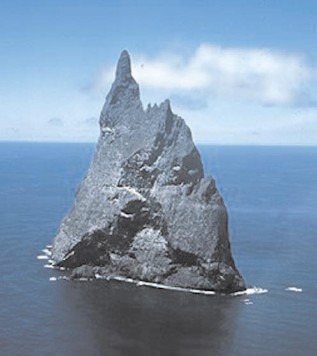
English: Aerial view of Ball’s Pyramid, Lord Howe Island Group, NSW, Australia |
| Ngày | not specified |
| Nguồn gốc | http://pollux.nss.nima.mil/NAV_PUBS/SD/Pub127/, page 105 (jpg extracted from pdf document) |
| Tác giả | National Imagery and Mapping Agency (NIMA), now National Geospatial-Intelligence Agency |
Giấy phép[sửa]
This image is a work of the United States National Geospatial-Intelligence Agency or one of its predecessor agencies. As a work of the U.S. federal government, the image is in the public domain.
|
 |
Nhật trình tải lên đầu tiên[sửa]
(All user names refer to en.wikipedia)
- 2006-02-25 21:36 Ratzer 317×356 (22022 bytes) (http://pollux.nss.nima.mil/NAV_PUBS/SD/Pub127/, page 105 (jpg extracted from pdf document))
Lịch sử tập tin
Nhấn vào ngày/giờ để xem nội dung tập tin tại thời điểm đó.
| Ngày/Giờ | Hình xem trước | Kích cỡ | Thành viên | Miêu tả | |
|---|---|---|---|---|---|
| hiện tại | 19:08, ngày 21 tháng 8 năm 2006 | | 317×356 (22 kB) | Liftarn (thảo luận | đóng góp) | {{Information| |Description=Ball's Pyramid |Source=http://pollux.nss.nima.mil/NAV_PUBS/SD/Pub127/, page 105 (jpg extracted from pdf document) |Date= |Author=User Ratzer on [http://en.wikipedia.org en.wikipedia] |Permission={{PD-USGov}} |
Bạn không được phép ghi đè tập tin này.
Trang sử dụng tập tin
Trang sau sử dụng tập tin này:
Sử dụng tập tin toàn cục
Những wiki sau đang sử dụng tập tin này:
- Trang sử dụng tại ar.wikipedia.org
- Trang sử dụng tại az.wikipedia.org
- Trang sử dụng tại be.wikipedia.org
- Trang sử dụng tại bg.wikipedia.org
- Trang sử dụng tại cs.wikipedia.org
- Trang sử dụng tại de.wikipedia.org
- Trang sử dụng tại el.wikipedia.org
- Trang sử dụng tại en.wikipedia.org
- Trang sử dụng tại es.wikipedia.org
- Trang sử dụng tại frr.wikipedia.org
- Trang sử dụng tại fy.wikipedia.org
- Trang sử dụng tại he.wikipedia.org
- Trang sử dụng tại hr.wikipedia.org
- Trang sử dụng tại hu.wikipedia.org
- Trang sử dụng tại hyw.wikipedia.org
- Trang sử dụng tại id.wikipedia.org
- Trang sử dụng tại it.wikipedia.org
- Trang sử dụng tại ka.wikipedia.org
- Trang sử dụng tại ksh.wikipedia.org
- Trang sử dụng tại ky.wikipedia.org
- Trang sử dụng tại lt.wikipedia.org
- Trang sử dụng tại ms.wikipedia.org
- Trang sử dụng tại nn.wikipedia.org
- Trang sử dụng tại no.wikipedia.org
- Trang sử dụng tại pl.wikipedia.org
- Trang sử dụng tại pt.wikipedia.org
- Trang sử dụng tại ru.wikipedia.org
- Trang sử dụng tại sh.wikipedia.org
Xem thêm các trang toàn cục sử dụng tập tin này.