File:Banatia.png
Jump to navigation
Jump to search
Size of this preview: 774 × 600 pixels. Other resolutions: 310 × 240 pixels | 619 × 480 pixels | 1,000 × 775 pixels.
Original file (1,000 × 775 pixels, file size: 74 KB, MIME type: image/png)
Captions
Captions
Add a one-line explanation of what this file represents
Summary[edit]
| Description |
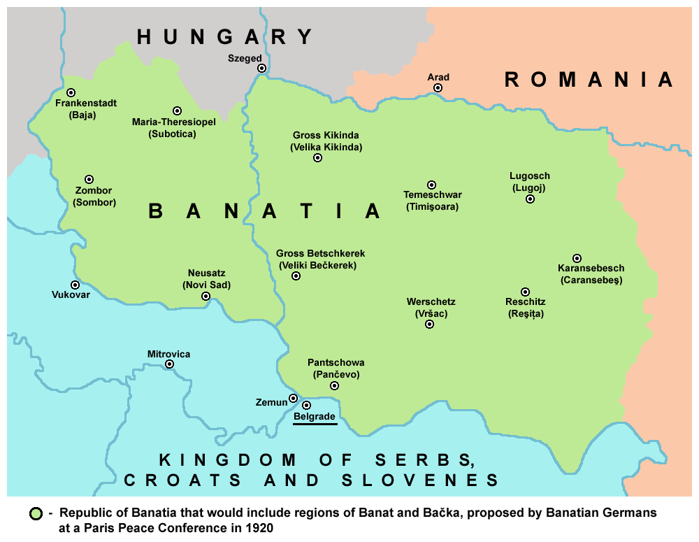
English: Map of the proposed Republic of Banatia (proposed by Banatian Germans at a Paris Peace Conference in 1920).
Српски / srpski: Мапа предложене Републике Банатије (предлог су изнели Немци из Баната на Мировној конференцији у Паризу 1920. године). |
| Date | 29 June 2009 (original upload date) |
| Source | Own work |
| Author | PANONIAN |
| Other versions | Magyar svg |
References[edit]
Info about this proposed state could be found in this book:
- Milojko Brusin, Naša razgraničenja sa susedima 1919-1920, Novi Sad, 1998.
Податак о овој предложеној држави може се пронаћи у следећој књизи:
- Милојко Брусин, Наша разграничења са суседима 1919-1920, Нови Сад, 1998.
Licensing[edit]
self made map by user:PANONIAN
| I, the copyright holder of this work, release this work into the public domain. This applies worldwide. In some countries this may not be legally possible; if so: I grant anyone the right to use this work for any purpose, without any conditions, unless such conditions are required by law. |
File history
Click on a date/time to view the file as it appeared at that time.
| Date/Time | Thumbnail | Dimensions | User | Comment | |
|---|---|---|---|---|---|
| current | 22:19, 18 May 2014 | | 1,000 × 775 (74 KB) | PANONIAN (talk | contribs) | aesthetics |
| 13:26, 29 June 2009 |  | 998 × 775 (74 KB) | PANONIAN (talk | contribs) | ==Description== * '''English''': map of the proposed state of Banatia (proposed by Banatian Germans at a Paris Peace Conference in 1920) * '''Serbian''': мапа предложене државе Банатије (предлог су изнели Нем� |
You cannot overwrite this file.
File usage on Commons
The following 4 pages use this file:
File usage on other wikis
The following other wikis use this file:
- Usage on ar.wikipedia.org
- Usage on ba.wikipedia.org
- Usage on be-tarask.wikipedia.org
- Usage on be.wikipedia.org
- Usage on bn.wikipedia.org
- Usage on bs.wikipedia.org
- Usage on ca.wikipedia.org
- Usage on en.wikipedia.org
- Usage on eo.wikipedia.org
- Usage on es.wikipedia.org
- Usage on eu.wikipedia.org
- Usage on fr.wikipedia.org
- Usage on gl.wikipedia.org
- Usage on hr.wikipedia.org
- Usage on lt.wikipedia.org
- Usage on mk.wikipedia.org
- Usage on ru.wikipedia.org
- Usage on sh.wikipedia.org
- Usage on www.wikidata.org