File:Barentsz arctic map.jpg
Barentsz_arctic_map.jpg (650 × 517 pixel, dimensione del file: 102 KB, tipo MIME: image/jpeg)
Didascalie
Didascalie
Dettagli[modifica]
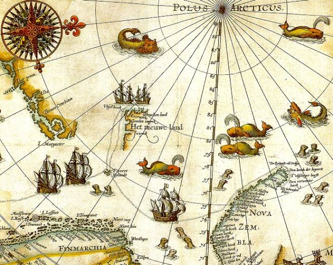
| Descrizione | Portion of 1598 map of Arctic exploration by Willem Barentsz. Spitsbergen, here mapped for the first time, is indicated as "Het Nieuwe Land" (Dutch for "the New Land"), center-left. |
| Data | 1598, misdated to 1599 for no stated reason but possibly a 2nd edition or reprint |
| Fonte | Northern Lights Route project at the University Library of Tromsø, from an original print based on Barentsz's charts |
| Autore | Original charts by Willem Barentsz, drawn by Cornelis Claesz, engraved by Baptista van Doetecum |
| Licenza (Riusare questo file) |
Public domain (over 70 years since creator's death) |
| Altre versioni |
|
.jpg)


_door_Willem_Barendsz_(titel_op_object),_NG-800.jpg)
Licenza[modifica]
|
Quest'opera è nel pubblico dominio anche in tutti i Paesi e nelle aree in cui la durata del copyright è la vita dell'autore più 70 anni o meno.
| |
| Questo file è stato identificato come libero da restrizioni conosciute riguardanti le leggi sul copyright, compresi tutti i diritti connessi e vicini. | |
Cronologia del file
Fare clic su un gruppo data/ora per vedere il file come si presentava nel momento indicato.
| Data/Ora | Miniatura | Dimensioni | Utente | Commento | |
|---|---|---|---|---|---|
| attuale | 09:14, 26 lug 2006 | | 650 × 517 (102 KB) | TheGrappler (discussione | contributi) | {{Information |Description=Portion of 1599 map of Arctic exploration by Willem Barentsz. Spitsbergen, here mapped for the first time, is indicated as "Het Nieuwe Land" (Dutch for "the New Land"), center-left. |Source=[http://www.ub.uit.no/northernlights/e |
Impossibile sovrascrivere questo file.
Utilizzo del file
Le seguenti 10 pagine usano questo file:
- Arctic
- Atlas of Svalbard
- File:1598 map of the Polar Regions by Willem Barentsz.jpg
- File:Barents third voyage.jpg
- File:Barentskartet, 1598 (12068020364).jpg
- File:Barentsz Full Map.jpg
- File:Forminsket utgave av Barentskartet - no-nb krt 00487.jpg
- File:Kaart van de landen rond de poolcirkel met de drie reizen van de Nederlanders, 1598 Beschrijvinghe van de drie seylagien door de Hollanders gedaen ande Noordt syde van Noorweghen, Moscovia, nova Sembla, ende door het de, RP-P-OB-80.320.jpg
- File:Kaart van het Noordpoolgebied, 1598 Beschrijvinghe van de drie seylagien door de Hollanders gedaan (..) door Willem Barendsz (titel op object), NG-800.jpg
- File:Pontanus 1611 Arctic Map.jpg
Utilizzo globale del file
Anche i seguenti wiki usano questo file:
- Usato nelle seguenti pagine di arz.wikipedia.org:
- Usato nelle seguenti pagine di ast.wikipedia.org:
- Usato nelle seguenti pagine di ca.wikipedia.org:
- Usato nelle seguenti pagine di de.wikipedia.org:
- Usato nelle seguenti pagine di el.wikipedia.org:
- Usato nelle seguenti pagine di en.wikipedia.org:
- Usato nelle seguenti pagine di es.wikipedia.org:
- Usato nelle seguenti pagine di fa.wikipedia.org:
- Usato nelle seguenti pagine di fr.wikipedia.org:
- Usato nelle seguenti pagine di id.wikipedia.org:
- Usato nelle seguenti pagine di it.wikipedia.org:
- Usato nelle seguenti pagine di ja.wikipedia.org:
- Usato nelle seguenti pagine di la.wikipedia.org:
- Usato nelle seguenti pagine di no.wikipedia.org:
- Usato nelle seguenti pagine di ru.wikipedia.org:
- Usato nelle seguenti pagine di uk.wikipedia.org:
Metadati
- Historical maps of Spitsbergen
- Old maps of the Arctic
- Old maps of Svalbard
- Third voyage of Willem Barentsz
- 16th-century maps of the Arctic
- 1598 maps
- Latin-language maps
- Dutch-language maps
- Maps of Novaya Zemlya
- Seals in art
- Whales on maps
- Ships on maps
- Monsters on maps
- Compass roses on maps
- Baptista van Doetecum
- Maps of the North Pole
- Cornelis Claesz
- Reindeer sleds in art
- 16th-century maps of Europe