File:Bush Barrow - geograph.org.uk - 1622275.jpg
Bush_Barrow_-_geograph.org.uk_-_1622275.jpg (640 × 480 pixel, dimensione del file: 76 KB, tipo MIME: image/jpeg)
Didascalie
Didascalie
Dettagli[modifica]
| Descrizione |
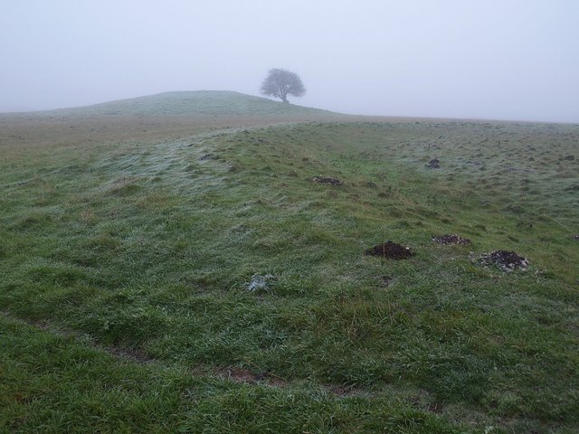
English: Bush Barrow "In the 1720s William Stukeley had called it the bush barrow after trees planted on the top (though the county people knew it as the green barrow)" http://www.britarch.ac.uk/ba/ba104/feat1.shtml .
"This very large bowl barrow in the Normanton Down barrow group, just south of Stonehenge, measures over 40m in diameter and stands today 3m high. It was excavated in 1808 by William Cunnington and Sir Richard Colt Hoare. The primary burial was of a tall, stout, adult man, buried lying on his back. The grave goods placed with him show that this was a princely burial from about 1900 -1700 B.C. It is Britain's richest and most important Bronze Age burial" http://www.wiltshireheritage.org.uk/galleries/index.php?Action=3&obID=89&prevID=9 . In the foreground is a round barrow. Together they form part of the Normanton Down Barrows. The first link gives much detail about the excavation of Bush Barrow and the site as a whole. |
| Data | |
| Fonte | From geograph.org.uk |
| Autore | Derek Harper |
| Attribuzione (richiesto dalla licenza) | Derek Harper / Bush Barrow / |
| Luogo dello scatto | | Posizione di questa e altre immagini su: OpenStreetMap |
|---|
_heading:112.00&language=it)
| Posizione del soggetto | | Posizione di questa e altre immagini su: OpenStreetMap |
|---|
_heading:112.00&language=it)
Licenza[modifica]

|
Questa immagine proviene dalla collezione del progetto Geograph. Vedi questa fotografia sul sito web di Geograph per visualizzare i dettagli relativi al fotografo. Il copyright di questa immagine appartiene a Derek Harper ed è pubblicata secondo i termini della licenza Creative Commons Attribuzione-Condividi allo stesso modo 2.0.
|
- Tu sei libero:
- di condividere – di copiare, distribuire e trasmettere quest'opera
- di modificare – di adattare l'opera
- Alle seguenti condizioni:
- attribuzione – Devi fornire i crediti appropriati, un collegamento alla licenza e indicare se sono state apportate modifiche. Puoi farlo in qualsiasi modo ragionevole, ma non in alcun modo che suggerisca che il licenziante approvi te o il tuo uso.
- condividi allo stesso modo – Se remixi, trasformi o sviluppi il materiale, devi distribuire i tuoi contributi in base alla stessa licenza o compatibile all'originale.
Cronologia del file
Fare clic su un gruppo data/ora per vedere il file come si presentava nel momento indicato.
| Data/Ora | Miniatura | Dimensioni | Utente | Commento | |
|---|---|---|---|---|---|
| attuale | 12:33, 4 mar 2011 | | 640 × 480 (76 KB) | GeographBot (discussione | contributi) | == {{int:filedesc}} == {{Information |description={{en|1=Bush Barrow "In the 1720s William Stukeley had called it the bush barrow after trees planted on the top (though the county people knew it as the green barrow)" http://www.britarch.ac.uk/ |
Impossibile sovrascrivere questo file.
Utilizzo del file
La seguente pagina usa questo file:
Utilizzo globale del file
Anche i seguenti wiki usano questo file:
- Usato nelle seguenti pagine di de.wikipedia.org:
- Usato nelle seguenti pagine di en.wikipedia.org:
- Usato nelle seguenti pagine di hy.wikipedia.org:
- Usato nelle seguenti pagine di it.wikipedia.org:
- Usato nelle seguenti pagine di nl.wikipedia.org:
- Usato nelle seguenti pagine di www.wikidata.org: