File:Byzantine Macedonia 1045CE.svg

원본 파일 (SVG 파일, 실제 크기 423 × 335 픽셀, 파일 크기: 457 KB)
캡션
설명
Diese Karte stimmt nicht mit dem Historischen Atlas überein eine Fehlinformation.
파일 설명[편집]
| 설명 |
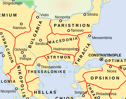
Català: Un mapa que mostra els temes bizantins (unitats administratives) de l'Imperi Bizantí l'any 1045 dC, centrat en els Balcans centrals al voltant de la regió de Macedònia. El tema macedoni es troba en el que avui forma part de l'actual Bulgària, mentre que el tema búlgar inclou el que avui és la República de Macedònia del Nord. Tingueu en compte que els límits temàtics d'aquest mapa, especialment els d'Estrímon i Macedònia, són molt inexactes. Macedònia es trobava realment més al sud, fins a la costa de l'Egeu de Tràcia occidental
English: A map showing the Byzantine themata (administrative units) of the Byzantine Empire in 1045 CE, focusing on central Balkans around the region of Macedonia. The Macedonian thema is in what today is part of present-day Bulgaria, while the Bulgarian thema includes what today is the Republic of North Macedonia. Note that the thematic boundaries in this map, especially those of Strymon and Macedonia, are very inaccurate. Macedonia was actually located further south, up to the Aegean coast of western Thrace |
| 날짜 | |
| 출처 | This is a derivative work of a more complete map created by ArdadN of the English Wikipedia. |
| 저자 | NerdyNSK |
| 저작권 (이 파일을 인용하기) |
GFDL-1.2+, CC-BY-SA-3.0/2.5/2.0/1.0 |
| 다른 버전 |
This is a derivative work of a more complete map created by ArdadN of the English Wikipedia. File:Byzantine Macedonia 1045CE.svg has 2 translations.
Other related versions: []
|


|
이 SVG 파일은 편집 가능한 문자를 사용하므로 Inkscape나 Adobe Illustrator를 사용하여 쉽게 다른 언어로 번역할 수 있습니다. 여기를 참고하세요. 또한 텍스트 편집기를 이용하여 수동으로 파일을 번역할 수도 있습니다. |
이 파일은 SVG <switch> 요소를 사용하여 번역되었습니다. 모든 번역들은 같은 파일에 저장됩니다! 여기를 참고하세요.
번역이 완료된 당신의 언어에서 이 파일을 이용할 때에는 언어 코드와 To translate the text into your language, you can use the SVG Translate tool. Alternatively, you can download the file to your computer, add your translations using whatever software you're familiar with, and re-upload it with the same name. You will find help in Graphics Lab if you're not sure how to do this. |
라이선스[편집]

|
GNU 자유 문서 사용 허가서 1.2판 또는 자유 소프트웨어 재단에서 발행한 이후 판의 규정에 따라 본 문서를 복제하거나 개작 및 배포할 수 있습니다. 본 문서에는 변경 불가 부분이 없으며, 앞 표지 구절과 뒷 표지 구절도 없습니다. 본 사용 허가서의 전체 내용은 GNU 자유 문서 사용 허가서 부분에 포함되어 있습니다. |
- 이용자는 다음의 권리를 갖습니다:
- 공유 및 이용 – 저작물의 복제, 배포, 전시, 공연 및 공중송신
- 재창작 – 저작물의 개작, 수정, 2차적저작물 창작
- 다음과 같은 조건을 따라야 합니다:
- 저작자표시 – 적절한 저작자 표시를 제공하고, 라이센스에 대한 링크를 제공하고, 변경사항이 있는지를 표시해야 합니다. 당신은 합리적인 방식으로 표시할 수 있지만, 어떤 방식으로든 사용권 허가자가 당신 또는 당신의 사용을 지지하는 방식으로 표시할 수 없습니다.
- 동일조건변경허락 – 만약 당신이 이 저작물을 리믹스 또는 변형하거나 이 저작물을 기반으로 제작하는 경우, 당신은 당신의 기여물을 원저작물과 동일하거나 호환 가능한 라이선스에 따라 배포하여야 합니다.
파일 역사
날짜/시간 링크를 클릭하면 해당 시간의 파일을 볼 수 있습니다.
| 날짜/시간 | 섬네일 | 크기 | 사용자 | 설명 | |
|---|---|---|---|---|---|
| 현재 | 2024년 2월 11일 (일) 16:05 | | 423 × 335 (457 KB) | Manlleus (토론 | 기여) | File uploaded using svgtranslate tool (https://svgtranslate.toolforge.org/). Added translation for ca. |
| 2024년 2월 10일 (토) 07:58 |  | 423 × 335 (457 KB) | Leptictidium (토론 | 기여) | File uploaded using svgtranslate tool (https://svgtranslate.toolforge.org/). Added translation for ca. | |
| 2024년 2월 10일 (토) 07:50 |  | 423 × 335 (457 KB) | Leptictidium (토론 | 기여) | File uploaded using svgtranslate tool (https://svgtranslate.toolforge.org/). Added translation for ca. | |
| 2024년 2월 9일 (금) 19:52 |  | 423 × 335 (447 KB) | Manlleus (토론 | 기여) | added catalan language | |
| 2017년 5월 4일 (목) 21:30 |  | 423 × 335 (407 KB) | Kandi (토론 | 기여) | Reverted to version as of 05:00, 4 April 2008 (UTC) | |
| 2017년 5월 4일 (목) 21:15 |  | 4,252 × 6,013 (317 KB) | Kandi (토론 | 기여) | new, more detailed version | |
| 2008년 4월 4일 (금) 05:00 |  | 423 × 335 (407 KB) | NerdyNSK (토론 | 기여) | {{Information |Description=A map showing the Byzantine themata (administrative units) of the Byzantine Empire in 1045 CE, focusing on central Balkans around the region of Macedonia. The Macedonian thema is in what today is part of present-day Bulgaria, w |
이 파일을 덮어쓸 수 없습니다.
이 파일을 사용하는 문서
다음 문서 6개가 이 파일을 사용하고 있습니다:
이 파일을 사용하고 있는 모든 위키의 문서 목록
다음 위키에서 이 파일을 사용하고 있습니다:
- af.wikipedia.org에서 이 파일을 사용하고 있는 문서 목록
- als.wikipedia.org에서 이 파일을 사용하고 있는 문서 목록
- ar.wikipedia.org에서 이 파일을 사용하고 있는 문서 목록
- azb.wikipedia.org에서 이 파일을 사용하고 있는 문서 목록
- ba.wikipedia.org에서 이 파일을 사용하고 있는 문서 목록
- be.wikipedia.org에서 이 파일을 사용하고 있는 문서 목록
- bg.wikipedia.org에서 이 파일을 사용하고 있는 문서 목록
- ca.wikipedia.org에서 이 파일을 사용하고 있는 문서 목록
- cs.wikipedia.org에서 이 파일을 사용하고 있는 문서 목록
- de.wikipedia.org에서 이 파일을 사용하고 있는 문서 목록
- el.wikipedia.org에서 이 파일을 사용하고 있는 문서 목록
- en.wikipedia.org에서 이 파일을 사용하고 있는 문서 목록
- fr.wikipedia.org에서 이 파일을 사용하고 있는 문서 목록
이 파일의 더 많은 사용 내역을 봅니다.