File:Caucasiamapussr.gif
Jump to navigation
Jump to search
കൂടുതൽ വ്യക്തതയുള്ള ചിത്രം ലഭ്യമല്ല.
Caucasiamapussr.gif (700 × 590 പിക്സൽ, പ്രമാണത്തിന്റെ വലിപ്പം: 81 കെ.ബി., മൈം തരം: image/gif)
തലവാചകം
തലവാചകങ്ങൾ
ഈ പ്രമാണം എന്തിനെ പ്രതിനിധീകരിക്കുന്നുവെന്ന ഒറ്റവരി വിശദീകരണം ചേർക്കുക

|
ഈ ചിത്രത്തിന്റെ ഒരു വെക്റ്റർ പതിപ്പ് (SVG) File:Soviet Caucasus map.svg ലഭ്യമാണ്.
ഈ ചിത്രത്തിനേക്കാൾ മികച്ച റസല്യൂഷൻ ആവശ്യമെങ്കിൽ ഈ റാസ്റ്റർ ചിത്രത്തിനു പകരം അതുപയോഗിക്കേണ്ടതാണ്. File:Caucasiamapussr.gif → File:Soviet Caucasus map.svg
വെക്റ്റർ ഗ്രാഫിക്സിനെക്കുറിച്ച് കൂടുതൽ അറിയണമെന്നുണ്ടെങ്കിൽ, എസ്.വി.ജി.യിലേയ്ക്കുള്ള മാറ്റം എന്ന താൾ കാണുക. മീഡിയവിക്കിയിൽ എസ്.വി.ജി.യ്ക്കുള്ള പിന്തുണ എന്നുമൊരു താൾ നിലവിലുണ്ട്. |
 |
ചുരുക്കം
[തിരുത്തുക]
| വിവരണം |
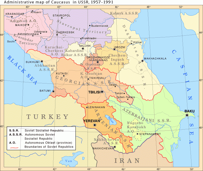
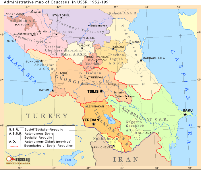
English: Administrative map of Caucasus in USSR, 1952-1991 |
| തീയതി |
Uploaded to Armenica.org before 7 ഡിസംബർ 2006 (archived version)
|
| സ്രോതസ്സ് | Originally uploded from en.wikipedia; description page is/was here. |
| സ്രഷ്ടാവ് | www.armenica.org |
| മറ്റു പതിപ്പുകൾ | العربيَّة |
അനുമതി
[തിരുത്തുക]

|
സ്വതന്ത്ര സോഫ്റ്റ്വേർ സമിതി പ്രസിദ്ധീകരിച്ചിട്ടുള്ള ഗ്നു സ്വതന്ത്ര പ്രമാണ അനുവാദപത്രം പതിപ്പ് 1.2 അല്ലെങ്കിൽ പുതിയ പതിപ്പുകൾ പ്രകാരം; മാറ്റമില്ലാത്ത ഭാഗങ്ങളില്ലാതെ, മുൻചട്ടയിലെ എഴുത്തുകൾ ഇല്ലാതെ, പിൻചട്ടയിലെ എഴുത്തുകൾ ഇല്ലാതെ പകർത്താനും, വിതരണം ചെയ്യാനും ഒപ്പം/അല്ലെങ്കിൽ ഈ പ്രമാണത്തിൽ മാറ്റം വരുത്തുവാനും ഉള്ള അവകാശങ്ങൾ നൽകുന്നു. ഗ്നു സ്വതന്ത്ര പ്രമാണ അനുവാദപത്രം എന്ന തലക്കെട്ടിൽ അനുവാദപത്രത്തിന്റെ ഒരു പകർപ്പ് ഉൾപ്പെടുത്തിയിട്ടുണ്ട്. |
This permission only applies to images existing on http://armenica.org/ as of 1 January 2007. Any later images do not fall under this permission!
യഥാർത്ഥ അപ്ലോഡ് രേഖ
[തിരുത്തുക]
(All user names refer to en.wikipedia)
- 2007-01-03 03:06 Artaxiad 700×590×6 (60613 bytes) Administrative map of [[Caucasus]] in USSR, 1952-1991 Source: Armenica.org [[Category:Armenica images]]
പ്രമാണ നാൾവഴി
ഏതെങ്കിലും തീയതി/സമയ കണ്ണിയിൽ ഞെക്കിയാൽ പ്രസ്തുതസമയത്ത് ഈ പ്രമാണം എങ്ങനെയായിരുന്നു എന്നു കാണാം.
| തീയതി/സമയം | ലഘുചിത്രം | അളവുകൾ | ഉപയോക്താവ് | അഭിപ്രായം | |
|---|---|---|---|---|---|
| നിലവിലുള്ളത് | 16:30, 10 മേയ് 2012 | | 700 × 590 (81 കെ.ബി.) | M0tty (സംവാദം | സംഭാവനകൾ) | Licence autorising modification → remove watermark |
| 20:03, 5 മേയ് 2012 |  | 700 × 591 (78 കെ.ബി.) | Geagea (സംവാദം | സംഭാവനകൾ) | Original map according to the OTRS permission. Not to be reverted. | |
| 04:49, 27 മാർച്ച് 2011 |  | 700 × 590 (81 കെ.ബി.) | Hellerick (സംവാദം | സംഭാവനകൾ) | The earlier changes were correct. | |
| 19:12, 16 ജനുവരി 2011 |  | 700 × 590 (59 കെ.ബി.) | Geagea (സംവാദം | സംഭാവനകൾ) | Reverted to version as of 10:16, 24 February 2007. To the uploader's last version | |
| 18:38, 16 ജനുവരി 2011 |  | 700 × 590 (81 കെ.ബി.) | Nicolay Sidorov (സംവാദം | സംഭാവനകൾ) | Adygea to Krasnodar, Karachay-Cherkess to Stavropol. | |
| 18:31, 16 ജനുവരി 2011 |  | 700 × 590 (80 കെ.ബി.) | Nicolay Sidorov (സംവാദം | സംഭാവനകൾ) | The Chechen-Ingush republic was restored on January 9, 1957 | |
| 10:16, 24 ഫെബ്രുവരി 2007 |  | 700 × 590 (59 കെ.ബി.) | Hardscarf (സംവാദം | സംഭാവനകൾ) | {{Information |Description=Administrative map of en:Caucasus in USSR, 1952-1991 |Source=Armenica.org {{ConfirmationImageOTRS|source=http://armenica.org/|otrs=2007010210006387}} Originally from [http://en.wikipedia.org en.wikipedia]; description page |
ഈ പ്രമാണത്തിനു മുകളിൽ മറ്റൊരു പ്രമാണം ചേർക്കാൻ താങ്കൾക്ക് കഴിയില്ല.
പ്രമാണത്തിന്റെ ഉപയോഗം
താഴെ കാണുന്ന 13 താളുകളിൽ ഈ ചിത്രം ഉപയോഗിക്കുന്നു:
പ്രമാണത്തിന്റെ ആഗോള ഉപയോഗം
താഴെ കൊടുത്തിരിക്കുന്ന മറ്റ് വിക്കികൾ ഈ പ്രമാണം ഉപയോഗിക്കുന്നു:
- ar.wikipedia.org സംരംഭത്തിലെ ഉപയോഗം
- azb.wikipedia.org സംരംഭത്തിലെ ഉപയോഗം
- az.wikipedia.org സംരംഭത്തിലെ ഉപയോഗം
- ca.wikipedia.org സംരംഭത്തിലെ ഉപയോഗം
- el.wikipedia.org സംരംഭത്തിലെ ഉപയോഗം
- en.wikipedia.org സംരംഭത്തിലെ ഉപയോഗം
- et.wikipedia.org സംരംഭത്തിലെ ഉപയോഗം
- fi.wikipedia.org സംരംഭത്തിലെ ഉപയോഗം
- fo.wikipedia.org സംരംഭത്തിലെ ഉപയോഗം
- he.wikipedia.org സംരംഭത്തിലെ ഉപയോഗം
- hi.wikipedia.org സംരംഭത്തിലെ ഉപയോഗം
- hr.wikipedia.org സംരംഭത്തിലെ ഉപയോഗം
- id.wikipedia.org സംരംഭത്തിലെ ഉപയോഗം
- is.wikipedia.org സംരംഭത്തിലെ ഉപയോഗം
- ja.wikipedia.org സംരംഭത്തിലെ ഉപയോഗം
- jv.wikipedia.org സംരംഭത്തിലെ ഉപയോഗം
- ko.wikipedia.org സംരംഭത്തിലെ ഉപയോഗം
- nn.wikipedia.org സംരംഭത്തിലെ ഉപയോഗം
- no.wikipedia.org സംരംഭത്തിലെ ഉപയോഗം
- pl.wiktionary.org സംരംഭത്തിലെ ഉപയോഗം
- ro.wikipedia.org സംരംഭത്തിലെ ഉപയോഗം
- ru.wikipedia.org സംരംഭത്തിലെ ഉപയോഗം
- simple.wikipedia.org സംരംഭത്തിലെ ഉപയോഗം
ഈ പ്രമാണത്തിന്റെ കൂടുതൽ ആഗോള ഉപയോഗം കാണുക.
വർഗ്ഗങ്ങൾ:
- Maps of the history of the Caucasus under Soviet rule
- 20th-century maps of the Caucasus
- Maps of the history of the south Caucasus region
- Maps of the history of Naxçıvan
- Maps of the history of Ajaria
- Maps of the history of Abkhazia
- Maps of the history of South Ossetia
- Maps of the history of Adygea
- Maps of the history of Karachay-Cherkessia
- Maps of the history of Kabardino-Balkaria
- Maps of the history of North Ossetia – Alania
- Maps of the history of Ingushetia
- Maps of the history of Chechnya
- Maps of the history of Dagestan
- Maps of the history of Kalmykia
- Maps of the Armenian Soviet Socialist Republic
- Maps of the Azerbaijan Soviet Socialist Republic
- Maps of the Georgian Soviet Socialist Republic
- Maps of the Russian Soviet Federative Socialist Republic
- Maps of the Transcaucasian Socialist Federative Soviet Republic
- English-language maps showing history