File:Cypress structure.jpeg
קפיצה לניווט
קפיצה לחיפוש
גודל התצוגה המקדימה הזאת: 800 × 521 פיקסלים. רזולוציות אחרות: 320 × 208 פיקסלים | 640 × 416 פיקסלים | 1,024 × 666 פיקסלים | 1,280 × 833 פיקסלים | 2,560 × 1,666 פיקסלים | 3,590 × 2,336 פיקסלים.
לקובץ המקורי (3,590 × 2,336 פיקסלים, גודל הקובץ: 9.9 מ"ב, סוג MIME: image/jpeg)
כיתובים
כיתובים
נא להוסיף משפט שמסביר מה הקובץ מייצג
תקציר
[עריכה]| תיאור |
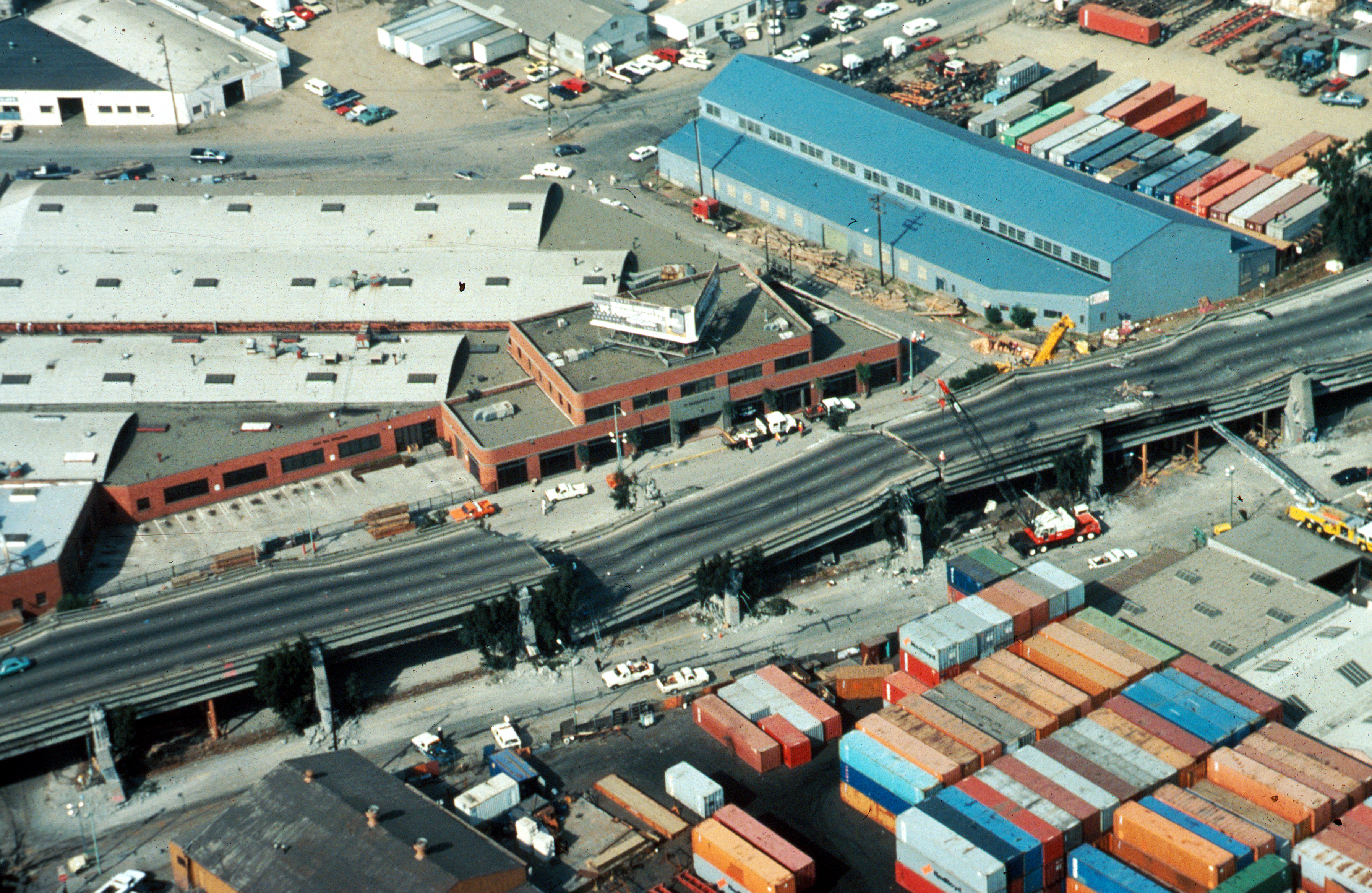
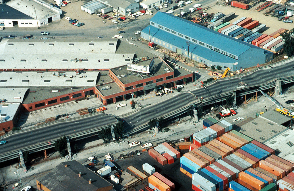
USGS photo from 1989 Loma Prieta earthquake. Caption: Aerial view of collapsed sections of the en:Cypress Viaduct of en:Interstate 880. [H.G. Wilshire, U.S. Geological Survey] |
| תאריך יצירה | |
| מקור |
Photo by H. G. Wilshire for U.S. Geological Survey. High res version on line at : [1] Lower resolution version: Original image here: http://pubs.usgs.gov/dds/dds-29/web_pages/oakland.html |
| יוצר | H.G. Wilshire, U.S. Geological Survey |
| אישורים והיתרים (שימוש חוזר בקובץ זה) |
PD-USGOV-INTERIOR-USGS. |
| גרסאות אחרות |
|

רישיון
[עריכה]
This image is in the public domain in the United States because it only contains materials that originally came from the United States Geological Survey, an agency of the United States Department of the Interior. For more information, see the official USGS copyright policy.
|
היסטוריית הקובץ
ניתן ללחוץ על תאריך/שעה כדי לראות את הקובץ כפי שנראה באותו זמן.
| תאריך/שעה | תמונה ממוזערת | ממדים | משתמש | הערה | |
|---|---|---|---|---|---|
| נוכחית | 17:57, 16 באוקטובר 2009 | | 2,336 × 3,590 (9.9 מ"ב) | Infrogmation (שיחה | תרומות) | High res version |
| 05:27, 30 בנובמבר 2006 |  | 512 × 763 (64 ק"ב) | Zzyzx11 (שיחה | תרומות) | {{Information |Description=[http://wrgis.wr.usgs.gov/dds/dds-29/ USGS photo] from 1989 en:Loma Prieta earthquake. '''Caption''': Aerial view of collapsed sections of the en:Cypress Viaduct of en:Interstate 880. [H.G. Wilshire, U.S. Geolo |
אין באפשרותך לדרוס את הקובץ הזה.
שימוש בקובץ
הדפים הבאים משתמשים בקובץ הזה:
שימוש גלובלי בקובץ
אתרי הוויקי השונים הבאים משתמשים בקובץ זה:
- שימוש באתר af.wikipedia.org
- שימוש באתר ar.wikipedia.org
- שימוש באתר azb.wikipedia.org
- שימוש באתר az.wikipedia.org
- שימוש באתר bg.wikipedia.org
- שימוש באתר da.wikipedia.org
- שימוש באתר de.wikipedia.org
- שימוש באתר de.wikivoyage.org
- שימוש באתר en.wikipedia.org
- Oakland, California
- 1989 Loma Prieta earthquake
- Interstate 880 (California)
- Wikipedia:Selected anniversaries/October 17
- MacArthur Maze
- Cypress Street Viaduct
- Portal:San Francisco Bay Area/Selected article/Archive
- Seismic microzonation
- User:Jer10 95/earthquakeprone
- User:DiRkdARyL
- Wikipedia talk:WikiProject Userboxes/New Userboxes/Archive 13
- 1989 in the United States
- Portal:San Francisco Bay Area/Selected article/18
- שימוש באתר es.wikipedia.org
- שימוש באתר fi.wikipedia.org
- שימוש באתר he.wikipedia.org
- שימוש באתר hi.wikipedia.org
- שימוש באתר id.wikipedia.org
- שימוש באתר it.wikipedia.org
- שימוש באתר ja.wikipedia.org
- שימוש באתר ko.wikipedia.org
- שימוש באתר ms.wikipedia.org
- שימוש באתר pam.wikipedia.org
- שימוש באתר pl.wikipedia.org
- שימוש באתר pt.wikipedia.org
- שימוש באתר ro.wikipedia.org
- שימוש באתר ru.wikipedia.org
- שימוש באתר simple.wikipedia.org
- שימוש באתר sr.wikipedia.org
- שימוש באתר sv.wikipedia.org
- שימוש באתר th.wikipedia.org
- שימוש באתר tr.wikipedia.org
צפייה בשימושים גלובליים נוספים של קובץ זה.