File:Cyprus-topographic map-en.svg
Jump to navigation
Jump to search

Size of this PNG preview of this SVG file: 741 × 600 pixels. Other resolutions: 297 × 240 pixels | 593 × 480 pixels | 949 × 768 pixels | 1,265 × 1,024 pixels | 2,530 × 2,048 pixels | 2,028 × 1,642 pixels.
Original file (SVG file, nominally 2,028 × 1,642 pixels, file size: 3.15 MB)
Captions
Captions
Add a one-line explanation of what this file represents
Summary[edit]
| Description |
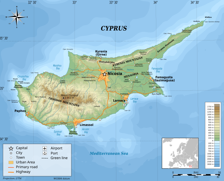
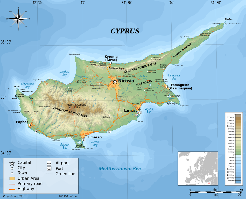
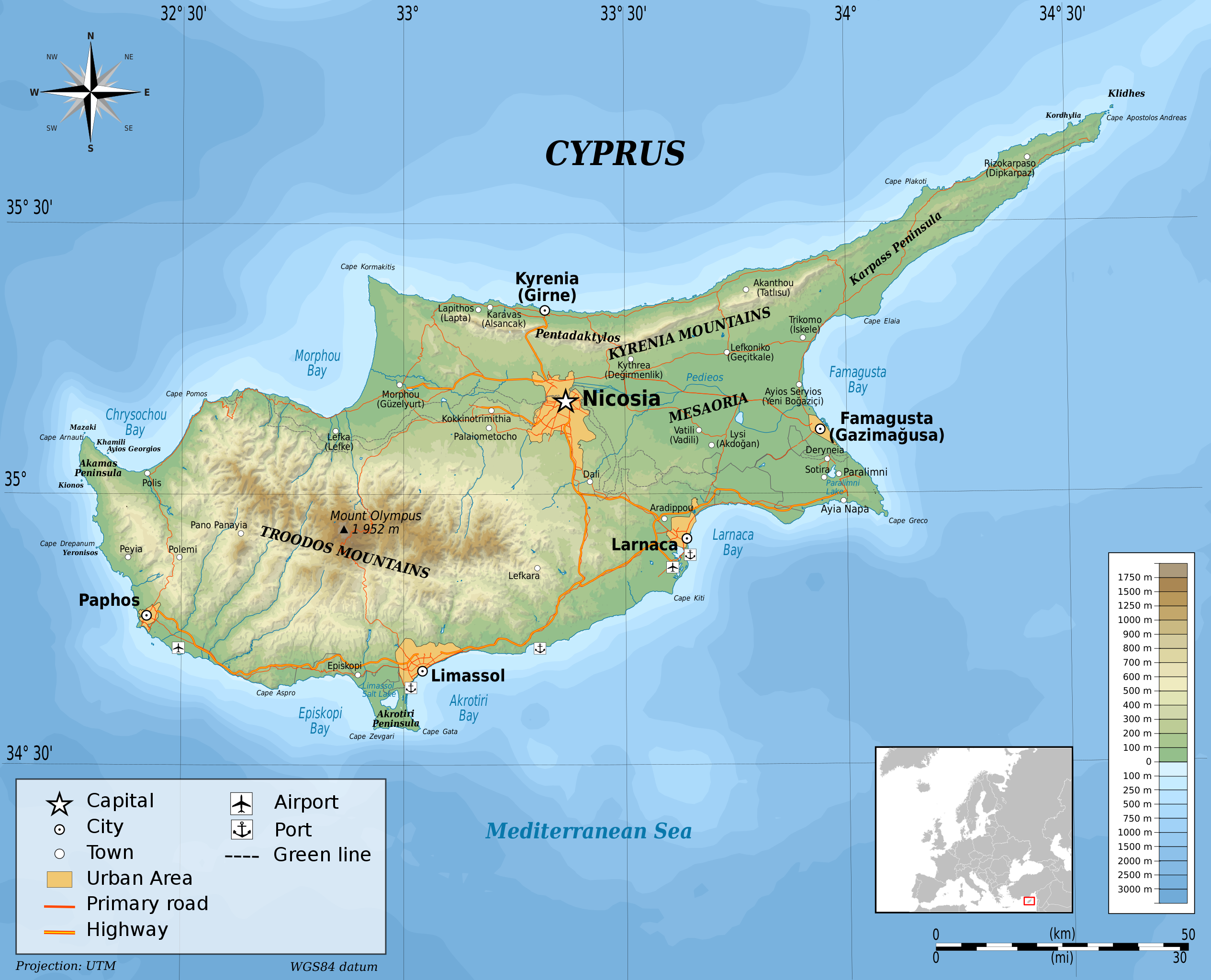
English: Topographic map of Cyprus Français : Carte topographique de Chypre
UTM projection, WGS84 datum Geographic limits of the map:
|
| Date | |
| Source |
Own work Sources of data:
|
| Author | Ikonact |

|
This SVG file contains embedded text that can be translated into your language, using any capable SVG editor, text editor or the SVG Translate tool. For more information see: About translating SVG files. |
W3C-validity not checked.
Licensing[edit]
I, the copyright holder of this work, hereby publish it under the following license:
This file is licensed under the Creative Commons Attribution-Share Alike 3.0 Unported license.
- You are free:
- to share – to copy, distribute and transmit the work
- to remix – to adapt the work
- Under the following conditions:
- attribution – You must give appropriate credit, provide a link to the license, and indicate if changes were made. You may do so in any reasonable manner, but not in any way that suggests the licensor endorses you or your use.
- share alike – If you remix, transform, or build upon the material, you must distribute your contributions under the same or compatible license as the original.
File history
Click on a date/time to view the file as it appeared at that time.
| Date/Time | Thumbnail | Dimensions | User | Comment | |
|---|---|---|---|---|---|
| current | 20:28, 4 September 2014 | | 2,028 × 1,642 (3.15 MB) | Ikonact (talk | contribs) | valid svg |
| 07:51, 1 September 2014 |  | 2,028 × 1,642 (2.94 MB) | Ikonact (talk | contribs) | bathymetry correction | |
| 22:23, 31 August 2014 |  | 2,028 × 1,642 (3.17 MB) | Ikonact (talk | contribs) | better quality, more geographic names | |
| 23:12, 29 August 2014 |  | 2,028 × 1,642 (3.07 MB) | Ikonact (talk | contribs) | more names added | |
| 20:09, 29 August 2014 |  | 2,028 × 1,642 (3.05 MB) | Ikonact (talk | contribs) | names of mountains | |
| 17:51, 29 August 2014 |  | 2,028 × 1,642 (3.05 MB) | Ikonact (talk | contribs) | names placed correctly | |
| 08:26, 4 May 2014 |  | 2,028 × 1,642 (3.05 MB) | Fern 24 (talk | contribs) | Uploaded wrong version. | |
| 08:16, 4 May 2014 |  | 2,028 × 1,642 (3.05 MB) | Fern 24 (talk | contribs) | Fixed typos, aligned and repositioned a few labels. | |
| 21:19, 5 November 2012 |  | 2,028 × 1,642 (3.05 MB) | Ikonact (talk | contribs) | User created page with UploadWizard |
You cannot overwrite this file.
File usage on Commons
The following 6 pages use this file:
File usage on other wikis
The following other wikis use this file:
- Usage on el.wikipedia.org
- Usage on en.wikipedia.org
- User:Dimadick
- User:Dan Koehl
- User:Harry Wood
- User:PaulinSaudi
- User:Radagast
- User:Sjc196
- User:Pepoluan
- Wikipedia:WikiProject Maps
- User:BrendanRyan
- User:Spicyjack
- User:Jusjih
- User:Acad Ronin
- User:Skal
- User:Steve Farrell
- User:Ranma9617
- User:Jaques O. Carvalho
- User:Ua747sp
- User:AlexTheMartian
- User:Rashed
- User:Professorbikeybike
- User:Saga City
- User:Mikeaitch
- User:Flyingcheese
- User:Parihav
- User:Tabletop
- User:Makaristos
- User:Njk
- User:Spellcheck
- User:Riadlem
- User:Mukkakukaku
- User:Mjvan12
- User:Jared Preston
- User:N8foo
- User:Epolk
- User:Gcapp1959
- User:Toucan6
- User:Kasper Holl
- User:Petros63
- User:Bradybd
- User:Schzmo
- User:Mysid
- User:Burwellian
- User:Tigershrike
- User:Le Anh-Huy
- User:Kmusser
- User:Chingwakabungya
- User:Scotthatton
- User:HoratioVitero
- User:Ottar~enwiki
View more global usage of this file.