File:DEMAlpesEW.png
Jump to navigation
Jump to search

Size of this preview: 800 × 477 pixels. Other resolutions: 320 × 191 pixels | 640 × 381 pixels | 1,024 × 610 pixels | 1,280 × 763 pixels | 2,089 × 1,245 pixels.
Original file (2,089 × 1,245 pixels, file size: 3.24 MB, MIME type: image/png)
Captions
Captions
Add a one-line explanation of what this file represents
Summary[edit]
| Description |
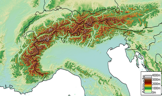
Español: Mapa digital de los Alpes, desde Niza hasta Viena
Digital Elevation Model of the Alps, from Nice (France) to Vienna (Austria) created by jide from the GTOPO30 dataset (pixel size ~1km). |
| Date | 2 December 2005 (original upload date) |
| Source | No machine-readable source provided. Own work assumed (based on copyright claims). |
| Author | No machine-readable author provided. Jide~commonswiki assumed (based on copyright claims). |
Licensing[edit]
I, the copyright holder of this work, hereby publish it under the following licenses:

|
Permission is granted to copy, distribute and/or modify this document under the terms of the GNU Free Documentation License, Version 1.2 or any later version published by the Free Software Foundation; with no Invariant Sections, no Front-Cover Texts, and no Back-Cover Texts. A copy of the license is included in the section entitled GNU Free Documentation License. |
| This file is licensed under the Creative Commons Attribution-Share Alike 3.0 Unported license. | ||
| ||
| This licensing tag was added to this file as part of the GFDL licensing update. |
This file is licensed under the Creative Commons Attribution-Share Alike 2.5 Generic, 2.0 Generic and 1.0 Generic license.
- You are free:
- to share – to copy, distribute and transmit the work
- to remix – to adapt the work
- Under the following conditions:
- attribution – You must give appropriate credit, provide a link to the license, and indicate if changes were made. You may do so in any reasonable manner, but not in any way that suggests the licensor endorses you or your use.
- share alike – If you remix, transform, or build upon the material, you must distribute your contributions under the same or compatible license as the original.
You may select the license of your choice.
| Annotations | This image is annotated: View the annotations at Commons |
File history
Click on a date/time to view the file as it appeared at that time.
| Date/Time | Thumbnail | Dimensions | User | Comment | |
|---|---|---|---|---|---|
| current | 12:04, 18 October 2023 | | 2,089 × 1,245 (3.24 MB) | Rémih (talk | contribs) | Cropped 9 % horizontally, 13 % vertically using CropTool with precise mode. |
| 21:02, 25 August 2015 |  | 2,285 × 1,427 (3.29 MB) | Vijfendertig (talk | contribs) | resized file | |
| 23:09, 2 December 2005 |  | 3,128 × 1,427 (3.5 MB) | Jide~commonswiki (talk | contribs) | DEM of the Alps created by jide from the (~1km pixel size) GTOPO30 dataset. | |
| 22:56, 2 December 2005 |  | 3,128 × 1,979 (4.14 MB) | Jide~commonswiki (talk | contribs) | Digital Elevation Model of the Alps, from Nice (France) to Vienna (Austria). |
You cannot overwrite this file.
File usage on Commons
There are no pages that use this file.
File usage on other wikis
The following other wikis use this file:
- Usage on ast.wikipedia.org
- Usage on bg.wikipedia.org
- Usage on cy.wikipedia.org
- Usage on de.wikipedia.org
- Usage on en.wikipedia.org
- Usage on fr.wikipedia.org
- Usage on id.wikipedia.org
- Usage on it.wikipedia.org
- Usage on nn.wikipedia.org
- Usage on pl.wikipedia.org