File:Day Pass down the Red Sea.ogv
Jump to navigation
Jump to search
Size of this JPG preview of this OGG file: 800 × 531 pixels. Other resolutions: 320 × 213 pixels | 640 × 425 pixels | 840 × 558 pixels.
Original file (Ogg Theora video file, length 16 s, 840 × 558 pixels, 2.04 Mbps, file size: 3.79 MB)
Captions
Captions
Add a one-line explanation of what this file represents
Summary[edit]
| Description |
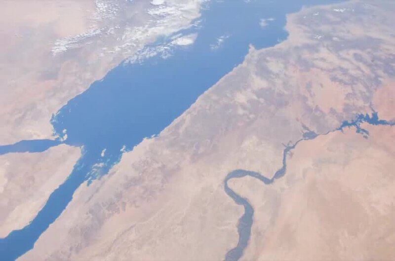
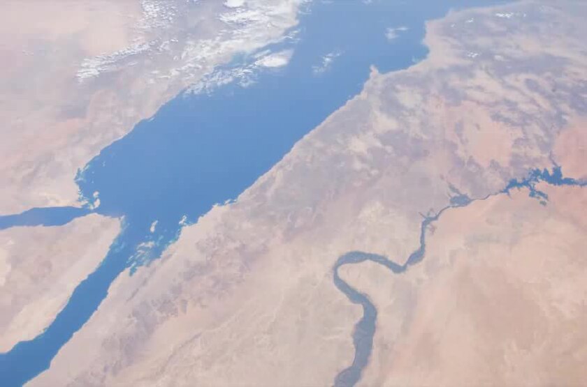
English: This video over the south-eastern Mediterranean Sea and down the coastline of the Red Sea was taken by the crew of Expedition 29 on board the International Space Station. This sequence of shots was taken September 17, 2011 from 12:14:25 to 12:24:55 GMT, on a descending pass from southern Greece to the Horn of Africa. The Nile River Delta that drains into the Mediterranean Sea can be seen well near the beginning of the video. As the ISS continues on its descending track south-east down the Red Sea, a thunderstorm can be seen just north of Djibouti. |
| Date | |
| Source | The Gateway to Astronaut Photography of Earth |
| Author | ISS Expedition 29 crew |
Licensing[edit]
| This file is in the public domain in the United States because it was solely created by NASA. NASA copyright policy states that "NASA material is not protected by copyright unless noted". (See Template:PD-USGov, NASA copyright policy page or JPL Image Use Policy.) | ||
 |
Warnings:
|
File history
Click on a date/time to view the file as it appeared at that time.
| Date/Time | Thumbnail | Dimensions | User | Comment | |
|---|---|---|---|---|---|
| current | 13:10, 24 October 2011 | 16 s, 840 × 558 (3.79 MB) | Originalwana (talk | contribs) | {{Information |Description ={{en|1=This video over the south-eastern Mediterranean Sea and down the coastline of the Red Sea was taken by the crew of Expedition 29 on board the International Space Station. This s |
You cannot overwrite this file.
File usage on Commons
There are no pages that use this file.
Transcode status
Update transcode statusFile usage on other wikis
The following other wikis use this file:
- Usage on ar.wikipedia.org
- Usage on ban.wikipedia.org
- Usage on bn.wikipedia.org
- Usage on ceb.wikipedia.org
- Usage on en.wikipedia.org
- Usage on hak.wikipedia.org
- Usage on hif.wikipedia.org
- Usage on id.wikipedia.org
- Usage on ig.wikipedia.org
- Usage on ilo.wikipedia.org
- Usage on mai.wikipedia.org
- Usage on ms.wikipedia.org
- Usage on ne.wikipedia.org
- Usage on pa.wikipedia.org
- Usage on ps.wikipedia.org
- Usage on sl.wikipedia.org
- Usage on su.wikipedia.org
- Usage on te.wikipedia.org
- Usage on zh-min-nan.wikipedia.org
- Usage on zh-yue.wikipedia.org