File:Dunottar School - geograph.org.uk - 726246.jpg
Pereiti į navigaciją
Jump to search
Geresnė raiška negalima.
Dunottar_School_-_geograph.org.uk_-_726246.jpg (640 × 480 taškų, rinkmenos dydis: 71 KiB, MIME tipas: image/jpeg)
Captions
Captions
Add a one-line explanation of what this file represents
Aprašymas
[keisti]
| Aprašymas |
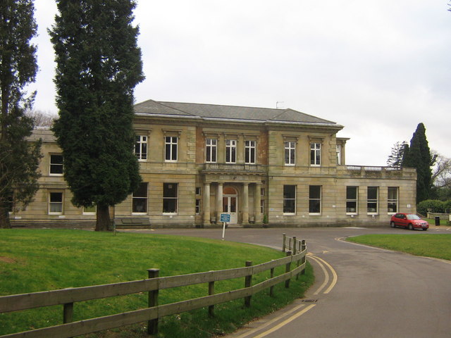
English: Dunottar School. Founded in 1926, this independent girls' school moved here in 1933, into "High Trees", built by Walter Blanford Waterlow in 1867 (see 645468 for more information on him). |
| Data | |
| Šaltinis | From geograph.org.uk |
| Autorius | Ian Capper |
| Autoriaus nurodymas (required by the license) | Ian Capper / Dunottar School / |
| Fotografijos koordinatės | | Šis ir kiti paveikslėliai: OpenStreetMap |
|---|
_heading:180.00&language=lt)
| Objekto koordinatės | | Šis ir kiti paveikslėliai: OpenStreetMap |
|---|
_heading:180.00&language=lt)
Licencija
[keisti]

|
This image was taken from the Geograph project collection. See this photograph's page on the Geograph website for the photographer's contact details. The copyright on this image is owned by Ian Capper and is licensed for reuse under the Creative Commons Attribution-ShareAlike 2.0 license.
|
Šiam failui taikoma Creative Commons Attribution-Share Alike 2.0 Generic licencija.
Autoriaus nurodymas: Ian Capper
- Jūs galite:
- dalintis – kopijuoti, platinti bei persiųsti šį darbą
- pri(si)taikyti – adaptuoti darbą
- Su šiomis sąlygomis:
- autoriaus nurodymas – Turite pateikti atitinkamą kreditą, pateikti nuorodą į licenciją ir nurodyti, ar buvo atlikti pakeitimai. Tai galite padaryti bet kokiu būdu, bet ne taip, kad licencijos išdavėjas patvirtintų jus ar jūsų naudojimą.
- dalinkis panašiai – Jei perdirbsite, redaguosite ar atkursite šį darbą, jį galėsite platinti tik su tokia pačia ar panašia į šią licencija.
- Remove redundant categories and try to put this image in the most specific category/categories
- Remove this template
- The location categories are based on information from this geonames tool and this OpenStreetMap tool combined with a database. You can also have a look at this tool from mysociety.
- The topic category from Geograph was School (find similar images at Geograph)
Rinkmenos istorija
Paspauskite ant datos/laiko, kad pamatytumėte rinkmeną tokią, kokia ji buvo tuo metu.
| Data/Laikas | Miniatiūra | Matmenys | Naudotojas | Paaiškinimas | |
|---|---|---|---|---|---|
| dabartinis | 04:30, 19 vasario 2011 | | 640 × 480 (71 KiB) | GeographBot (aptarimas | indėlis) | == {{int:filedesc}} == {{Information |description={{en|1=Dunottar School Founded in 1926, this independent girls' school moved here in 1933, into "High Trees", built by Walter Blanford Waterlow in 1867 (see 645468 for more information on him).}} |date |
Jūs negalite perrašyti šios rinkmenos.
Rinkmenos naudojimas
Rinkmena nėra naudojama jokiame puslapyje.
Visuotinis rinkmenos naudojimas
Ši rinkmena naudojama šiose viki svetainėse:
- Naudojama azb.wikipedia.org
- Naudojama en.wikipedia.org
- Naudojama lt.wikipedia.org