File:EAA2 Mississippi River Delta.pdf
Jump to navigation
Jump to search

Size of this JPG preview of this PDF file: 557 × 600 pixels. Other resolutions: 223 × 240 pixels | 446 × 480 pixels | 713 × 768 pixels | 951 × 1,024 pixels | 1,902 × 2,048 pixels | 3,900 × 4,200 pixels.
Original file (3,900 × 4,200 pixels, file size: 14.96 MB, MIME type: application/pdf)
Captions
Captions
Add a one-line explanation of what this file represents
| Description |
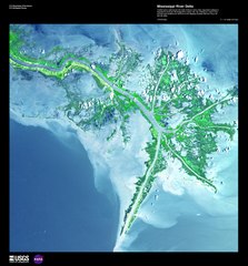
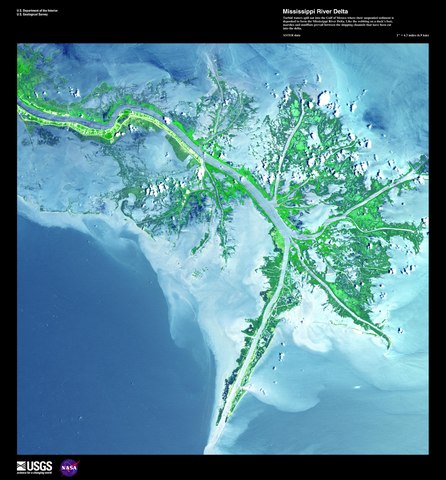
Earth-As-Art (EAA) satellite scenes Mississippi River Delta "Satellite scene chosen for aesthetic interest rather than for scientific interpretation" Mississipi River Delta, before the oil spill. These maps are satellite images chosen for their artistic quality. Locations from around the world as seen from 430 miles up. |
|||
| Date | ||||
| Source | direct | |||
| Author | ASTER data | |||
| Permission (Reusing this file) |
|
File history
Click on a date/time to view the file as it appeared at that time.
| Date/Time | Thumbnail | Dimensions | User | Comment | |
|---|---|---|---|---|---|
| current | 16:23, 25 December 2010 |  | 3,900 × 4,200 (14.96 MB) | Smallman12q (talk | contribs) | {{Information |Description= Earth-As-Art (EAA) satellite scenes Mississippi River Delta "Satellite scene chosen for aesthetic interest rather than for scientific interpretation" Mississipi River Delta, before the oil spill. These maps are satellite image |
You cannot overwrite this file.
File usage on Commons
There are no pages that use this file.
File usage on other wikis
The following other wikis use this file:
- Usage on hy.wikipedia.org
- Usage on uk.wikipedia.org