File:Elbe tributaries discharge diagram.svg
Vai alla navigazione
Vai alla ricerca

Dimensioni di questa anteprima PNG per questo file SVG: 800 × 600 pixel. Altre risoluzioni: 320 × 240 pixel | 640 × 480 pixel | 1 024 × 768 pixel | 1 280 × 960 pixel | 2 560 × 1 920 pixel | 1 600 × 1 200 pixel.
File originale (file in formato SVG, dimensioni nominali 1 600 × 1 200 pixel, dimensione del file: 23 KB)
Didascalie
Didascalie
Aggiungi una brevissima spiegazione di ciò che questo file rappresenta
| Descrizione |
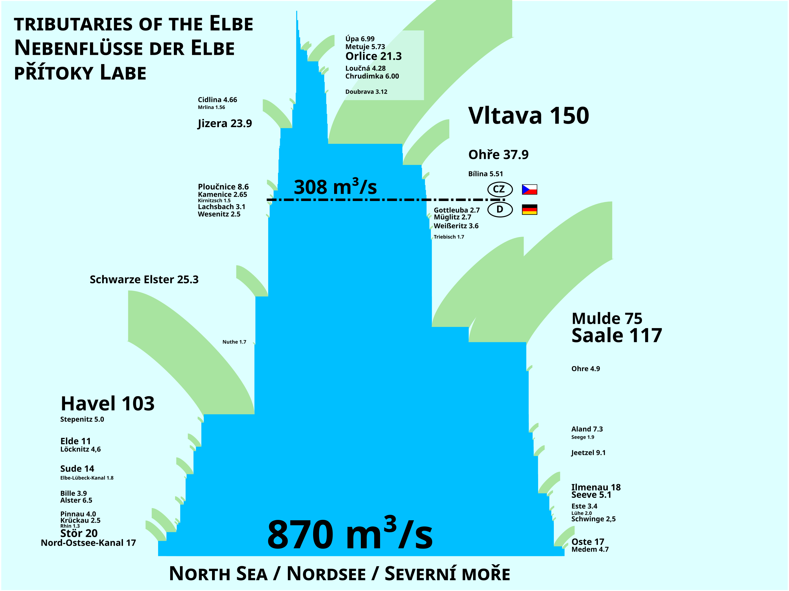
Čeština: Schéma řeky Labe a jejích přítoků z hlediska průměrného průtoku (MQ) v m³/s.
English: Scheme of the Elbe River and its tributaries showing average discharge (MQ) in m³/s.
Deutsch: Schema der Elbe und ihrer Zuflüsse. Gezeigt wird der durchschnittliche Zufluss in m³/s. |
| Data | |
| Fonte | Opera propria |
| Autore | Miaow |
| Altre versioni |
|
| SVG sviluppo | Questa mappa in grafica vettoriale è stata creata con un programma SVG ignoto. |

| Io, detentore del copyright su quest'opera, la rilascio nel pubblico dominio. Questa norma si applica in tutto il mondo. In alcuni paesi questo potrebbe non essere legalmente possibile. In tal caso: Garantisco a chiunque il diritto di utilizzare quest'opera per qualsiasi scopo, senza alcuna condizione, a meno che tali condizioni siano richieste dalla legge. |
Cronologia del file
Fare clic su un gruppo data/ora per vedere il file come si presentava nel momento indicato.
| Data/Ora | Miniatura | Dimensioni | Utente | Commento | |
|---|---|---|---|---|---|
| attuale | 11:59, 24 nov 2011 | | 1 600 × 1 200 (23 KB) | Miaow Miaow (discussione | contributi) | fmt (text position) |
| 21:47, 23 nov 2011 |  | 1 600 × 1 200 (23 KB) | Miaow Miaow (discussione | contributi) | typo (caps.) | |
| 21:43, 23 nov 2011 |  | 1 600 × 1 200 (23 KB) | Miaow Miaow (discussione | contributi) | {{Information |Description={{cs|Schéma řeky Labe a jejích přítoků z hlediska průměrného průtoku (MQ) v m³/s.}} {{en|Scheme of the Elbe River and its tributaries showing average discharge (MQ) in m³/s.}} |Source= { |
Impossibile sovrascrivere questo file.
Utilizzo del file
La seguente pagina usa questo file:
Utilizzo globale del file
Anche i seguenti wiki usano questo file:
- Usato nelle seguenti pagine di ar.wikipedia.org:
- Usato nelle seguenti pagine di bh.wikipedia.org:
- Usato nelle seguenti pagine di ca.wikipedia.org:
- Usato nelle seguenti pagine di cs.wikipedia.org:
- Usato nelle seguenti pagine di de.wikipedia.org:
- Usato nelle seguenti pagine di en.wikipedia.org:
- Usato nelle seguenti pagine di es.wikipedia.org:
- Usato nelle seguenti pagine di fa.wikipedia.org:
- Usato nelle seguenti pagine di fi.wikipedia.org:
- Usato nelle seguenti pagine di frr.wikipedia.org:
- Usato nelle seguenti pagine di fr.wikipedia.org:
- Usato nelle seguenti pagine di fy.wikipedia.org:
- Usato nelle seguenti pagine di it.wikipedia.org:
- Usato nelle seguenti pagine di lv.wikipedia.org:
- Usato nelle seguenti pagine di ml.wikipedia.org:
- Usato nelle seguenti pagine di mr.wikipedia.org:
- Usato nelle seguenti pagine di nl.wikipedia.org:
- Usato nelle seguenti pagine di no.wikipedia.org:
- Usato nelle seguenti pagine di pl.wikipedia.org:
- Usato nelle seguenti pagine di ru.wikipedia.org:
- Usato nelle seguenti pagine di sk.wikipedia.org:
- Usato nelle seguenti pagine di zh.wikipedia.org:
Metadati
Categorie:
- Diagrams of the Elbe
- Maps of the Elbe in Czechia
- Bílina (river)
- Diagrams about the Cidlina
- Diagrams about the Chrudimka
- Diagrams about the Doubrava River
- Jizera (river)
- Kamenice (Elbe tributary)
- Diagrams about the Loučná
- Metuje
- Mrlina
- Maps of the Ohře
- Orlice
- Ploučnice
- Diagrams about the Úpa
- Vltava
- Alster (River)
- Bille
- Elbe-Lübeck Canal
- Elde
- Este (Elbe)
- Gottleuba
- Maps of the Havel
- Ilmenau (Elbe)
- Jeetze
- Kiel Canal
- Kirnitzsch
- Löcknitz (river)
- Lühe (river)
- Maps of the Elbe in Germany
- Medem
- Mulde
- Ohre
- Oste
- Pinnau
- River discharge statistics
- Saale
- Schwarze Elster
- Seeve
- Stepenitz (Brandenburg)
- Stör
- Sude
- Tributaries of the Elbe
- Triebisch
- Weißeritz
- Wesenitz
- 2010s maps of Germany
- Rivers in 2011
- Trilingual Czech-English-German signs
- Czech-language diagrams
- English-language diagrams
- German-language diagrams