File:Etosha ESA357730.jpg
Original file (1,920 × 1,524 pixels, file size: 2.57 MB, MIME type: image/jpeg)
Captions
Captions
Summary
[edit]| Description |
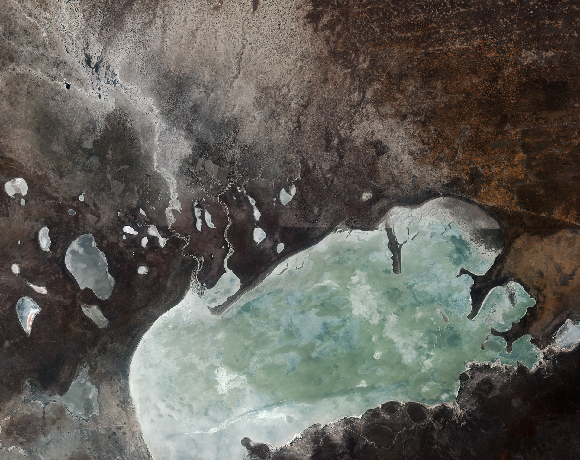
English: The Sentinel-2A satellite takes us over northern Namibia in this image from 18 September 2015.
The most prominent feature is the Etosha salt pan. It is believed that a lake was first formed tens of millions of years ago. More recently – mere thousands of years ago – the Kunene River would have flowed through this area, filling the large lake before tectonic movement changed the river course. The lake then dried up, leaving behind some 4800 sq km of exposed minerals. Today only the Ekuma River, seen flowing down from the upper left, feeds water into the pan – but very little water actually flows in as it seeps into the riverbed. Part of the wider Etosha National Park, the pan is a designated Ramsar wetland of international importance. It is the only known mass breeding ground for flamingos in Namibia, seeing as many as one million flamingos at a time during the wet season when rain water forms pools in parts of the pan. Built-up mounds of clay and salt throughout the pan also draw animals who use them as salt licks. Animals including lions, elephants, leopards and even black rhinoceroses can be seen in the park. The name ‘Etosha’ means ‘great white place’ in the language of the local Ovambo tribe – and looking at the image we understand why. The straight lines cutting across the image are roads, and the one on the right side clearly delineates the border of the protected park to the south. On the northern side of the road, we can see agricultural structures. This image is also featured on theEarth from Space video programme. |
| Date | |
| Source | http://www.esa.int/spaceinimages/Images/2016/03/Etosha |
| Author | European Space Agency |
| Permission (Reusing this file) |
Contains modified Copernicus Sentinel data [2015], processed by ESA,CC BY-SA 3.0 IGO |
| Other versions |
|
| Title | Etosha |
| Set | Earth observation image of the week |
| System | Copernicus |
| Mission | Sentinel-2 |
| Location | Namibia |
| Activity | Observing the Earth |
| Keywords | Satellite image; Wetlands; River; Salinity |
Licensing
[edit]
- You are free:
- to share – to copy, distribute and transmit the work
- to remix – to adapt the work
- Under the following conditions:
- attribution – You must give appropriate credit, provide a link to the license, and indicate if changes were made. You may do so in any reasonable manner, but not in any way that suggests the licensor endorses you or your use.
- share alike – If you remix, transform, or build upon the material, you must distribute your contributions under the same or compatible license as the original.

|
This image contains data from a satellite in the Copernicus Programme, such as Sentinel-1, Sentinel-2 or Sentinel-3. Attribution is required when using this image.
Attribution: Contains modified Copernicus Sentinel data {{{year}}}
The use of Copernicus Sentinel Data is regulated under EU law (Commission Delegated Regulation (EU) No 1159/2013 and Regulation (EU) No 377/2014). Relevant excerpts:
Free access shall be given to GMES dedicated data [...] made available through GMES dissemination platforms [...].
Access to GMES dedicated data [...] shall be given for the purpose of the following use in so far as it is lawful:
GMES dedicated data [...] may be used worldwide without limitations in time.
GMES dedicated data and GMES service information are provided to users without any express or implied warranty, including as regards quality and suitability for any purpose. |
File history
Click on a date/time to view the file as it appeared at that time.
| Date/Time | Thumbnail | Dimensions | User | Comment | |
|---|---|---|---|---|---|
| current | 16:24, 7 May 2017 | | 1,920 × 1,524 (2.57 MB) | Fæ (talk | contribs) | European Space Agency, Id 357730, http://www.esa.int/spaceinimages/Images/2016/03/Etosha, User:Fæ/Project_list/ESA |
You cannot overwrite this file.
File usage on Commons
The following page uses this file:
File usage on other wikis
The following other wikis use this file:
- Usage on pl.wikipedia.org
- Usage on pt.wikipedia.org
- Usage on uk.wikipedia.org