File:Europe map Napoleon 1811.png
둘러보기로 이동
검색으로 이동
최대 해상도입니다.
Europe_map_Napoleon_1811.png (415 × 397 픽셀, 파일 크기: 62 KB, MIME 종류: image/png)
캡션
설명
이 파일이 나타내는 바에 대한 한 줄 설명을 추가합니다


|
이 그림은 벡터 그래픽 버전(SVG)이 있습니다. 래스터(비트맵) 그림 대신 벡터 그래픽 그림을 사용하는 것이 좋습니다.
File:Europe map Napoleon 1811.png → File:Europe map Napoleon 1811.svg
|
 |
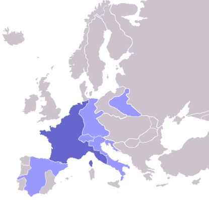
Map of the w:First French Empire and satellite states, with w:1811 borders. Created by User:OwenBlacker from Image:Europe blank map.png, therefore they are the source.
| 나는 이 작품의 저작권자로서, 이 작품을 퍼블릭 도메인으로 모두에게 공개합니다. 이 공개 선언은 전 세계적으로 유효합니다. 만약 저작권의 포기가 법률적으로 가능하지 않은 경우, 나는 이 작품을 법적으로 허용되는 한도 내에서 누구나 자유롭게 어떤 목적으로도 제한없이 사용할 수 있도록 허용합니다. |
derivative works
[편집]
이 파일은 다음으로 파생됨: Europe map Napoleon 1811.svg
파일 역사
날짜/시간 링크를 클릭하면 해당 시간의 파일을 볼 수 있습니다.
| 날짜/시간 | 섬네일 | 크기 | 사용자 | 설명 | |
|---|---|---|---|---|---|
| 현재 | 2022년 10월 11일 (화) 08:06 | | 415 × 397 (62 KB) | Рагин1987 (토론 | 기여) | Extended map |
| 2020년 7월 23일 (목) 13:01 |  | 415 × 422 (13 KB) | Leonel Sohns (토론 | 기여) | Reverted to version as of 00:53, 16 October 2006 (UTC) | |
| 2020년 7월 23일 (목) 13:01 |  | 415 × 422 (11 KB) | Leonel Sohns (토론 | 기여) | Recovered old version from archive.org | |
| 2006년 10월 16일 (월) 00:53 |  | 415 × 422 (13 KB) | Deltabeignet (토론 | 기여) | Corrected status of Illyrian provinces. | |
| 2005년 8월 21일 (일) 00:51 |  | 415 × 422 (11 KB) | OwenBlacker (토론 | 기여) | Map of the w:First French Empire and satellite states, with w:1811 borders. Created by User:OwenBlacker from Image:Europe blank map.png {{GFDL}} {{cc-by-sa-2.0-uk}} |
이 파일을 덮어쓸 수 없습니다.
이 파일을 사용하는 문서
다음 문서 14개가 이 파일을 사용하고 있습니다:
- Atlas of Belgium
- Atlas of European history
- Atlas of France
- Atlas of Galicia
- Atlas of Italy
- Atlas of Luxembourg
- Atlas of Spain
- Atlas of the early modern age
- Napoléon Bonaparte
- User:Magog the Ogre/Maps of conflicts/2020 July
- User:Magog the Ogre/Maps of conflicts/2022 October
- User:Minorax/SVG available/2022 October 7-12
- User:Thegranddesign31415
- File:Apogée Empire Napoleon 1811.jpg
이 파일을 사용하고 있는 모든 위키의 문서 목록
다음 위키에서 이 파일을 사용하고 있습니다:
- arz.wikipedia.org에서 이 파일을 사용하고 있는 문서 목록
- ast.wikipedia.org에서 이 파일을 사용하고 있는 문서 목록
- ba.wikipedia.org에서 이 파일을 사용하고 있는 문서 목록
- be.wikipedia.org에서 이 파일을 사용하고 있는 문서 목록
- bg.wikipedia.org에서 이 파일을 사용하고 있는 문서 목록
- bn.wikibooks.org에서 이 파일을 사용하고 있는 문서 목록
- bs.wikipedia.org에서 이 파일을 사용하고 있는 문서 목록
- ca.wikipedia.org에서 이 파일을 사용하고 있는 문서 목록
- cs.wikipedia.org에서 이 파일을 사용하고 있는 문서 목록
- cv.wikipedia.org에서 이 파일을 사용하고 있는 문서 목록
- de.wikibooks.org에서 이 파일을 사용하고 있는 문서 목록
- en.wikipedia.org에서 이 파일을 사용하고 있는 문서 목록
- en.wikibooks.org에서 이 파일을 사용하고 있는 문서 목록
- eo.wikipedia.org에서 이 파일을 사용하고 있는 문서 목록
- fi.wikipedia.org에서 이 파일을 사용하고 있는 문서 목록
- Cisalppinen tasavalta
- Batavian tasavalta
- Hollannin kuningaskunta
- Napolin kuningaskunta
- Helvetian tasavalta
- Ligurian tasavalta
- Varsovan herttuakunta
- Malline:Napoleonin vasallit
- Etrurian kuningaskunta
- Alban tasavalta
- Reinin liitto (1806)
- Italian tasavalta (vasalli)
- Mainzin tasavalta
- Italian kuningaskunta (Napoleon)
- Cispadaaninen tasavalta
- Westfalenin kuningaskunta
- Illyrian provinssit
- Transpadaaninen tasavalta
- fr.wikipedia.org에서 이 파일을 사용하고 있는 문서 목록
- fy.wikipedia.org에서 이 파일을 사용하고 있는 문서 목록
- gl.wikipedia.org에서 이 파일을 사용하고 있는 문서 목록
- he.wikipedia.org에서 이 파일을 사용하고 있는 문서 목록
- hr.wikipedia.org에서 이 파일을 사용하고 있는 문서 목록
- hu.wikipedia.org에서 이 파일을 사용하고 있는 문서 목록
이 파일의 더 많은 사용 내역을 봅니다.