File:Fedor chertezh.jpeg
Jump to navigation
Jump to search

Size of this preview: 764 × 600 pixels. Other resolutions: 306 × 240 pixels | 611 × 480 pixels | 978 × 768 pixels | 1,280 × 1,005 pixels | 2,560 × 2,010 pixels | 5,500 × 4,319 pixels.
Original file (5,500 × 4,319 pixels, file size: 4.68 MB, MIME type: image/jpeg)
Captions
Captions
Add a one-line explanation of what this file represents
Summary[edit]
| Description |
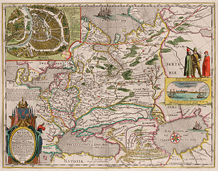
English: Map of Muscovy (the so-called Fedor Godunov map)
Русский: Карта России Гесселя Герритса (основанная на чертёже Фёдора Годунова) |
| Date | |
| Source | http://historydoc.edu.ru/catalog.asp?cat_ob_no=15906 |
| Author | Fedori Borisowitsi. Борисовича Годунова |
| Other versions | Derivative works of this file: Fedor chertezh cropped.jpg |
Licensing[edit]
|
This work is in the public domain in its country of origin and other countries and areas where the copyright term is the author's life plus 100 years or fewer. | |
| This file has been identified as being free of known restrictions under copyright law, including all related and neighboring rights. | |
File history
Click on a date/time to view the file as it appeared at that time.
| Date/Time | Thumbnail | Dimensions | User | Comment | |
|---|---|---|---|---|---|
| current | 18:11, 14 October 2015 | | 5,500 × 4,319 (4.68 MB) | Tso tso (talk | contribs) | Увеличено разрешение, лучшее качество цветопередачи |
| 10:52, 22 April 2015 |  | 1,918 × 1,500 (3.94 MB) | Ulti.paladin (talk | contribs) | 1614 - Hessel Gerritsz - Tabula Russiae ex autographo, quod delineandum curavit Foedor filius Tzaris Borois desumta . . . MDCXIIII | |
| 11:58, 29 August 2008 |  | 1,479 × 1,161 (375 KB) | Mitrius (talk | contribs) | {{Information |Description={{en|1=Map of Muscovy (the so-called Fedor Godunov map)}} {{ru|1=Карта России Гесселя Герритса (основанная на чертёже Фёдора Годунова)}} |Source=http://historydoc.edu.ru |
You cannot overwrite this file.
File usage on Commons
The following 4 pages use this file:
File usage on other wikis
The following other wikis use this file:
- Usage on ar.wikipedia.org
- Usage on azb.wikipedia.org
- Usage on az.wikipedia.org
- Usage on ca.wikipedia.org
- Usage on cs.wikipedia.org
- Usage on en.wikipedia.org
- Usage on eo.wikipedia.org
- Usage on es.wikipedia.org
- Usage on et.wikipedia.org
- Usage on eu.wikipedia.org
- Usage on fa.wikipedia.org
- Usage on gl.wikipedia.org
- Usage on he.wikipedia.org
- Usage on hy.wikipedia.org
- Usage on ja.wikipedia.org
- Usage on ko.wikipedia.org
- Usage on la.wikipedia.org
- Usage on lv.wikipedia.org
- Usage on pl.wikipedia.org
- Usage on ru.wikipedia.org
- Usage on sl.wikipedia.org
- Usage on tr.wikipedia.org
- Usage on tt.wikipedia.org
- Usage on uk.wikipedia.org