File:First ETR in China.svg
Jump to navigation
Jump to search

Size of this PNG preview of this SVG file: 705 × 599 pixels. Other resolutions: 282 × 240 pixels | 565 × 480 pixels | 904 × 768 pixels | 1,205 × 1,024 pixels | 2,409 × 2,048 pixels | 1,000 × 850 pixels.
Original file (SVG file, nominally 1,000 × 850 pixels, file size: 232 KB)
Captions
Captions
Add a one-line explanation of what this file represents
Summary[edit]
| Description |
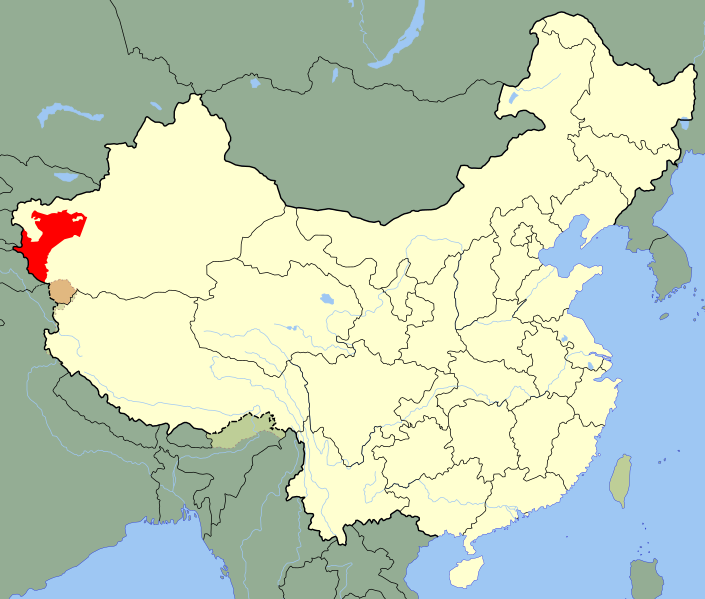
A SVG map of China with Xinjiang's Kashgar Prefecture highlighted in red; the modern-day district in which the w:en:First East Turkestan Republic was located. Legend: |
||
| Date | (UTC) | ||
| Source | |||
| Author |
|
||
| SVG development |
|
.svg)
| This is a retouched picture, which means that it has been digitally altered from its original version. Modifications: Unhighlighted Xinjiang as a whole, removed sub-provincial markers. The original can be viewed here: China Xinjiang Kashgar.svg:
|
Licensing[edit]
I, the copyright holder of this work, hereby publish it under the following license:
| I, the copyright holder of this work, release this work into the public domain. This applies worldwide. In some countries this may not be legally possible; if so: I grant anyone the right to use this work for any purpose, without any conditions, unless such conditions are required by law. |
Original upload log[edit]
This image is a derivative work of the following images:
- File:China_Xinjiang_Kashgar.svg licensed with PD-self
- 2010-02-12T14:52:39Z Joowwww 1000x850 (237684 Bytes) {{Information |Description=An SVG map of China with Xinjiang highlighted in orange and Kashgar Prefecture highlighted in red Legend:[[:File:China map legend.png]] |Source=self-made; based on CIA public domain maps: *http://w
Uploaded with derivativeFX
File history
Click on a date/time to view the file as it appeared at that time.
| Date/Time | Thumbnail | Dimensions | User | Comment | |
|---|---|---|---|---|---|
| current | 21:10, 24 May 2020 | | 1,000 × 850 (232 KB) | Roy17 (talk | contribs) | Reverted to version as of 23:09, 18 August 2010 (UTC) |
| 02:39, 24 May 2020 |  | 1,000 × 810 (249 KB) | Anchuhu (talk | contribs) | Reverted to version as of 12:39, 19 January 2019 (UTC) roc borders isn’t like China now | |
| 01:43, 12 March 2020 |  | 1,000 × 850 (232 KB) | Jonteemil (talk | contribs) | Reverted to version as of 23:09, 18 August 2010 (UTC) | |
| 12:39, 19 January 2019 |  | 1,000 × 810 (249 KB) | 复旦大学张超 (talk | contribs) | edit | |
| 23:09, 18 August 2010 |  | 1,000 × 850 (232 KB) | Splittist (talk | contribs) | {{Information |Description=A SVG map of China with Xinjiang's Kashgar Prefecture highlighted in red; the modern-day district in which the w:en:First East Turkestan Republic was located. Legend:<br />File:China map legend.png |Source=*[[:File:China |
You cannot overwrite this file.
File usage on Commons
The following page uses this file:
File usage on other wikis
The following other wikis use this file:
- Usage on ar.wikipedia.org
- Usage on azb.wikipedia.org
- Usage on az.wikipedia.org
- Usage on bn.wikipedia.org
- Usage on de.wikipedia.org
- Usage on en.wikipedia.org
- Usage on es.wikipedia.org
- Usage on eu.wikipedia.org
- Usage on fa.wikipedia.org
- Usage on fr.wikipedia.org
- Usage on id.wikipedia.org
- Usage on incubator.wikimedia.org
- Usage on it.wikipedia.org
- Usage on ja.wikipedia.org
- Usage on ko.wikipedia.org
- Usage on lv.wikipedia.org
- Usage on nl.wikipedia.org
- Usage on nn.wikipedia.org
- Usage on pl.wikipedia.org
- Usage on pnb.wikipedia.org
- Usage on pt.wikipedia.org
- Usage on ru.wikipedia.org
View more global usage of this file.