File:French Indochina locator.svg
Jump to navigation
Jump to search

Size of this PNG preview of this SVG file: 250 × 120 pixels. Other resolutions: 320 × 154 pixels | 640 × 307 pixels | 1,024 × 492 pixels | 1,280 × 614 pixels | 2,560 × 1,229 pixels.
Original file (SVG file, nominally 250 × 120 pixels, file size: 166 KB)
Captions
Captions
Add a one-line explanation of what this file represents
Summary[edit]
| Description |
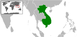
English: Location map of French Indochina
Deutsch: Lage von Französisch-Indochina |
|||
| Date | ||||
| Source | Own work, based on BlankMap-World7.svg and BlankMap World simple.svg | |||
| Author |
|
|||
| Permission (Reusing this file) |
|
|||
| Other versions |
|

File history
Click on a date/time to view the file as it appeared at that time.
| Date/Time | Thumbnail | Dimensions | User | Comment | |
|---|---|---|---|---|---|
| current | 13:23, 5 March 2015 | | 250 × 120 (166 KB) | Master Uegly (talk | contribs) | {{Information |Description ={{en|1=Location map of French Indochina}} {{de|1=Lage von Französisch-Indochina}} |Source ={{own}}, based on BlankMap-World7.svg and [[:File:BlankMap World simple.svg|BlankMap World... |
You cannot overwrite this file.
File usage on Commons
The following 3 pages use this file:
File usage on other wikis
The following other wikis use this file:
- Usage on ast.wiktionary.org
- Usage on azb.wikipedia.org
- Usage on br.wikipedia.org
- Usage on de.wikipedia.org
- Usage on eo.wikipedia.org
- Usage on eu.wikipedia.org
- Usage on he.wikipedia.org
- Usage on hr.wikipedia.org
- Usage on jv.wikipedia.org
- Usage on lt.wikipedia.org
- Usage on nl.wikipedia.org
- Usage on pl.wikipedia.org
- Usage on pl.wiktionary.org
- Usage on pt.wikipedia.org
- Usage on ro.wikipedia.org
- Usage on simple.wikipedia.org
- Usage on sk.wikipedia.org
- Usage on tl.wikipedia.org
- Usage on zh.wikipedia.org